NASA Landsat @NASA_Landsat
The NASA/USGS Landsat series of Earth-observing satellites has monitored our planet for 50 years. Verification: https://t.co/4p9BhINXeQ landsat.gsfc.nasa.gov Greenbelt, MD Joined November 2010-
Tweets18K
-
Followers80K
-
Following470
-
Likes12K
For more than a decade, Spain’s Doñana National Park has received below-average rainfall, leading to drought in the area. #Landsat 8 & 9 acquired images before & after heavy rains brought relief to the park, flooding marshes and reviving vegetation. go.nasa.gov/49Of7U1


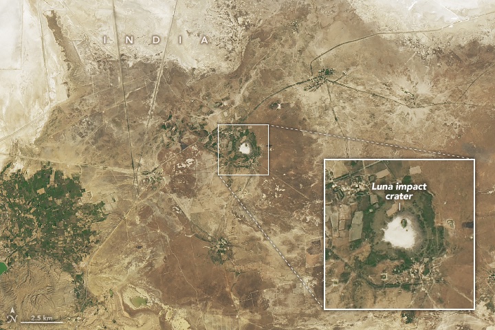
You've heard of Clair de Lune, but what about crater de Luna? 🪨 The #Landsat 8 satellite captured this image of a meteorite impact site—Luna crater—located in India's Gujarat state in the Banni Plains grassland in February 2024. go.nasa.gov/4dfEnFS

New NASA OPERA Land Surface Disturbance Annual from Harmonized #Landsat Sentinel-2 (HLS) Version 1 product available at NASA's #LPDAAC summarizes the DIST-ALERT product into an annual #vegetation disturbance data product. @NASAJPL Learn more: go.nasa.gov/3wcix5j

During a prolonged drought in Spain, wet spring storms flooded marshes, filled temporary ponds, and revived vegetation in the unique habitat of Doñana National Park. 🌧️ These #Landsat images show the area in April of 2023 and 2024. go.nasa.gov/3xLDW5K

Planting a tree for #ArborDay? Our satellites are mapping trees nationwide 🌳 to aid land cover research. This canopy data from @forestservice with #Landsat images is just one layer on the National Land Cover Database supporting environmental research: mrlc.gov/viewer/ 🛰️
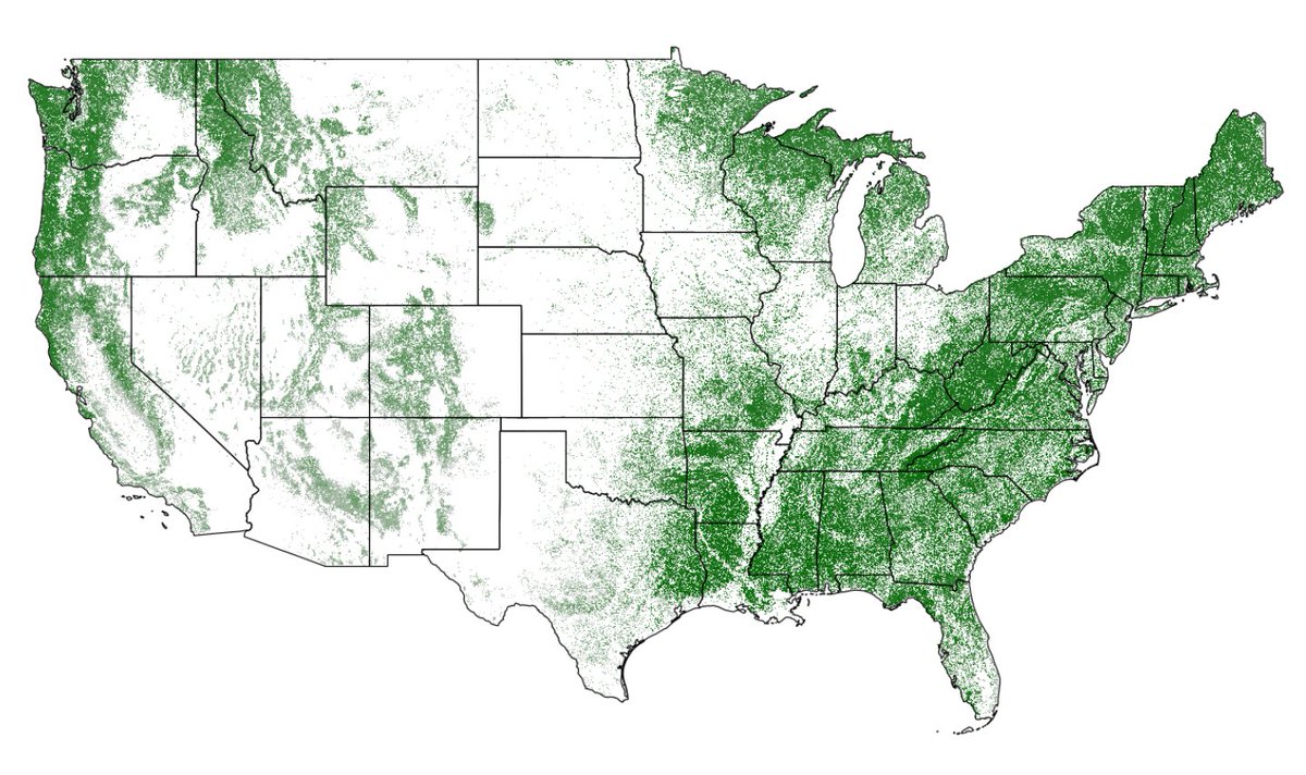
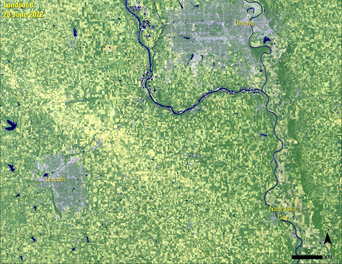
#NationalArborDay celebrates the importance of trees in our environment. Typically, people plant a tree to commemorate the occasion. The holiday began in Nebraska City, Nebraska, on April 10, 1874. This #Landsat image shows the area.
#OTD in 1986, an accident at the #Chernobyl Nuclear Power Plant forced communities to abandon settlements and agricultural land within the region. #Landsat images have captured the lasting impacts of the disaster. Learn more here: ow.ly/qxCL50Rpows
“The spectrum of observations will be more finely divided with the next Landsat satellites; that will allow for even greater and more precise differentiation of the types of land cover on the surface of Earth.” — Jim Irons, @NASAGoddard Emeritus go.nasa.gov/3vTj789

The Landsat archive contains 51 years of changes on Earth, but more data’s on the way. Our latest Eyes on Earth podcast episode describes Landsat Next: 3 satellites, 6-day revisit, 10m resolution, 26 spectral bands … and countless benefits to society. ow.ly/pcqf50RmlAk
In northwest India, a circular feature has attracted curiosity in recent decades. A geochemical analysis of the area revealed it contains the characteristic signatures of a meteorite impact. #Landsat 8 captured an image of the Luna impact crater. go.nasa.gov/3UrWHnJ
Landsat data are available to download at no charge through traditional USGS tools such as EarthExplorer. An Amazon Web Services (AWS) account is required if you prefer to access the data in the cloud, however. Learn more with this FAQ answer: ow.ly/ij9a50Ro0cT.
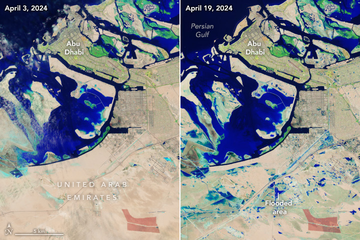
Heavy rain triggered flash flooding across eastern parts of the United Arab Emirates, inundating roads and disrupting transportation. These #Landsat 9 images are infrared-color (bands 6-5-3) to emphasize the presence of water, which appears blue. go.nasa.gov/3xQKwrW

Ice anglers had an unusually short season this year in northern Minnesota. This new Image of the Week offers a Landsat look at the past 10 Februarys to see how 2024 treated Mille Lacs Lake much differently. Find a closer view of the lake’s ice roads here: ow.ly/wsr650Rnamy
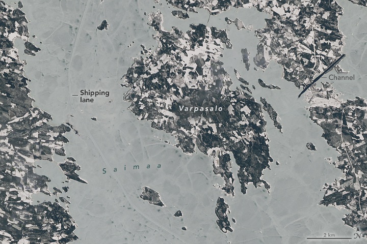
Spanning more than 4,000 square kilometers, Lake Saimaa is Finland's largest freshwater lake. From December to April, the lake remains frozen, but icebreaking ships allow it to be navigable year-round. #Landsat 8 acquired these images on April 9, 2024. go.nasa.gov/49PVVp3

NASA’s Harmonized #Landsat and Sentinel-2 (HLS) project combines data from both satellites to revolutionize earth observation. 🌏 Take a journey through the cutting-edge world of remote sensing and explore the future of monitoring Earth's health with HLS. go.nasa.gov/4aJokyt

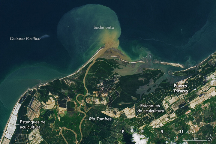
Esta imagen de #Landsat del delta del río Tumbes, en Perú, muestra estanques de acuicultura para la cría de camarones. Estos son importantes para la economía local, pero han contribuido a la reducción de los bosques de manglares: go.nasa.gov/4b91yjl 🦐
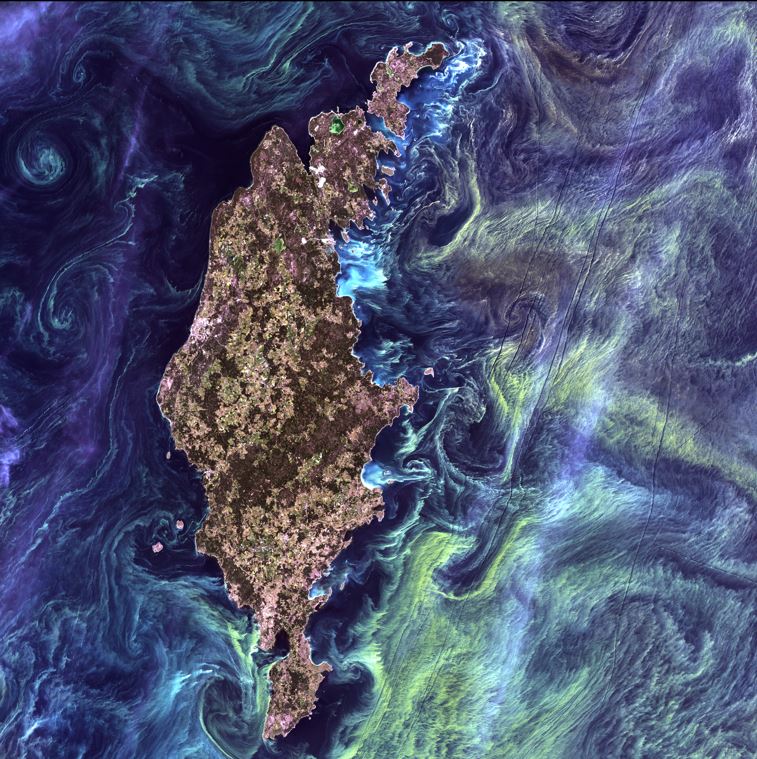
Landsat satellites have been capturing images of the Earth's surface for 50+ years. Not only do they have scientific value, but they're also beautiful to look at (some even resemble famous works of #art). Browse them all ➡️ ow.ly/c1p450RlGTJ #EveryDayIsEarthDay #NASA
The 2024 NASA Earth Day poster is composited with real satellite imagery from NASA's Terra, Aqua, and Landsat missions! 🛰️ Learn more about each of the images used: science.nasa.gov/earth/earth-da…
LANDSAT. The longest continuously running Earth-observing satellite program offers unique views of Earth’s land each day. We celebrate our planet every day from the vantage point of 438 miles above the surface! Check out the Landsat Science Storymap: ow.ly/JxuV50RlpPQ.

Happy #EarthDay! 🌎 Every day, #Landsat takes a #GlobalSelfie! 🛰️ These images of Earth help scientists track changes in land surfaces and water resources from 1972 to the present. Learn more about the Landsat program: landsat.gsfc.nasa.gov


Qiusheng Wu @giswqs
38K Followers 5K Following Associate Professor @UTKGeography | @Amazon Visiting Academic | Senior Reseach Fellow @UNUINWEH | #EarthEngine GDE | Talk about #opensource #geospatial #dataviz
Copernicus EU @CopernicusEU
134K Followers 2K Following The Earth Observation component of the EU Space Programme
ESA Earth Observation @ESA_EO
143K Followers 3K Following @esa #EarthObservation: Taking the pulse of our planet from space. Please see our Privacy Notice: https://t.co/zzMYcxj8xi
USGS Landsat @USGSLandsat
37K Followers 214 Following Official USGS account for the Landsat Program - a series of Earth-observing satellites co-managed by @USGS & @NASA. Imaging the Earth since 1972.📡🛰️
Mike Wulder @mikewulder
13K Followers 7K Following Senior Research Scientist with the Canadian Forest Service. 🍁 #Landsat super-fan. #Lidar. #Forests. #Remotesensing. 🌲🛰 Member of the #OrderOfCanada. 🎖
Remote Sensing MDPI @RemoteSens_MDPI
17K Followers 980 Following No. 1 #remotesensing #openaccess journal in Remote Sensing Category in #WoS, published by @MDPIOpenAccess; IF 2022 5.0; CiteScore 2021 7.9; #mdpiremotesensing
🥔🗺️ ᴘᴏᴋ.. @pokateo_maps
25K Followers 3K Following 👋🏻 I'm Kate ᵉᵃᵗᵉʳ ᵒᶠ ᵖᵒᵗᵃᵗᵒᵉˢ ᵃⁿᵈ ᵐᵃᵏᵉʳ ᵒᶠ ᵐᵃᵖˢ 🌐 I make #geospatial & #GIS (more) fun by sharing #mappymeme s & #maptastic themes. Hosts #GISchat. ᵛᶦᵉʷˢᵐᶦⁿᵉ
NASAEarthdata @NASAEarthData
40K Followers 417 Following Discover NASA Earth science data, information, services and tools. Have questions? [email protected] Verification: https://t.co/yvflidJq6x
NASA's Launch Service.. @NASA_LSP
198K Followers 153 Following ✨Earth's Bridge to Space✨ NASA’s provider of a commercial launch experience, matching spacecraft to launch vehicles since 1998! 🚀 Up Next: GOES-U
Keiko @Keiko_geo
11K Followers 4K Following PhD; VP of Science and Technology @climateengine; GDE @googledevs; #EarthObservation 🌳🌴🛰 #AI; #EarthEngine tips for #BetterFuture🌏; from 🗾; views my own
Robin Cole @robmarkcole
10K Followers 4K Following Tackling the worlds toughest challenges with AI & ML applied to satellite & aerial imagery https://t.co/QmbOWgdfAZ
Planet @planet
258K Followers 4K Following We see things from a different angle. 🛰️🕊️ Public Benefit Corporation on NYSE $PL
Dr Robbi Bishop-Taylo.. @SatelliteSci
8K Followers 6K Following Earth Observation Scientist at @GeoscienceAus. Using satellite data 🛰️ to study the earth 🌍 through space and time
NASA Langley Research.. @NASA_Langley
460K Followers 170 Following The official page of NASA's Langley Research Center. Home to innovation, exploration, and discovery. 🌎✈️🚀 Verification: https://t.co/lPgpn9hhCK
Pierre Markuse @Pierre_Markuse
10K Followers 2K Following Never stop being curious! #RemoteSensing #Sentinel #Landsat some #wx . Sat images on Flickr: https://t.co/429cDFeGh4
Aravind 🌍 🛰 @aravindEO
7K Followers 1K Following Founder, @terrawatchspace Advisory & Insights | Earth Observation Consultant, Strategist & Communicator | Demystifying Satellite Data & its Applications 🌍 🛰️
Joshua Stevens @jscarto
15K Followers 1K Following Cartographic Editor @mapsdotcom & Content Strategy @Esri. Prev: DataViz Lead @NASAEarth, @NSF PhD Fellow @PSUGeography. Dad stuff everywhere else. Views my own.
USGS EROS @USGS_EROS
7K Followers 158 Following USGS Earth Resources Observation and Science Center. The changing face of your planet: documented, studied & shared since 1973. Questions: [email protected]
Copernicus EMS @CopernicusEMS
68K Followers 2K Following Copernicus Emergency Management Service provides mapping products based on satellite imagery as well as #ForestFires #Flood and #Drought early warning products.
Sisters of SAR @SistersofSAR
10K Followers 4K Following A passion for all things #SAR | #WomeninSAR | @eoscenefrom | We 💜@LadiesofLandsat & @DamesofDrones| Tweets by @LDR1, @SAR_ahBanks, @Go__Pika & @ant_dasgupta |
YHWH @YHWH_Sabaoth
24 Followers 209 Following Welcome to the official X account of the almighty God, Creator and Master of the Universe.

Remo Carrer @CarrerRemo42083
15 Followers 145 Following
Ashim Das @limitless_ash_
1 Followers 243 Following

Tyler LaBranche @tylerjl03221996
47 Followers 1K Following
Mustafa Akdeniz @mustafa_akdnz
5 Followers 4K Following
XueEr @XueEr0000
69 Followers 1K Following
prashant kuntala @prashkuntala
192 Followers 1K Following Computational Biology PhD Candidate in Ting Wang's lab @twang5 @WUSTLdbbs. Studying epigenetics of Exceptional Longevity & OMICs Data Visualization
Janie Mendez @MendezJani54777
0 Followers 4 Following
Shabbir Ahammed Princ.. @shabbirahammedp
21 Followers 486 Following
nicholas woodall @nickwoodall1976
802 Followers 5K Following

luis reyes @lumpareza
0 Followers 38 Following

fangedj420 @IgnitedSpringt4
64 Followers 154 Following
Safae El Herraz @SafaePresse
501 Followers 3K Following Journalist Medi1 TV & Radio, Responsable d'opérations et coordination @medi1 MA in media & communication Fellow of the Bridge program investigative journalism
UDENE @UDENE_Project
15 Followers 55 Following Providing urban planners and visionaries with an innovative environment for research and natural experiments.
Idris Muhammad Kabir @imkabir487
1 Followers 38 Following Civil Engineer with Geographical Information System and Remote Sensing Background

basil debs @DebsBasil23168
1 Followers 85 Following
Conner Boyd WX @ConnerBoyd_WX
337 Followers 2K Following NWS Morristown Strom Spotter/Born in Kingsport TN/DB-EXCEL Student/CHMS Grad 2021/Loves my Family & Friends/Lover to God Etc...
Радослав @smilyfaceguy43
3 Followers 117 Following
Steve Fesperman @fesperman_steve
156 Followers 1K Following
Oguzhan Kose @oguzhan_koseo
1 Followers 100 Following Geomorphologist, Geospatial analysis & Data visualisation
Ishigami Senku @Ishigamisenku41
21 Followers 202 Following
ali fakhri @alifakhri5
7 Followers 32 Following
Gadanga @hydaradda
167 Followers 695 Following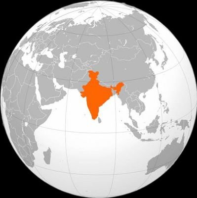
स्वतंत्.. @news_free9
502 Followers 4K Following geopolitics। indian politics। association of sports। research। national science। defence colony।
GK @kimguan18
60 Followers 887 Following
Bruce Walker Nelson @B_Nelson_Manaus
764 Followers 467 Following #INPA, Environmental Dynamics. Tweets are my own.
ミツバチof山梨 @kanran20240212
3 Followers 29 Following 自然の移ろいと気象の姿🌳🌸山梨から🍁にわか気象予報士が😉気ままに☕ツイートします🖍 #自然 #気象 #山梨

Arnob Chakraborty @arnobchak
463 Followers 5K Following Youtuber, Podcaster, IWC | Followed by John Cena, SGT Slaughter | I love Badminton
dr. Kesayanganmu ❁ @TradeInves
3K Followers 4K Following MD🥼💉⚕️ | ♒️ | 🇮🇩 | Primum non nocere | Fortis Fortuna Adiuvat | Kalo DM, to the point, utarakan mau apa
The National Weather .. @natwxdesk
2K Followers 224 Following Connecting you with awesome weather content from Sinclair's meteorologists across the country and from our viewers using Chime In. @natwxdesk #WowWeather
Andrés Cardona @andres_cardon7
235 Followers 2K Following En este perfil somos un remix musical. Acá decimos pamdebono y chuspa.
Samuel Pavlovkin @SPavlovkin
0 Followers 53 Following
wartyx @wartyx753101
1 Followers 88 Following
HUA Earth Observation.. @huaeoteam
5 Followers 54 Following •Research team specialized in Remote Sensing applications 🛰️ •Department of Geography, Harokopio University of Athens 🌍

Randy Carr @randy32087
24 Followers 84 Following
Spade🚭 @OKijiko72517
0 Followers 13 Following
Canopus @Canopus2424
14 Followers 176 Following
alfonzleon110 @alfonzleon110
73 Followers 1K Following «Quien controla el presente controla el pasado y quien controla el pasado controlará el futuro.» Orwell. cuenta anterior suspendida.
K.V. Satish @ecosatish
46 Followers 259 Following 🛰️🌍 🇮🇳 Researcher | Ecology | Biodiversity & Conservation | Remote Sensing | Ecological Modelling | Banner map source: FAO
spes.vita @juys777
175 Followers 2K Following
Jhonatan Arias @jaariaszIQ
59 Followers 1K Following
Mattew Leroy @MattewLeroy
2 Followers 24 Following
Copernicus EU @CopernicusEU
134K Followers 2K Following The Earth Observation component of the EU Space Programme
ESA Earth Observation @ESA_EO
143K Followers 3K Following @esa #EarthObservation: Taking the pulse of our planet from space. Please see our Privacy Notice: https://t.co/zzMYcxj8xi
USGS Landsat @USGSLandsat
37K Followers 214 Following Official USGS account for the Landsat Program - a series of Earth-observing satellites co-managed by @USGS & @NASA. Imaging the Earth since 1972.📡🛰️
Remote Sensing MDPI @RemoteSens_MDPI
17K Followers 980 Following No. 1 #remotesensing #openaccess journal in Remote Sensing Category in #WoS, published by @MDPIOpenAccess; IF 2022 5.0; CiteScore 2021 7.9; #mdpiremotesensing
NASAEarthdata @NASAEarthData
40K Followers 417 Following Discover NASA Earth science data, information, services and tools. Have questions? [email protected] Verification: https://t.co/yvflidJq6x
NASA's Launch Service.. @NASA_LSP
198K Followers 153 Following ✨Earth's Bridge to Space✨ NASA’s provider of a commercial launch experience, matching spacecraft to launch vehicles since 1998! 🚀 Up Next: GOES-U
Planet @planet
258K Followers 4K Following We see things from a different angle. 🛰️🕊️ Public Benefit Corporation on NYSE $PL
Joshua Stevens @jscarto
15K Followers 1K Following Cartographic Editor @mapsdotcom & Content Strategy @Esri. Prev: DataViz Lead @NASAEarth, @NSF PhD Fellow @PSUGeography. Dad stuff everywhere else. Views my own.
USGS EROS @USGS_EROS
7K Followers 158 Following USGS Earth Resources Observation and Science Center. The changing face of your planet: documented, studied & shared since 1973. Questions: [email protected]
Copernicus EMS @CopernicusEMS
68K Followers 2K Following Copernicus Emergency Management Service provides mapping products based on satellite imagery as well as #ForestFires #Flood and #Drought early warning products.
Sisters of SAR @SistersofSAR
10K Followers 4K Following A passion for all things #SAR | #WomeninSAR | @eoscenefrom | We 💜@LadiesofLandsat & @DamesofDrones| Tweets by @LDR1, @SAR_ahBanks, @Go__Pika & @ant_dasgupta |
Zhe Zhu 🌎🛰️ @GERSLab
4K Followers 1K Following Associate Professor @UConnNRE, Director of Global Environmental Remote Sensing Laboratory, USGS-NASA Landsat Science Team, Associate Editors of RSE, SRS, & JRS.
NASA Armstrong @NASAArmstrong
440K Followers 107 Following The Armstrong Flight Research Center is NASA's primary center for atmospheric flight research & operations. Verification: https://t.co/tGaWFbUskp
Ladies of Landsat @LadiesOfLandsat
12K Followers 5K Following ALL are welcome! | #STEMinism | We 💜 @SistersofSAR, @WomenofWaves & @DamesofDrones! | Website coming soon!
Sentinel Hub @sentinel_hub
39K Followers 472 Following A geospatial developer platform for EO data. Now a part of @Planet.
NASAARSET 🛰🌎 @NASAARSET
15K Followers 333 Following NASA's Applied Remote Sensing Training (ARSET) program empowers the global community through remote sensing training. Verification: https://t.co/wDGYeUYaMM
NASA Space Communicat.. @NASASCaN
85K Followers 253 Following Official Twitter account of NASA's Space Communications and Navigation (SCaN) Program. Exploration, enabled. Verification: https://t.co/hMAIsDc0Xa
Integrated RS Studio @IRSS_UBC
4K Followers 2K Following The Integrated Remote Sensing Studio at the Faculty of Forestry @ubcforestry of UBC @ubc, led by Prof Nicholas Coops 🇨🇦 🇳🇿
Radiant Earth @OurRadiantEarth
8K Followers 1K Following Increasing shared understanding of our world by expanding access to geospatial data and machine learning models.
Esri Training @EsriTraining
33K Followers 1K Following Advancing geospatial capabilities of individuals, teams, and organizations is our mission and our passion.
Library of Congress @librarycongress
1.2M Followers 12 Following Official account of the world’s largest library. Explore collections & plan a visit. All Library accounts: https://t.co/KMH2LPXfZv
Daily Overview @DOverview
16K Followers 130 Following Showing Earth from above to inspire the Overview Effect. Check out our website to learn more.
International Space S.. @Space_Station
8.3M Followers 183 Following NASA's page for the latest updates from the International Space Station. For the newest science, follow @ISS_Research. Verification: https://t.co/jSJ1pgS2xl
NASA Space Operations @NASASpaceOps
17K Followers 81 Following The Space Operations Mission Directorate enables sustained human exploration missions & operations in low Earth orbit. Verification: https://t.co/jG2H03eMpA
Dr. Nicky Fox @NASAScienceAA
9K Followers 201 Following Rocket Scientist. Pioneer. Explorer. @NASA Science Associate Administrator Verification: https://t.co/T6wcbljmdB
National Academy of E.. @theNAEng
27K Followers 1K Following The National Academy of Engineering advances the welfare of the nation by providing independent advice on matters involving engineering and technology.
NASA Space Place @NASAspaceplace
95K Followers 300 Following NASA Space Place engages and inspires kids online with games, activities and articles.
USGS Minerals @USGSMinerals
13K Followers 200 Following Unbiased science & information on mineral resource potential, production, consumption, & the environment. Tweets do not = endorsement: http://t.co/BMEMunSMXo
Nat Geo Education @NatGeoEducation
189K Followers 2K Following Where education meets exploration. #ExplorerMindset
NASA EPDC @NASAEPDC
2K Followers 550 Following The NASA STEM Educator Professional Development Collaborative is a project led in collaboration with Texas State University.
Glacier Bay NP @GlacierBayNPS
78K Followers 356 Following Glacier Bay is a vast wilderness of mountains, glaciers, forests, and waterways teeming with wildlife & opportunities for adventure. RT/follow/likes≠endorsement
Women in Copernicus @WomenCopernicus
3K Followers 2K Following #WomeninCopernicus - A European action to identify & give a voice to the women working on 🇪🇺 #Copernicus #EarthObservation #space 📺 https://t.co/WMOOlfTp3e
UNStats @UNStats
34K Followers 211 Following Official Twitter account of the Statistics Division of the United Nations Department of Economic and Social Affairs.
USGS South Atlantic W.. @USGS_SAWSC
424 Followers 91 Following USGS South Atlantic Water Science Center (SAWSC) - GA, NC, and SC. Tweets do not = endorsement https://t.co/elqlXCwDPF (Contact: https://t.co/SsBDEbc7k6).
U.S. Fish and Wildlif.. @USFWS
316K Followers 38K Following The U.S. Fish and Wildlife Service (USFWS) is dedicated to the conservation, protection, and enhancement of fish, wildlife, plants, and their habitats. 🐟🦆 🌱
SERVIR Amazonia @ServirAmazonia
539 Followers 253 Following Funded by @USAID Supported by @NASA Implemented by @BiovIntCIAT_eng & serving the #Amazon region mainly with @sig_gis @amazonacca @Imaflora & @F_EcoCiencia
Minds Behind Maps @MindsBehindMaps
2K Followers 1 Following Maps are everywhere; These are conversations with the people building them | Hosted & Produced by @MaxLenormand
CAFMS @APfirescience
1K Followers 240 Following Consortium of Appalachian Fire Managers and Scientists Connecting fire managers and scientists throughout the Appalachian region.
Copernicus Land Monit.. @CopernicusLand
12K Followers 795 Following Copernicus is the European Union's Earth Observation programme. CopernicusLand is one of six thematic services that deliver free and open geospatial products
eos @eo_services
1K Followers 23 Following https://t.co/ZeOIde5iWW is the website of the CERTH/ITI Remote Sensing research team, interfacing Earth Observation live product demos to the public
Royal Conservatoire o.. @RCStweets
27K Followers 4K Following The Royal Conservatoire of Scotland is a World Top 10 destination for performing arts education. (QS World University Rankings 2024)
Geospatial World Risi.. @GW_RisingStars
624 Followers 0 Following An annual list of Rising Stars representing the future of Geospatial industry
Geological Survey/Com.. @GSC_CGC
4K Followers 301 Following Info on Canada’s geology, natural hazards & climate change/ Infos sur la géologie du Canada, les aléas naturels & les changements climatiques
RSPSoc @RSPSoc
2K Followers 487 Following We are the UK’s leading Society for remote sensing and photogrammetry and their application to education, science, research, industry, commerce and the public.
Tanya Trujillo @AsstSecTrujillo
2K Followers 174 Following This is an archived account and is not being updated. Proud to have served @SecDebHaaland as Assistant Secretary for Water and Science of @Interior 2021–2023.
U.S. Department of St.. @SciDiplomacyUSA
25K Followers 775 Following @StateDept's OES Bureau: Working on global environmental, ocean, and space affairs. Tweets from Acting Asst Secretary Jennifer R. Littlejohn signed -JRL
Army Geospatial @ArmyGeospatial
1K Followers 270 Following Official site of the Army Geospatial Center. Providing #USArmy timely, accurate, and relevant geospatial information and capabilities. (F/RT/L ≠ endorsement)
Earth Observation @Un.. @eo_wuerzburg
3K Followers 81 Following Earth Observation Research Cluster (EORC) at University of Wuerzburg, Geography, Germany @Uni_Wue - from UAS to satellite - also bluesky eor-wuerzburg

American Scientist @AmSciMag
32K Followers 841 Following Publishing award-winning science, tech, engineering, & math content for over a century. Join us for daily stories.
Remote Sensing in Eco.. @RSECJournal
4K Followers 161 Following RSEC is open access peer-reviewed journal for novel, multidisciplinary research at the interface between remote sensing science & ecology and conservation
Mapping Africa’s En.. @MAEASaMProject
1K Followers 81 Following Mapping Africa’s Endangered Archaeological Sites and Monuments project funded by @ArcadiaFund
Science Communication.. @scicomm_jc
7K Followers 5K Following Your hub for latest #scicomm research. Team: @NevenaHr @snouraini @HC_Conklin @GlorianaNdibal1 Our podcast https://t.co/qptFMCVbrG
University of Norther.. @UNBC
26K Followers 2K Following The University of Northern British Columbia is Canada's Green University, ranked by Maclean's magazine as one of Canada's top small universities. #ThisIsUNBC
OpenET @openetdata
709 Followers 322 Following Filling the Biggest Data Gap in Water Management Learn more at https://t.co/tSHKMry4kw
REDDCopernicus @REDD_Copernicus
432 Followers 294 Following This project receives funding from the @EU_H2020 Research & Innovation Programme. Any related tweets reflect only the views of the project owner.
ipbes @IPBES
131K Followers 13K Following Intergov. Platform on Biodiversity & Ecosystem Services. @IPBESes, @IPBESfr. Also on: https://t.co/O046oK8MhT RT ≠ endorsements. Denialism/trolling/profanity may = ban.
Coastal & Estuarine R.. @CERFScience
6K Followers 6K Following Advancing understanding & wise stewardship of estuarine & coastal ecosystems worldwide. Tweets do not imply endorsement
NASA Space Science @NASASpaceSci
114K Followers 158 Following Space is one of our many labs. Our experiments help us go farther and stay longer, while also benefiting life on Earth! 🔬 ✨ Verification: https://t.co/c2rT67mM1b
Lake Tahoe USFS @LakeTahoeUSFS
18K Followers 407 Following The Lake Tahoe Basin Management Unit encompasses over 154,000 acres of National Forest lands around beautiful Lake Tahoe! Follows/Likes/RTs Don't = Endorsement
AGU Science & Society.. @AGUSciSociety
360 Followers 32 Following Join our community of artists, policy makers, community members & scientists of all disciplines. SY Section @theAGU. Follow https://t.co/mQD82IUcvK
PGC @polargeospatial
1K Followers 368 Following The Polar Geospatial Center (PGC) provides geospatial support, mapping, & remote sensing solutions to researchers and logistics in the polar science community
NASA Atmosphere @NASAAtmosphere
431K Followers 120 Following NASA studies the atmospheres of our planet and others to better understand weather and climate on Earth – and beyond. Verification: https://t.co/RFkwCpUIHa
NOAA Great Lakes Envi.. @NOAA_GLERL
18K Followers 2K Following Innovative research on the dynamic environments and ecosystems of the Great Lakes. This is an official @NOAA account.
Wyss Academy for Natu.. @Wyss_for_Nature
1K Followers 76 Following Creating a New Relationship with Nature
CRSS / SCT @CRSS__SCT
1K Followers 336 Following Canadian Remote Sensing Society | La Société canadienne de télédétection
MSU Hydrogeology Lab @MSUHydro
689 Followers 299 Following Focused on understanding our water resources and how society can become more sustainable. Led by Dr. Anthony Kendall, but powered by students and technicians!
United States GLOBE @US_GLOBE
514 Followers 328 Following Twitter account for the United States GLOBE Program. Posting and re-tweeting news about what is happening in GLOBE and around the country in GLOBE classrooms!
MIT Technology & Poli.. @TPPMIT
2K Followers 309 Following Technology and Policy Program @MIT. Part of @mitidss @MIT_SCC.
Just in time for #EarthDay! Our latest Eyes on Earth podcast episode describes improvements we’re looking forward to in the Landsat Next mission and how they will benefit the entire planet. Listen here: ow.ly/J5OR50Rla8q

@NASA_Landsat If we HAD to choose, we're going with the Great Bahama Bank!

@NASA_Landsat @NASAClimate All! 🌞🌍🌌🌎🌝🌏
@NASA_Landsat There's no way we could ever pick just one!
#LandsatNext Getting excited for the next #Landsat. 3 satellite constellation to enable increased temporal revisit, higher spatial resolution, and increase in number and diversity of spectral band-passes. Very nice! New factsheet, nice summary of info: usgs.gov/publications/l…


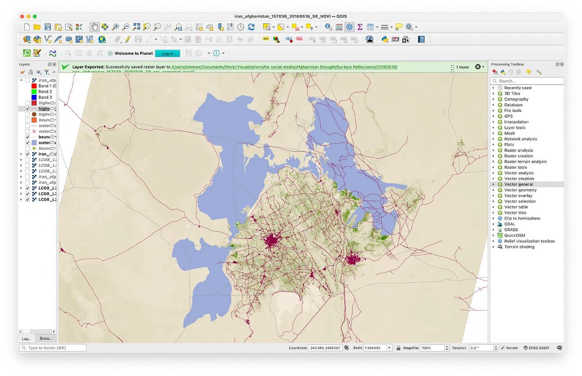
I put together step-by-step instructions for working with Landsat surface reflectance data for a training session, and thought it was worth sharing more broadly: medium.com/@robsimmon/wor… It covers false-color, the raster calculator, and bonus mapmaking with QuickOSM.


Since the launch first #Landsat over 50 years ago, there are only ~8 years with only one sensor in orbit. Continuity plus redundancy & increased revisit. 🛰️💪⏱️ 1972 - 1974: L 1 (MSS) 1975 - 1977: L 1 (MSS), L 2 (MSS) 1978: L 1 (MSS), L 2 (MSS), L 3 (MSS) 1979 - 1981: L 2 (MSS),…


Maximize your mapping potential. 🗺️ Here are 10 ways to get the most out of ArcGIS Living Atlas. esri.social/lcev50R8TyW #Mapping #LivingAtlas

1 scene of LANDSAT ingested to HDDS for event 202404_Flood_RUS #RussiaFloods hddsexplorer.usgs.gov/criteria?event…

📢Big #Landsat, #LandsatNext, news: "Australia plans to commit $207.4 million over four years and ongoing funding to the project, going towards enhancing its satellite ground station facilities in Alice Springs, and supporting advanced new data processing and analytics…

🛰️ Australia and the United States are entering into a new partnership to deliver higher resolution land imaging data more often, with greater reliability than ever. Landsat Next will deliver more data in 1 year than has been delivered in the past 50. 👉 bit.ly/4ap4gAJ

Congratulations to @umdgeography 's Dr. Matthew C. Hansen for receiving the prestigious William T. Pecora Award! His groundbreaking work in satellite remote sensing has reshaped our understanding of land cover change on a global scale ➡ Read more usgs.gov/news/featured-…


👀 New Pub! Thematic accuracy assessment #NLCD 2019 CONUS land cover paper has published! Overall results are consistent with previous NLCD land cover accuracy assessments. Have a look at this research article by Wickham et. al. 2023 to find out more! ow.ly/ROUb50R4U2r

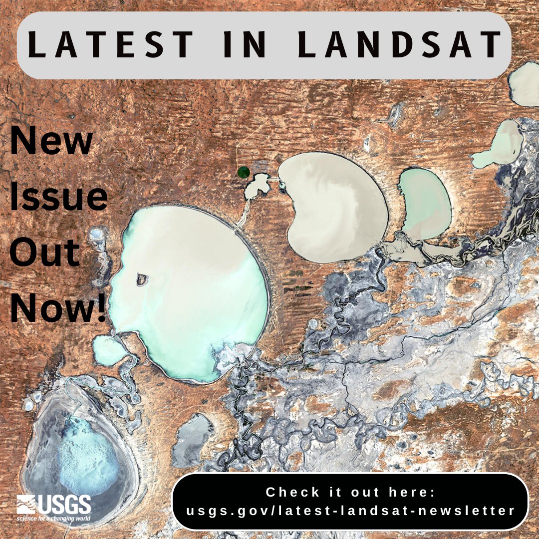
Just posted – a new Latest in #Landsat! March was a busy month with a new Landsat Next factsheet posted and a partnership intention! Landsat Cal/Val published a new report too. Check out the latest issue here: ow.ly/5MoY50R70sJ.

The Landsat Explorer app in ArcGIS Living Atlas of the World provides an easy way for users to access and interpret Landsat satellite data. esri.social/Tqm050R7FbA #LandsatExplorer #ArcGISLivingAtlas #satellitedata #geospatial @katefickas @NASA_Landsat @USGSLandsat

Happy 90th birthday, Jane Goodall! @JaneGoodallInst 🥳
NASA data is helping conserve chimpanzee habitats! The @JaneGoodallInst is partnering with local communities to use Landsat data to map deforestation, monitor habitats, and inform restoration efforts. 🌍 go.nasa.gov/3LmoP70
What if you could search, download, and stream NASA Earth science data using a few lines of code? The earthaccess #Python code library makes this possible by providing easy access to NASA Earth data regardless of the data storage location. Learn more: go.nasa.gov/494NoOY

I called this region the new lake district-red arrows 2001 terminus location, yellow arrows 2019. @NASA_Landsat glacierchange.blog/2019/12/23/ker…

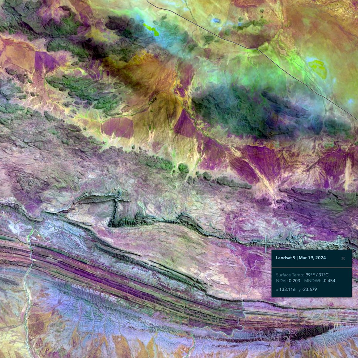
Cook Ice cap, Kerguelen 2017 | 2024 Amazing and rare cloud-free scenes showing tremendous recent retreat of eastern Cook Ice Cap outlets glaciers! ❄️🌞🥵 Ampere Gl. (most studied, south) has properly dislocated! 😱 2024 scene is from today! ⌚️ Source @cms_adrien @CopernicusEU

Explore the world through the lens of Landsat #imagery with ArcGIS Living Atlas! Read this article to discover how this tool empowers users with valuable insights into Earth's changes and environmental trends 🌍 esri.social/YkLq50R4LPq

Trends for United States
You might like