Search results for #Landsat
🔴⚠️🌀⛈🇺🇸Aftermath of the destructive #Tornado hitting #Elkhorn and surroundings on April 26 when #Nebraska was slammed by multiple #storms & tornado. The #Landsat 9 animation shows the effects of the tornado and highlight its path through land. #USA #weather #ClimateEmergency
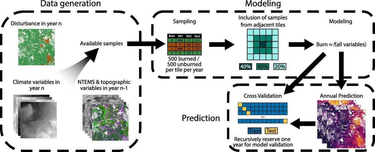
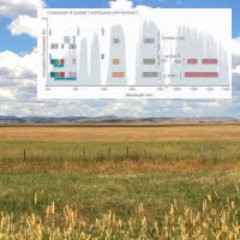
Where & how much #wildfire can be expected?🌲🔥 We use #timeseries #Landsat, #climate, biotic & topographic predictors to model. Mulverhill et al. Multidecadal mapping of status and trends in annual burn probability over Canada’s forested ecosystems. 🔗sciencedirect.com/science/articl…
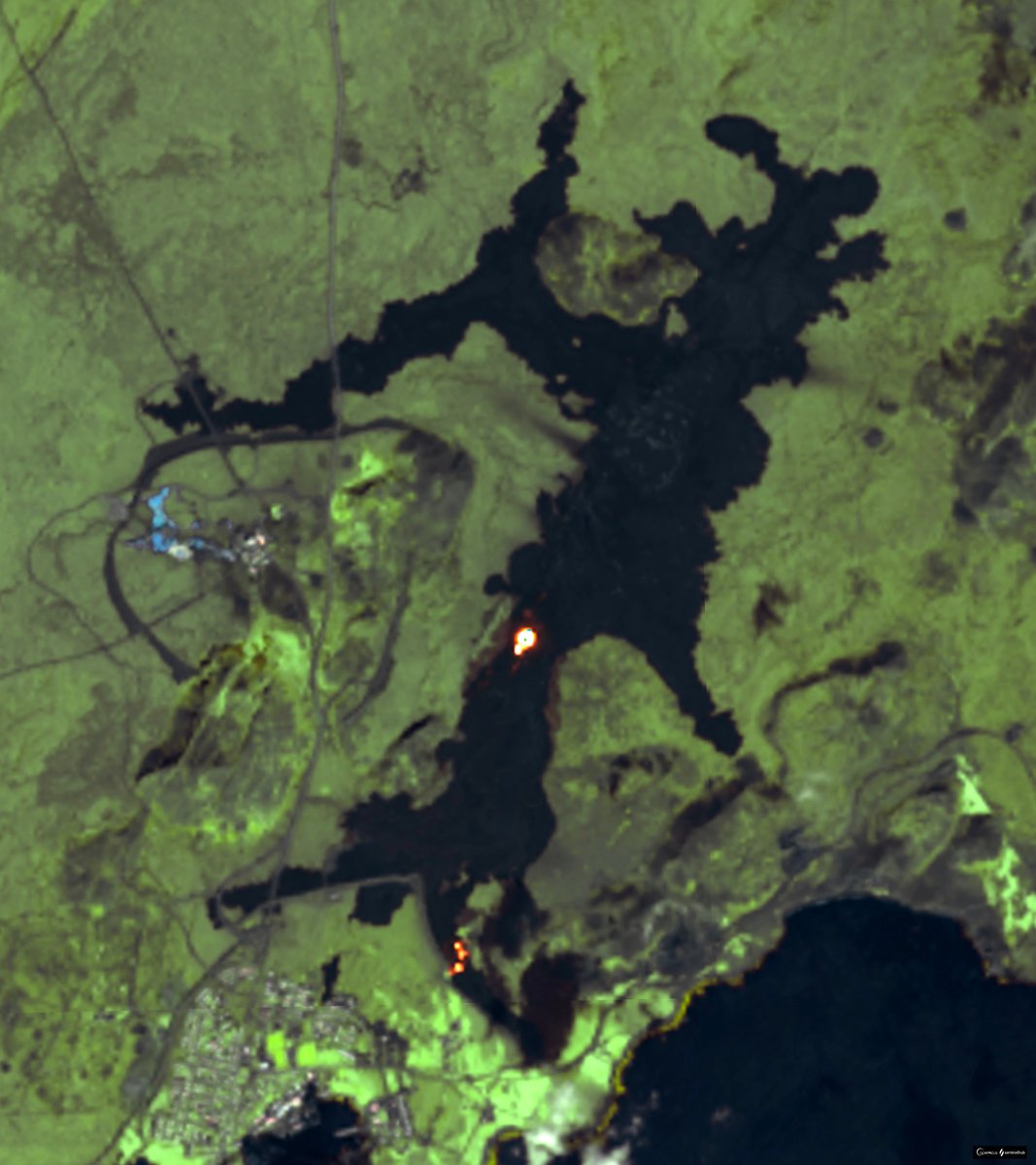
Today's view of #Sundhnúkur eruption in #Reykjanes Peninsula. Lava is still moving south along protective wall, but the flow appears to be weaker. Image taken by #Landsat-8/9. Data processed in @sentinel_hub @CultureVolcan @volcaholic1 #Iceland #volcano

Global view 04/29-30 real-time #Landsat 8 and 9 LOOK Natural Color orbit swaths. Use this link to view hi-res imagery along the swath paths-> re.ssec.wisc.edu/s/h2ZG5S #RealEarth™ #UWSSEC #UWCIMSS @SSECRealEarth
Southern Romania has become tinged with yellow as rows of rapeseed and canola plants have bloomed. 🌼 #Landsat 8 captured these pops of color near the confluence of the Olt and Danube rivers on April 12, 2024. go.nasa.gov/4djDOut


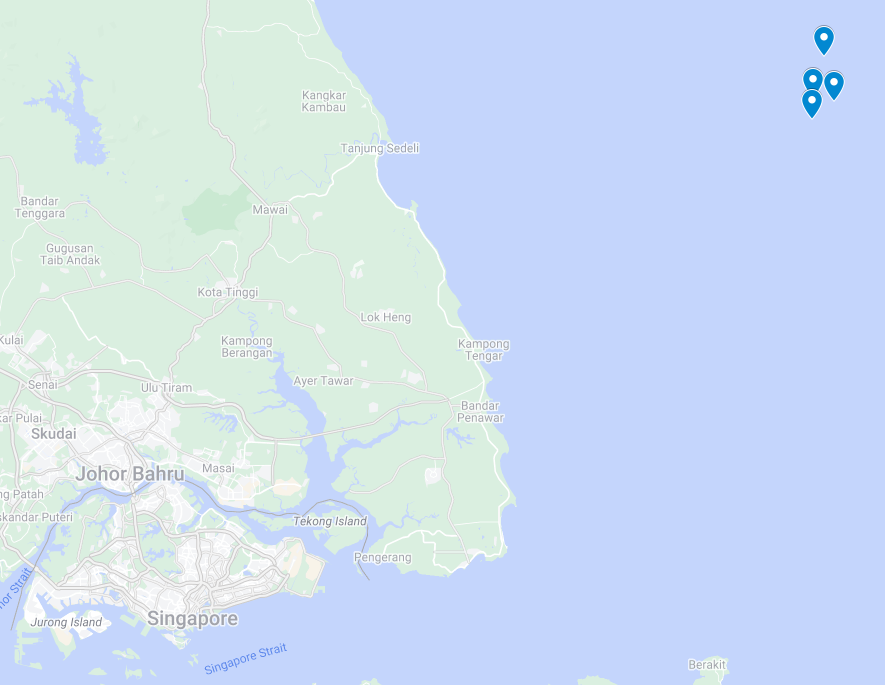
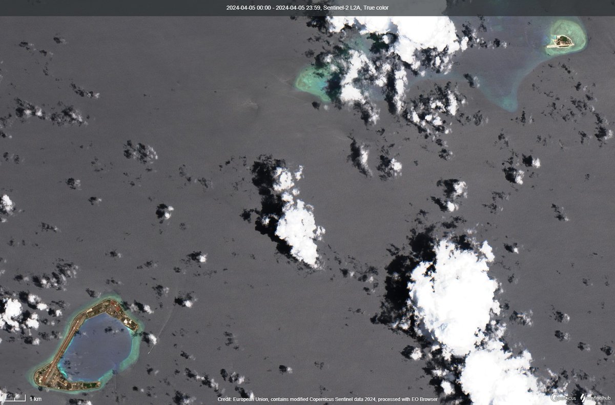
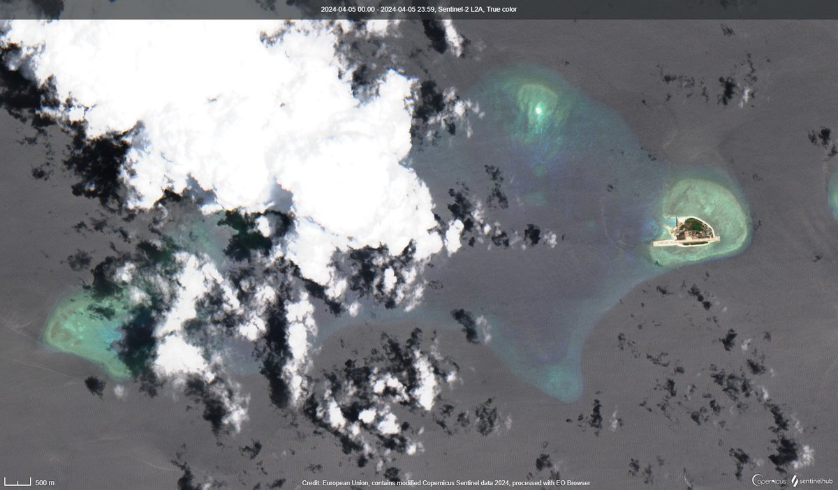
#LANDSAT 🛰️📷30 APR At least 7⃣ Ship-to-Ship (StS) ops observed ~70km offshore Eastern Johor 🇲🇾 in #SouthChinaSea #DarkFleet ops here every day Spoofing AIS, too Another accident just a matter of time @TankerTrackers @claire_jungman @raylockman @d_viekass @johny2b @imosint


#LANDSAT 🛰️📷30 APR At least 7⃣ Ship-to-Ship (StS) ops observed ~70km offshore Eastern Johor 🇲🇾 in #SouthChinaSea #DarkFleet ops here every day Spoofing AIS, too Another accident just a matter of time @TankerTrackers @claire_jungman @raylockman @d_viekass @johny2b @imosint https://t.co/McPKYGupY6


Aftermath of previous eruption of #Ruang #volcano. Images taken by #Landsat-8/9 before and after show multiple pycoclastic flow tracks radiating out from the summit area. #Indonesia #volcano #Ruangvolcano x.com/kosmi64833127/…
Aftermath of previous eruption of #Ruang #volcano. Images taken by #Landsat-8/9 before and after show multiple pycoclastic flow tracks radiating out from the summit area. #Indonesia #volcano #Ruangvolcano x.com/kosmi64833127/… https://t.co/U7hTMqiLxx
[2/2] Aftermath of previous outburst. Images taken by #Landsat-8/9 in January and yesterday. Data processed in @sentinel_hub

Attending #AGU #WaterSciCon24? Don’t miss out on this #USGS workshop about the #Landsat Collection 2 Provisional Actual #Evapotranspiration (ETa) Science Product. Learn how to acquire and work with on-demand ETa data. More about the workshop here: ow.ly/AtS150RqLxx

Late on April 16, 2024, Ruang, a small volcanic island in Indonesia, unleashed a series of eruptions that, at times, sent plumes of gas and ash into the stratosphere. This pair of #Landsat images highlights how the eruption transformed the landscape. go.nasa.gov/3U4Wsxm


Global view 04/28-29 real-time #Landsat 8 and 9 LOOK Natural Color orbit swaths. Use this link to view hi-res imagery along the swath paths-> re.ssec.wisc.edu/s/O2ZCu9 #RealEarth™ #UWSSEC #UWCIMSS @SSECRealEarth

🛰️JFR new publication on #Landsat #Forest #RemoteSensing #Afforestation Assessing forest cover changes and fragmentation in the Himalayan temperate region: implications for forest conservation and management @AqilTariq doi.org/10.1007/s11676…
For more than a decade, Spain’s Doñana National Park has received below-average rainfall, leading to drought in the area. #Landsat 8 & 9 acquired images before & after heavy rains brought relief to the park, flooding marshes and reviving vegetation. go.nasa.gov/49Of7U1


𝐎𝐩𝐞𝐧 𝐏𝐥𝐨𝐭𝐬 𝐚𝐭 𝐏𝐫𝐚𝐠𝐧𝐚𝐩𝐮𝐫, 𝐊𝐚𝐫𝐢𝐦𝐧𝐚𝐠𝐚𝐫 𝐇𝐢𝐠𝐡𝐰𝐚𝐲 𝐇𝐲𝐝𝐞𝐫𝐚𝐛𝐚𝐝| Call Now More Details: 9059333545 #realtynext #RealEstate #Hyderabad #flats #investment #property #Reels #Trending #famous #landofthelustrous #Landsat #Telangana #buyingconent


You've heard of Clair de Lune, but what about crater de Luna? 🪨 The #Landsat 8 satellite captured this image of a meteorite impact site—Luna crater—located in India's Gujarat state in the Banni Plains grassland in February 2024. go.nasa.gov/4dfEnFS

#LANDSAT 🛰️📷27 APR Subi Reef & Thitu (Pag-asa) Island 🇨🇳vessels arriving at Thitu @d_viekass @jaytaryela @OfficialBen_L

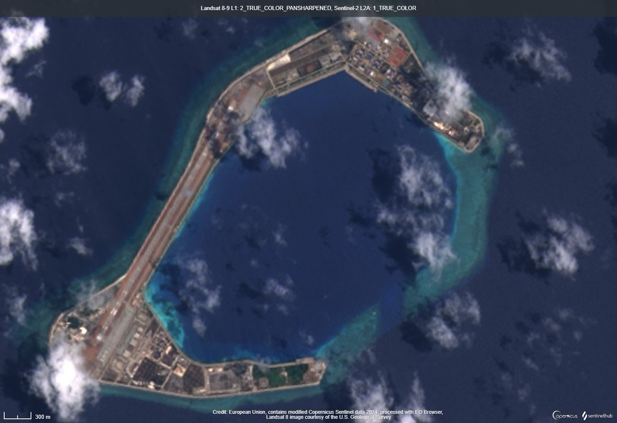

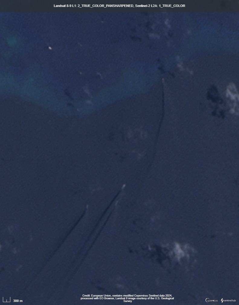
#LANDSAT 🛰️📷27 APR Subi Reef & Thitu (Pag-asa) Island 🇨🇳vessels arriving at Thitu @d_viekass @jaytaryela @OfficialBen_L https://t.co/7nZ0eGC5mg

Open plots at Kadthal Town, Srisailam Highway, Hyderabad Call Us Now For More Details: 9059333545 #realtynext #RealEstate #Hyderabad #flats #investment #property #Reels #Trending #famous #landofthelustrous #Landsat #Telangana #buyingconent #investing


NASA Landsat @NASA_Landsat
80K Followers 470 Following The NASA/USGS Landsat series of Earth-observing satellites has monitored our planet for over 50 years. Verification: https://t.co/4p9BhINXeQ
Landsat Bot @LandsatBot
3K Followers 3 Following I'm a bot that tweets images from the NASA/USGS Landsat program. Managed by @mewo2.
USGS Landsat @USGSLandsat
37K Followers 214 Following Official USGS account for the Landsat Program - a series of Earth-observing satellites co-managed by @USGS & @NASA. Imaging the Earth since 1972.📡🛰️
Ladies of Landsat @LadiesOfLandsat
12K Followers 5K Following ALL are welcome! | #STEMinism | We 💜 @SistersofSAR, @WomenofWaves & @DamesofDrones! | Website coming soon!
Landsat365 @landsat365
860 Followers 87 Following Making beautiful satellite images from Landsat 8. One image crafted and shared each day in 2017. Not @usgs @nasa associated. Images are #CCBYNC
Ball Landsat @Ball_Landsat
41 Followers 5 Following
landsat @soner_gul84
53 Followers 55 Following
社長!毎月が南.. @landsat24
1K Followers 2K Following 2009年から始めた毎月が南の島。2020年12月で丸12年となったが、2021年もつづく?14年目となる2022年、本当に毎月行くのだろうか?←2023年もつづいている😆
Remote Pixel @RemotePixel
3K Followers 93 Following Making Earth Observation available to everyone #Landsat #MODIS #VIIRS #Sentinel #Webmapping #OpenData
Landsat ICT Solutions @LandsatICT
11 Followers 16 Following Landsat ICT Solutions (LICTS) is an Information and Communication Technology (ICT) consultancy and development company
Hillside Farms @LandsatHillside
155 Followers 134 Following Historic, 412-acre non profit educational dairy farm. Northeastern Pennsylvania.
LandSat @123bucephalus
8 Followers 15 Following


you1126 @Rb3qzWR5AK5nooA
9K Followers 100 Following Sentinel-1,2やLandsat-8,9で見たウクライナ情勢について呟いていきたいと思います。
L4NDSAT @landsat4
35 Followers 31 Following Lomba Lintas Alam dan Survey Aplikasi Pemetaan Se-Jawa Barat , more info follow us or CP : 082129068968
Justin Braaten @jstnbraaten
7K Followers 2K Following DevRel for @google #EarthEngine Interested in #Conservation #Landsat #EO #TimeSeries #DataViz
Pierre Markuse @Pierre_Markuse
10K Followers 2K Following Never stop being curious! #RemoteSensing #Sentinel #Landsat some #wx . Sat images on Flickr: https://t.co/429cDFeGh4
kosmi 🛰️🌍 @kosmi64833127
4K Followers 530 Following I'm posting various satellite images, mostly Sentinel and Landsat. I hate putins and i'm proud of it.
Hezbolah @Landsat16
210 Followers 811 Following تا کفر و ظلم هست مبارزه هست و تا مبارزه هست ما هستیم. امام خمینی ره
W🇦🇶🛰️ @WBigNews
10K Followers 1K Following ✨أقوم بنشر صور الأقمار الصناعية المختلفة، معظمها من Sentinel وLandsat.
染川憲一 @landsat200
2 Followers 130 Following
Antarctic Places Bot .. @AntarcticPlaces
223 Followers 57 Following I am a bot that tweets Landsat images of places in Antarctica from the SCAR gazetteer. 🤖 ❄ I am maintained by @agrinsted, and based on @dailyglacier code. ❄
Land Satellite Techno.. @LandsatTech
2 Followers 8 Following We build next gen solar security systems. Starting at $799/month: 👀 24/7 live monitoring 🤖 autonomous operation 🔊 loud sirens & lights 📹 360° FoV and zoom
Mike Wulder @mikewulder
13K Followers 7K Following Senior Research Scientist with the Canadian Forest Service. 🍁 #Landsat super-fan. #Lidar. #Forests. #Remotesensing. 🌲🛰 Member of the #OrderOfCanada. 🎖
Landsat GIFs @LandsatGIFs
2 Followers 1 Following

caixian @landsat01
1 Followers 45 Following
Landsat GIFs @LandsatGIF
4 Followers 5 Following Landsat time series animated GIFs smoothed by LandTrendr spectral-temporal segmentation

Landsat Outdoor Rent @landsatrent
7 Followers 76 Following Rental peralatan camping, hiking, outdoor n adventure buat kamu, iya..kamu 082337840342 / WA & LINE 085755566226 / IG @landsatrent / FB landsatrent
Landsat Mapper @LandsatM
47 Followers 218 Following Proud Suppliers Of Landsat 5 TM Satellite Image Data, Landsat 7 ETM Satellite Image Data & Landsat 8 LDCM Satellite Image Data.
Zhe Zhu 🌎🛰️ @GERSLab
4K Followers 1K Following Associate Professor @UConnNRE, Director of Global Environmental Remote Sensing Laboratory, USGS-NASA Landsat Science Team, Associate Editors of RSE, SRS, & JRS.
Landsat @Landsat202
46 Followers 69 Following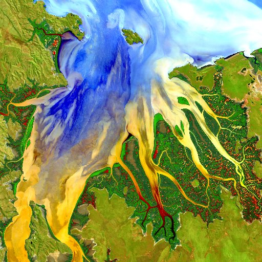
leo lymburner @lymburner74
1K Followers 2K Following Director of Product Development at #DigitalEarthAU at Geoscience Australia, Member of the #Landsat science team
LANDSAT SURVEYORS & E.. @LandsatL
44 Followers 272 Following Land Surveying and Engineering consulting at its best TEL: +256758047931 Email: [email protected]
Dr. Joanne C. White @Joanne_C_White
3K Followers 2K Following Research Scientist @PFC_CFS @NRCan | Adjunct Prof @ubcforestry | Alum @helsinkiuni | #forests #forestinventory #lidar #Landsat #CFSEFI #remotesensing 🌲🛰️
Landsat Processor @ProcessLandsat
8 Followers 0 Following
LANDSAT - Biophilic S.. @LANDSAT_JAPAN
34 Followers 141 Following バイオフィリック・デザインとは直接的な自然、間接的な自然、および空間と場所の条件を使用し自然環境への接続性を高めるために使用される概念です。都市に健康、環境、および経済的利益をもたらし欠点はほとんどないと言われています #LANDSATJAPAN は自然に学び、社会に新たな価値をインストールしていきます
landsat.x @XLandsat
1 Followers 1 Following
david frantz @d__frantz
1K Followers 862 Following Asst. Prof. for Geoinformatics - Spatial Data Science @TrierUni #Landsat #Sentinel2 #FORCE_EO #datascience #openscience

SatelliteImagery360 @1GeoSage
874 Followers 738 Following Developing advanced image analysis methods & global imagery basemaps; promoting easy-to-use image fusion software for Landsat-8 & Sentinel-2 imagery, NDVI etc.
Landsat Surveyors & E.. @LandsatLtd
1 Followers 3 Following
CGAT UPV @CGAT_UPV
415 Followers 338 Following The Geo-Environmental Cartography and Remote Sensing Group of @UPV. #remotesensing #lidar #landsat #sentinel2 #landcover
ImToONE @landsat8oli
0 Followers 20 Following
Landsat-Dummy @LandsatDummy
39 Followers 26 Following Todo sobre Sistemas de Información Geográfica y Sensores Remotos http://t.co/45JUS9oFnR http://t.co/cKn59RvNmk
TheRealSnapsat @TheRealSnapsat
121 Followers 75 Following Create Landsat composites from your browser.
Lachlan Hurst @lachlanhurst
473 Followers 507 Following Engineer, software developer, cyclist and indie dev. Currently working on ObservedEarth, an iPhone and iPad app for processing Landsat data.
Mace @itsokmace
196 Followers 186 Following director @ Landsat Management, administrator @Badimo - previously worked for @ClickerSim1 , @BuildIntoGames , @RumbleStudiosRB, @FreeHatchers, @ActiveWizardRBX
C Russell @RhoRidgeRuss
2K Followers 2K Following Earthling, writer, co-author Landsat’s Enduring Legacy: Pioneering Global Land Observations from Space. Hydrophilic.

Landsat @Landsat18
0 Followers 7 Following
Christopher McGinty @cmcginty
873 Followers 938 Following Geospatial scientist in ecology, remote sensing, Landsat, UAS, beekeeper, backcountry skier, outdoor explorer. Executive Director at AmericaView.

Cam @camhouser
405 Followers 911 Following PhD in Forestry @VTFREC and remote sensing @rs_igep. Interests include #forests, #ecosystems, #ET, #lidar, #thermal, #Landsat , #rstats and #cats
Michael R. Cassidy @MRCfmFBC
994 Followers 2K Following Fire Chief/Emergency Management Director, Youth Worker, Board Member, NASASocial (STS135HQ, Landsat, ISS Research and SRRbot) alum. RT, ♥ ≠ endorsement
Landsat @Landsat22
0 Followers 1 Following

LANDSAT Kasuga @LandsatK
0 Followers 1 Following


landsat @landam_sky
2 Followers 2 Following
Ginger Butcher @echothebat
62 Followers 154 Following Science Communicator, Artist, Maker, and total geek about all things Landsat.
Patrick @Landsat9
1 Followers 0 Following
landsat @landsat2
2 Followers 2 Following
Гарбо @landsat857
0 Followers 0 Following
landsat @landsat5
1 Followers 12 Following
Гарбо @landsat578
0 Followers 0 Following
ランドサット @landsat777
0 Followers 0 Following
لمسات @Landsat82
1 Followers 66 Following
moonlight @landsat8
6 Followers 6 Following
Landsat @Landsat19
0 Followers 0 Following
landsat @landsat1
0 Followers 0 Following
ランドサット @landsat147
0 Followers 0 Following
landsat 6 Rip @6Landsat
0 Followers 28 Following
Landsat @Landsat20
0 Followers 6 Following
Landsat @Landsatgo
0 Followers 0 Following
landsatX @LandsatX
0 Followers 0 Following
landsat-next @NextLandsat
0 Followers 0 Following
landsat @landsat1134199
0 Followers 1 Following
nishimura kazutaka @landsat723
0 Followers 1 Following サッカーが好きで、よくヴィッセル神戸の試合を観に行ってます。最近のお気に入りは、バイク乗りなので、アーミーファッションにはまっています。どうぞよろしく。
بسم الله ال�.. @landsat4562
0 Followers 7 Following
الخليل علوي @Landsat6
0 Followers 0 Following
Landsat morad @MoradLandsat
0 Followers 20 Following
بسم الله ال�.. @landsat456
0 Followers 10 Following
ابراهيم مهن.. @landsat789
0 Followers 0 Following
Landsat @Landsat17
0 Followers 2 Following
あああ @landsat12345
1 Followers 67 Following
斎藤 拓 @landsat10
0 Followers 0 Following
あきひろ @landsat1182
0 Followers 2 Following