Geoff Zeiss @gzeiss
Geoff tracks the contribution of geospatial technology to the digitalization of the construction and energy industries on his Between The Poles blog. geospatial.blogs.com Ottawa, Ontario, Canada Joined March 2009-
Tweets3K
-
Followers1K
-
Following319
-
Likes203
Gopher State One Call presents In Memory of Geoff Zeiss: Minnesota Utilities Mapping Project: SUMSF 2023 geospatial.blogs.com/geospatial/202…
Registration Closing for Geoff Zeiss’ SUMSF geospatial.blogs.com/geospatial/202…
Welcome SUMSF 2023 Gold and Silver Sponsors! geospatial.blogs.com/geospatial/202…
SUMSF 2023 Workshop Introduces The Geoff Zeiss Urban Infrastructure Mapping Fund geospatial.blogs.com/geospatial/202…
SUMSF 2023 Gold Sponsor Interview: New Zealand's Reveal geospatial.blogs.com/geospatial/202…
Update From the Founder of CUIR (Canadian Underground Infrastructure Register) 2023 geospatial.blogs.com/geospatial/202…
AI and Multi-Sensor Underground Utility Mapping geospatial.blogs.com/geospatial/202…
AI and Multi-Sensor Underground Utility Mapping geospatial.blogs.com/geospatial/202…
AI and Multi-Sensor Underground Utility Mapping geospatial.blogs.com/geospatial/202…
Geoff Zeiss' Memory Lives on in Urban Infrastructure Mapping Fund | Carleton FutureFunder geospatial.blogs.com/geospatial/202…
A revolutionary source of accurate underground utility location data for SUE and other surveys #Mapping #U... geospatial.blogs.com/geospatial/202…
No More Excuses - Capture Those Utilities! geospatial.blogs.com/geospatial/202…
Using a #drone to capture high precision underground utility location Mapping #Underground #Infrastructure... geospatial.blogs.com/geospatial/202…
Quick overview of ASCE 75-22 "As-installed" Standard #Mapping #Underground #Infrastructure #utilities #uti... geospatial.blogs.com/geospatial/202…
Product-as-a-Service:a paradigm shift in low cost access to advanced underground mapping technology #Mappi... geospatial.blogs.com/geospatial/202…
Advances in Remote Sensing for Utilities Management geospatial.blogs.com/geospatial/202…
4M Analytics: What is Utility Data? geospatial.blogs.com/geospatial/202…
Real time reality capture during construction key to digitizing the entire #construction workflow #Mapping... geospatial.blogs.com/geospatial/202…
Automated feature recognition helps democratize utility mapping for producing infrastructure digital twins... geospatial.blogs.com/geospatial/202…
Maintaining accurate, up-to-date, comprehensive data about assets, above ground and below ground, has been... geospatial.blogs.com/geospatial/202…

Bill Dollins @billdollins
5K Followers 703 Following Runner. Coder. Database hacker. Accidental geographer. Perpetual novice. Chaotic neutral. @geobabbler on Threads
Spatial Trouble Maker.. @Todd_Effin_Barr
10K Followers 7K Following Queer/ENBY AF 🏳️🌈🏳️⚧️ I work in the Natural Disaster/Climate/ESG Space, figuring out where Geospatial helps solve the puzzle. Unapologetic Ke$ha Fan
michael GOULD (@mgoul.. @0mgould
11K Followers 3K Following GIS professor and Global Education Manager at Esri (opinions my own). #travel #mountainbike #internationalDev #GIS #Spain #sarcasm

Nadine Alameh @nadinesa
2K Followers 1K Following Executive Director @TaylorGeoSTL | ex-CEO @opengeospatial| Alum @MIT | Geo Innovation & Partnerships for Impact | Instructor @Jazzercise | Single mom
🇨🇦 GIS & Geomat.. @CanadianGIS
39K Followers 24K Following Follow us for the latest information on Canadian geography, geospatial resources, cartography, remote sensing, open data, planning, smart cities, LiDAR & more
Will Cadell @geo_will
4K Followers 3K Following I could be skiing, I could be climbing. There might be code; there might be data. Continually amazed by the #geospatial magic created by my team at @sparkgeo
Geospatial World @geoworldmedia
33K Followers 3K Following Your trusted knowledge source for all things geospatial. We delve into tech convergence and pivot to Industry 4.0 via Digital Transformation and Sustainability
Brian Timoney @briantimoney
6K Followers 1K Following Economic Geography / Spatial Finance from CSVs to Space pixels. Weekend distances measured in furlongs.
Sanjay Kumar @sanjaykumar1970
1K Followers 441 Following Social entrepreneur and evangelist advancing #geospatial knowledge and value in world economy and society
Open Geospatial: OGC @opengeospatial
27K Followers 250 Following OGC’s member-community of experts makes location data Findable, Accessible Interoperable, and Reusable (FAIR) through #innovation #collaboration and #standards
Mapbox @Mapbox
77K Followers 2K Following Mapbox powers navigation for people, packages, and vehicles everywhere.

Esri @Esri
193K Followers 70K Following Esri builds #ArcGIS, the leading location intelligence and spatial analytics software for mapping, 3D GIS, imagery, and geospatial app development.
Esri Startup Program @EsriStartups
13K Followers 9K Following Growing #Startups. Official #Esri Startup Program Account. Check out our site for program details. Follow the buzz @EsriStartups
FME Data Integration @SafeSoftware
5K Followers 2K Following Gain more value from data by connecting it across hundreds of sources with FME – the # 1 platform for integrating spatial data. #FME #DataIntegrationPlatform
Paul Wilkinson @EEPaul
14K Followers 6K Following Construction technology consultant, writer, blogger, speaker, vice-chair of @wearenima; AEC tech PR + marketing; Wikipedian, Crewe Alex FC + beer fan, runner
@rjhale1971@fosstodon.. @rjhale
5K Followers 3K Following Owner of @northrivergeo . Enjoys adventuring, canoeing, and long walks on the beach while fixing data. #QGIS #POSTGIS #GDAL #GEOSERVER #CHATTANOOGA #HASHTAG
Cesium @CesiumJS
10K Followers 8K Following The Platform for 3D Geospatial. Tile, visualize, contextualize, and analyze your 3D data. #3DTiles #WebGL
Owen @omelott1
1 Followers 383 Following
McThele @McThele7707
21 Followers 1K Following

Point One Navigation @pointonenav
344 Followers 303 Following Precision location within minutes of setup. 100x more accurate than GPS with coverage in the United States, EU, UK, Australia, South Korea, and more. 🚗

Caroline Davis @Phillip66108394
50 Followers 368 Following The best preparation for tomorrow is doing your best today.
Mariam @Mariamvi1
705 Followers 5K Following
Annie🇺🇸🇺🇸 @carlobusabosuhu
307 Followers 4K Following I enjoy swimming, golf, yoga, running and skiing. I have invested in a Cheongdam beauty company in Singapore which focuses on face, body and eye treatments🇺🇸
InfraMappa @InfraMappa
44 Followers 151 Following A Single Source Of Truth For All Your Infrastructure Assets.
Chris 🇺🇲🇺�.. @ChrisP_2112
528 Followers 2K Following Political junkie, Water resources professional. Lefty liberal gun nut, Equality, Fairness #MedicareForAll #2ADefender #Universalhealthcare
Jon Hayward @Jonathayward
39 Followers 158 Following On we sweep with threshing oar, Our only goal will be the western shore.
Antoine BOUZIAT @AntoineBouziat
1K Followers 4K Following Geoscientist at IFPEN - Numerical models & #digital in subsurface industries - Rocks, tech and cool sciency stuffs :) - #AI for #Geology - Views are only my own
Daniel dela Torre @DanOfTheTower
148 Followers 381 Following Science & Data Lead @ SERVIR-Southeast Asia @sig_gis | Geography PhD @AucklandUni | Research: 🌾🌏🛰🗺 | 🇵🇭
kipp kuchera @kippkuchera
148 Followers 1K Following
Crofas @crofas
67 Followers 2K Following
Simone Claridge @smclaridge
67 Followers 802 Following 🌎 Learning about native mapping applications 🗺 @BCIT GIS Alum 🍁 A Canadian in Scotland 🏴
unsprawlAI @unsprawlAI
2 Followers 21 Following AI for #ClimateReadySpaces, a rare combination of engineering, design and tech
Mainflux Labs @Mainflux
675 Followers 663 Following Open-source Internet of Things cloud platform, and hardware expertise for IoT application deployment, data integration and device and assets management.
Drone Assets @EmmyJr
245 Followers 523 Following Emmanuel Adiba is the Geographical Information systems Officer at KCCA.
s_c_investing @s_c_investing
176 Followers 227 Following investing in 🇨🇦 Small and Micro caps | no investment advices - do your own dd

Reveal @Reveal_nz
79 Followers 241 Following We are building the world’s most advanced and most accurate digital twin technology for subsurface infrastructure.
Iliad Digital Twins o.. @ocean_twin
1K Followers 5K Following Integrated digital framework for comprehensive maritime data and information services.
Dave MacLean @DaveAtCOGS
4K Followers 879 Following GIS Faculty, Centre of Geographic Sciences (COGS); Fellow, Royal Canadian Geographical Society; co-Director, Esri Canada Centre of Excellence (COGS). My tweets

Mitchell Taylor @Mitchell_Taylo1
1K Followers 1K Following Proud, marketing strategist & personal chef. Passionate about food, wine, art and humanity. Let's heal the word.
Paul Boehnlein @pjboehnlein
144 Followers 2K Following
Spacept @SpaceptAI
82 Followers 79 Following Fusing artificial intelligence with satellite imagery to protect infrastructure and tackle climate change
Climate Crisis🔥�.. @Climate2002
309 Followers 2K Following | 🌍 | Passionate about environmental advocacy | Geospatial insights enthusiast | Sharing perspectives on climate issues | Let's drive a positive change.
Excavation Safety All.. @JoinESAlliance
1K Followers 1K Following Excavation Safety Alliance (ESA) believes there's safety in numbers, safety in education, and safety in collaboration.
SurveyingGroup News @surveyinggroup
1K Followers 1K Following Join the 100,000+ Professionals who rely on us to be up-to-date geospatial industry trends!
Gabe Dominocielo @dominocielo
1K Followers 1K Following Co-Founder of @umbraspace 🇺🇸 “Unreasonable obsession with unit economics.”
Design Mill, Inc. @designmillinc
401 Followers 914 Following #EmergingTechnology #Innovation #TechStrategy #SystemsIntegration #3D #RealityCapture #AR #VR #IoT #SoftwareDevelopment 2015 & 2016 Top Intel® Innovator
GeoRobotix @GeoRobotix
192 Followers 945 Following Rapidly integrate your Sensors, Things & Robots into a seamless, interoperable 4D environment with a commercial SaaS subscription of OpenSensorHub.
Harvey Thorleifson @Harvey01957
946 Followers 1K Following Geology Professor, University of Minnesota; Chair, Commission for Geoscience Information
LuxModus @LuxModus
136 Followers 435 Following Democratizing 3D data collection for infrastructure and the environment including roads, rail, powerlines, and pipelines.
Sarah Alban @SJAlban
367 Followers 374 Following Marketing #GNSS for #GIS users @EosGNSS | Formerly @esri @natgeobooks @huffingtonpost @Mizzou 🌏🙌 #GPS #MobileGIS #ArcGIS
Ramin Sadafi @RaminSadafi
2 Followers 52 Following
Mike @mikehp48
35 Followers 826 Following

King louis @kinglouis1232
26 Followers 4K Following
YumJam @maryumjameela
298 Followers 385 Following Mad House of Organized Chaos Work, Paint, Crochet and Cry (She/Her)
Afnan Ahmad @rockafnan
175 Followers 857 Following Grad Student. Research in Augmented Reality, Indoor Positioning, Deep Learning.

Mike Bloomberg @BloombergME
2K Followers 5K Following The other one. Managing Partner, Groundwork Data.
localseo_a2z @localseo_a2z
485 Followers 2K Following Expert on Local SEO, Local Citations, Local Listings, Directory Submission
Abigail Sawyer @energy_abigail
192 Followers 522 Following Covering energy news in the western US for California Energy Markets, a trade publication. Tweets are my own.
Even Rouault @EvenRouault
4K Followers 38 Following No longer here, but at @[email protected] Open-source software developer (GDAL, PROJ, QGIS, MapServer, ...).
Joe Morrison @mouthofmorrison
25K Followers 2K Following “Controversial industry figure” -@gridnews. VP @umbraspace 🛰 Satellite imagery for mapping 🗺, monitoring 📈, and 'mergencies 🚨
Bill Dollins @billdollins
5K Followers 703 Following Runner. Coder. Database hacker. Accidental geographer. Perpetual novice. Chaotic neutral. @geobabbler on Threads
Spatial Trouble Maker.. @Todd_Effin_Barr
10K Followers 7K Following Queer/ENBY AF 🏳️🌈🏳️⚧️ I work in the Natural Disaster/Climate/ESG Space, figuring out where Geospatial helps solve the puzzle. Unapologetic Ke$ha Fan
Chris Holmes @opencholmes
4K Followers 153 Following Working towards Cloud-Native Geospatial, through involvement in @GeoParquet, @planet, @STACSpec, @cogeotiff, @cloudnativegeo & @source_coop.
Nadine Alameh @nadinesa
2K Followers 1K Following Executive Director @TaylorGeoSTL | ex-CEO @opengeospatial| Alum @MIT | Geo Innovation & Partnerships for Impact | Instructor @Jazzercise | Single mom
🇨🇦 GIS & Geomat.. @CanadianGIS
39K Followers 24K Following Follow us for the latest information on Canadian geography, geospatial resources, cartography, remote sensing, open data, planning, smart cities, LiDAR & more
Will Cadell @geo_will
4K Followers 3K Following I could be skiing, I could be climbing. There might be code; there might be data. Continually amazed by the #geospatial magic created by my team at @sparkgeo
Geospatial World @geoworldmedia
33K Followers 3K Following Your trusted knowledge source for all things geospatial. We delve into tech convergence and pivot to Industry 4.0 via Digital Transformation and Sustainability
Brian Timoney @briantimoney
6K Followers 1K Following Economic Geography / Spatial Finance from CSVs to Space pixels. Weekend distances measured in furlongs.
Sanjay Kumar @sanjaykumar1970
1K Followers 441 Following Social entrepreneur and evangelist advancing #geospatial knowledge and value in world economy and society
Open Geospatial: OGC @opengeospatial
27K Followers 250 Following OGC’s member-community of experts makes location data Findable, Accessible Interoperable, and Reusable (FAIR) through #innovation #collaboration and #standards
Mapbox @Mapbox
77K Followers 2K Following Mapbox powers navigation for people, packages, and vehicles everywhere.
FME Data Integration @SafeSoftware
5K Followers 2K Following Gain more value from data by connecting it across hundreds of sources with FME – the # 1 platform for integrating spatial data. #FME #DataIntegrationPlatform
@StevenFeldman@mastod.. @StevenFeldman
3K Followers 169 Following I have just about given up on twitter, I don’t post here any more except for the feed from https://t.co/tqyRHwwv4R. I will check messages occasionally.
Josef Strobl @GIStrobl
2K Followers 216 Following Digitally interfacing with the spatial dimensions of our world
Steven Ramage @Steven_Ramage
21K Followers 13K Following CEO @CEOSdotORG Committee on Earth Observation Satellites, Réseau Consulting Founder https://t.co/a9injevFpy Board @DEarthAfrica @GEOBON_org Scot
Danny Petrecca @DPetrecca
263 Followers 86 Following Vice President of Business Development at Locusview
GW Consulting @gwinsights
146 Followers 450 Following GW Consulting, the market research and consulting division of @geoworldmedia, provides impactful insights to commercial, public, and social sectors.
ADL @ADL
358K Followers 4K Following To stop the defamation of the Jewish people, and secure justice and fair treatment to all. @JGreenblattADL, @ADL_Tracker, @adlisrael #FightingHateForGood
PRISUM Technologies @PRISUM_tech
420 Followers 473 Following PRISUM Technologies specializes in precision mapping for underground assets using 3D gyroscopic technology. Attend our live online demo!
Reveal @Reveal_nz
79 Followers 241 Following We are building the world’s most advanced and most accurate digital twin technology for subsurface infrastructure.
ORCGA @ORCGA
2K Followers 5K Following The official Twitter page for the Ontario Regional Common Ground Alliance, an organization promoting damage prevention to Ontario’s underground infrastructure.
CBC Radio's Ideas @cbcideas
12K Followers 951 Following In the age of clickbait and superficial headlines, IDEAS is an oasis for people who like to think.
Geospatial Council of.. @geo_council
810 Followers 127 Following Australia's peak body for the geospatial community was formed from the merger of SSSI and SIBA in March 2023. New members welcome.
CEPT Research & Devel.. @CeptResearch
1K Followers 465 Following CRDF is the research and advisory arm of @CEPTUniversity1. Its mission is to advance knowledge and action on human habitats and built environment in cities.
Spacept @SpaceptAI
82 Followers 79 Following Fusing artificial intelligence with satellite imagery to protect infrastructure and tackle climate change
Professional Surveyor.. @PSC_GPC
222 Followers 115 Following Advocating for an integrated and dynamic Canadian Survey profession. Promouvoir une profession Canadienne d'arpenteurs-géomètres dynamique et intégrée.
3D Geoinfo @TU Delft @tudelft3d
2K Followers 179 Following 3D Geoinformation Research Group at @tudelft, the Netherlands
LuxModus @LuxModus
136 Followers 435 Following Democratizing 3D data collection for infrastructure and the environment including roads, rail, powerlines, and pipelines.
GRZ @GuillaumeRozier
129K Followers 1K Following Conseiller du Président de la République, Data Engineer de formation, fondateur de @covidtracker_fr @vitemadose_off @trackmywatt, 🏔 lover
Capella Space @capellaspace
17K Followers 371 Following Earth observation data any time, in any weather from the most advanced Synthetic Aperture Radar (SAR) satellites, designed and manufactured in the USA.
Umbra @umbraspace
9K Followers 695 Following Next-generation space systems for observing the Earth in unprecedented fidelity 🇺🇸
Graham Stickler @GStix
94 Followers 51 Following Geo-nerd, map-geek, rugby-crazy, chili-loving, cider-drinker. Husband, Dad, rugby coach & ssssh, now Grandad!
Locusview @Locusview
119 Followers 91 Following Our Digital Construction Management platform streamlines workflows, enabling operational excellence from planning to execution and closeout.
anusuya @anusuya19
498 Followers 621 Following Writer by choice, Editor by profession, Technology commentator by chance. RTs are not endorsements.
UK Quantum Technology.. @Sensors_QTHub
3K Followers 1K Following We are working with industry to transform laboratory-based quantum research into real-world technology
Sisters of SAR @SistersofSAR
10K Followers 4K Following A passion for all things #SAR | #WomeninSAR | @eoscenefrom | We 💜@LadiesofLandsat & @DamesofDrones| Tweets by @LDR1, @SAR_ahBanks, @Go__Pika & @ant_dasgupta |
Kim Tofin @PCI_kim
6 Followers 8 Following Connecting Needs to Value - everything Geo & Infrastructure
GHGSAT @ghgsat
4K Followers 338 Following GHGSat provides actionable greenhouse gas emissions intelligence to businesses, governments, financial markets and regulators worldwide.
Uvara by BetterGIS @UVARACloud
121 Followers 139 Following A smart mapping SaaS solution for facility and construction management. It is easy to use and accessible anytime from anywhere.
PointMan by ProStar @PointManProStar
99 Followers 83 Following Utility Data Collection & GIS Mapping App that captures, records, & displays the precise geolocation & metadata of any subsurface/surface infrastructure asset.
Dig To Share @DigToShare
121 Followers 4 Following Working together to unlock our ground data An i3P project from Atkins, BGS and Morgan Sindall
Edson Enohi @eds_nao
9 Followers 81 Following ランニングが大好き、日々の原動力となっている。新技術と様々なデータが融合できるように活躍中…for trying to make life easier..
Tom Bartley @TomBartley
1K Followers 2K Following Product manager and digital transformation consultant Mostly here for Bristol Bears and Rotherham United news
Nélio Matos @nelio_matos
225 Followers 628 Following #GIS, #geospatial, #geography, #maps, #cartography, #datavis, #data, #BIM, #3D, #builtEnvironment, #plantech. My views
Tomlinson @tomlinsongroup
9K Followers 6K Following We have the experience & expertise to successfully undertake any project. Divisions: construction, aggregate, asphalt, concrete, environmental services & more.

David Henderson @DHenderson_Geo
1K Followers 560 Following Chief Geospatial Officer @OrdnanceSurvey | Vice-Chair @UNGGIMEurope | Scout @10thRomseyScoutGroup | Also bikes and running. Views are my own.
World Geospatial Indu.. @WGICouncil
2K Followers 298 Following Advancing the role of the geospatial industry and strengthening its contributions to society and the global economy.
SurveyingGroup News @surveyinggroup
1K Followers 1K Following Join the 100,000+ Professionals who rely on us to be up-to-date geospatial industry trends!

EthicalGEO @EthicalGEO
691 Followers 322 Following https://t.co/Ol4Kfs0V6p. A joint @AmericanGeo & @OmidyarNetwork initiative to spark global dialogue on the ethical challenges & opportunities posed by geo technologies.
Neil Brammall @Neil_USXLtd
143 Followers 288 Following CEO at USX: unlocking data; enabling Digital Transformation for Utilities. Technical Advisor to the Geospatial Commission.
Holger @HolgerHke
814 Followers 1K Following Helping to create a virtual representation of our planet in order to make better decisions about how to manage and sustain it. Views are my own.
Canadian OpenData Soc.. @OpenDataSociety
980 Followers 336 Following Canadian Open Data Society / Communauté canadienne des données ouvertes. Supports open data across Canada / Appuie les données ouvertes à travers le Canada.
GeoIgnite @GeoIgnite
403 Followers 225 Following Join us for Canada's 4th Annual National Geospatial Conference
SpatialBiz @spatialbiz
114 Followers 59 Following
LONGITUDE @longitude_space
742 Followers 24 Following Maps. Data Viz. Drinks. Co-founded by @benflan @kennethfield @ChrisWesson_UK as a space to meet, converge, and share
vdPDevelopment @vdpdevelopment
12 Followers 55 Following CAD/GIS Software Consultant | helps customers think of possible solutions in a constructive way, committed and enthusiastic, with a sense of humor
Geospatial Commission @GeospatialC
4K Followers 274 Following We are an expert committee within @SciTechgovuk that sets the UK’s geospatial strategy and promotes the best use of location data.
xyHt @xyHt
2K Followers 306 Following Stories from the worlds of precision measurement and location: the leading geospatial magazine.This IHSA guideline can help construction workers protect themselves and their co-workers from electrical hazards when working near powerlines. ow.ly/xa4m50JUX6l #WorkSafeForLife #DigSafe

Happy Golden Anniversary, Landsat! Fifty years later, we cannot thank you enough. Landsat has revolutionized how we study geography, agriculture, human health, and extreme weather (just to name a few). Read about how Landsat impacts your life here: ow.ly/ZylH50K2qbM

🌏Big news! We're excited to announce the release of LandCoverNet, the first global multi-satellite training dataset for land cover classification on #RadiantMLHub. With funding and support from @NASA, @Microsoft, @SchmidtFutures & @sinergise 📰bitly.ws/sMCa

You don't want to miss this! We're proud to be s̶i̶n̶g̶i̶n̶g̶ taking part at #InnovationFestival22. Come and see where #NUAR was born and learn what's brewing this year. 💡🚀 And do come and say hello to us at Stand 37! #WaterUtilities

When we say #InnovationFestival22 is a festival, we mean it's a FESTIVAL! Glitter, wellies, music, tents. THE LOT.✨🎪 It's not another boring conference. We even made this fancy festival poster, just to prove it. Introducing, our sponsors...


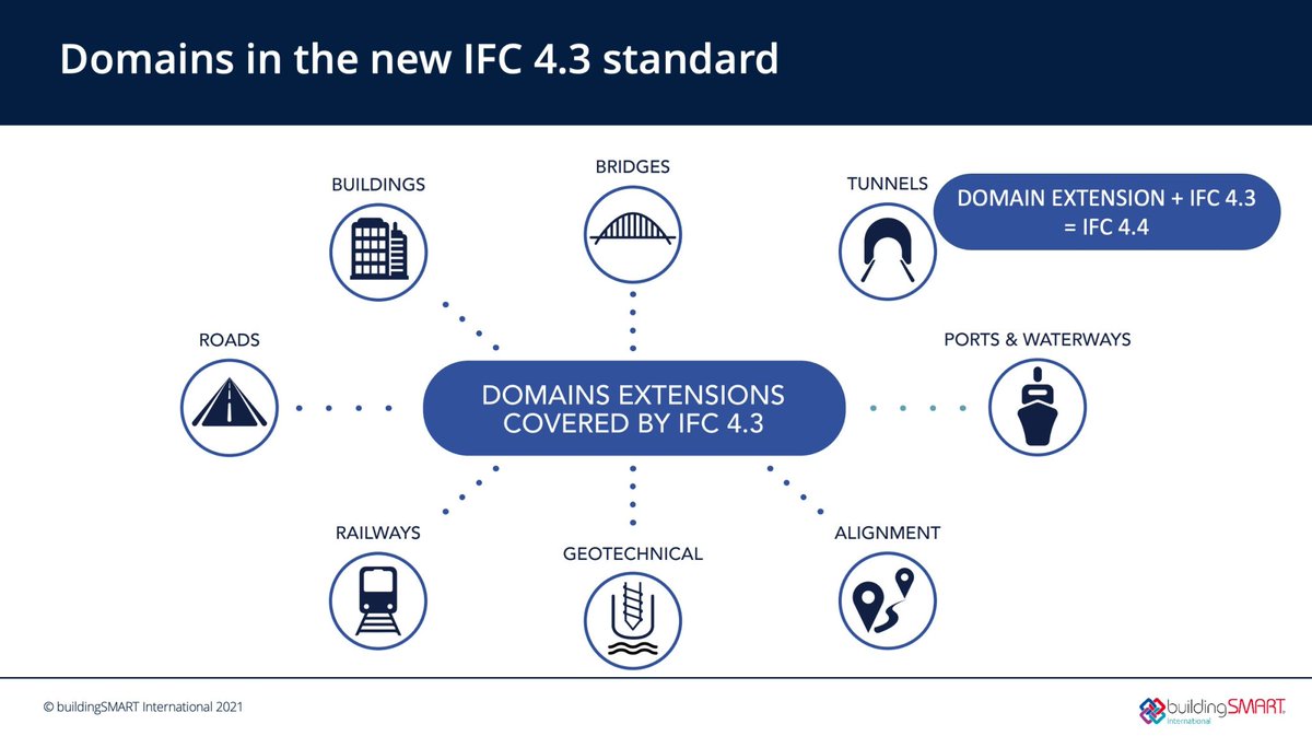
After a robust development process, bSI has published IFC 4.3 as a bSI Production Standard. By the end of 2022, it will also be further extended to incorporate Tunnel entities, which will be published as IFC 4.4. More details are available in this blog: hubs.ly/Q01grWVp0
Cool seeing Amazon’s LiDAR collection running live on their delivery vehicles. It would be fun to see the coverage maps these result in.
Discover the advantages of a career in the skilled trades: ow.ly/aKyV50JKycw #DigSafe

Huge news! I'm psyched to play with this one, have been using the alpha releases of v3 and it's a lot of great improvements.

Hooray, STAC Browser v3.0.0-beta.1 has been released! 🥳 Code: github.com/radiantearth/s… Demo: radiantearth.github.io/stac-browser/ Any feedback is appreciated! A blog post with details will follow.
Open source + open standards => more FAIR geospatial information => impacts. Just in time for #FOSS4G and @opengeospatial member meeting :)
OGC and @OSGeo have signed a new Memorandum of Understanding, renewing our partnership in support of closer collaboration to advance Open Geospatial Standards and Open Source Geospatial Software bit.ly/3Q5rGSj


Mandatory voting. An idea whose time has come? An obligation of citizenship? Requiring parties to appeal to broader public rather than just a small base?

@cathmckenna @LaRaisonVaincra Mandatory voting has been in place in Australia since 1924/ works well. Parties must appeal to all voters, not just minority target segment. Works in many other countries and is supported by a majority of Canadians . Like paying taxes this should be an obligation of citizenship
@narainananya at @geobuiz in Monterey — The Evolving Role of Federal Geospatial Data Providers.


An excellent piece here recognizing the leadership, vision and hard work @gzeiss @gzeiss has brought to our sector. Geoff congrats on this accolade it is well deserved. Thank you as well for being a mentor and a friend to me and s…lnkd.in/gYz-b9HA lnkd.in/ghWAiGxZ
Official today! We are pleased to announce that GHGSat has officially joined @ESA_EO's Earthnet Third Party Mission (TPM) programme, providing satellite data from its high-resolution commercial satellites to researchers free of charge 🛰️ Press Release: lnkd.in/gqpEPicV

Three new satellites in orbit around the Earth providing a clear view for a better future 🛰 GHGSat constellation is essential to ensure optimal emissions monitoring coverage and accurate data for industrial and financial use. #Transporter5 #spacex


Easy to understand explanation about the earths orbit around the sun and the impact on natural climate change - So What Are the 3 Milankovitch Cycles? Visit - easygeography.co.uk #space #geography #geographyteacher #climatechange earthhow.com/milankovitch-c…
The Landsat 9 Handbook is available to the public! Dive deeper into the newest satellite in the USGS earth observation program. ow.ly/tAoH50IKHOa


🏆 We're thrilled to announce that Ecopia AI won the Technology Innovation award at this year's #GWF2022 (@geoworldmedia) in Amsterdam, the Netherlands - recognizing the global success and impact of our AI-based mapping technology. ecopiatech.com/news-post/ecop… #AI #DigitalTwins

#GWF2022 | @geoworldmedia announced & presented its annual Geospatial Leadership Awards at Geospatial World Forum. Find out the complete award list, here: geospatialworld.net/news/geospatia… @kpomfret @k_satyarthi @KateRaworth @nadinesa @synspective @ghgsat @opengeospatial @AusSpaceAgency
Congratulations OGC CEO, Nadine Alameh, for becoming the 2022 Geospatial World Geospatial Diversity Champion of the Year for her leadership role in championing diversity and inclusivity across geospatial industry. Thank you for everything you do to evolve #geospatial community!

Trends for United States
You might like