Search results for #mowx
2:23 PM: Storms are developing in eastern Nebraska. Expect this activity to move east, with storms developing further south later this afternoon and finallyi into northwestern Missouri around 6 PM. Stay alert, they could arrive as early as 4 PM. #mowx #kswx #KC


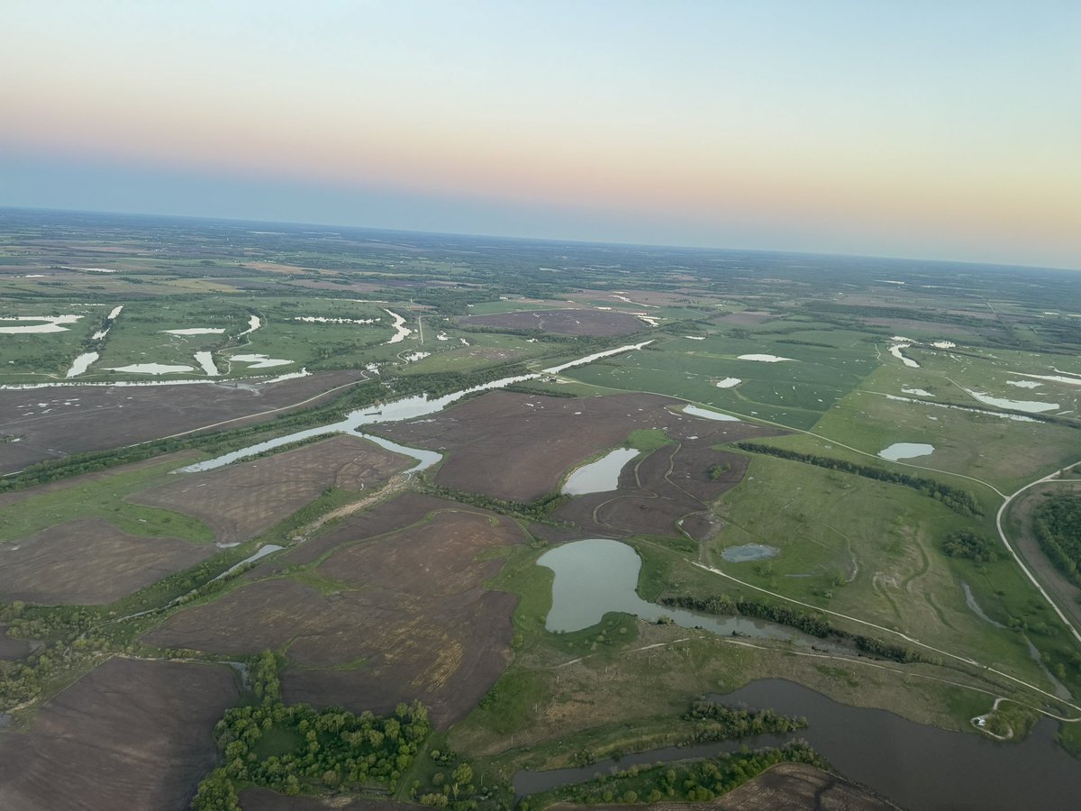
NWS Alert> Flood Watch in effect from 9 PM in Portions of east central Kansas, including the following area, Linn KS and west central Missouri, including the following area, Bates #mowx simpleweatheralert.com/cgi-bin/weathe…


😮Weather Watch AGAIN for Tues & Wed. More storms headed our way. Large hail + ⬆️winds expected. Prep tips: ready.gov, ready.iowa.gov, nema.nebraska.gov, sema.dps.mo.gov, ksready.gov #iawx, #kswx, #newx, #mowx, #kcwx,


#TornadoWatch coming for E #Nebraska, W #Iowa and NW #Missouri esp #Omaha,#LincolnNE,#BellevueNE,#CouncilBluffs,#DesMoines,#Ames,#Ankeny,#WestDesMoines,#Urbandale,#Johnston cities #Wxtwitter #Tornado #Hail #Wind #SPC #Severewx #Wxx #IAwx #NEwx #MOwx #TornadoAlley

#TornadoWatch coming for E #Nebraska, W #Iowa and NW #Missouri esp #Omaha,#LincolnNE,#BellevueNE,#CouncilBluffs,#DesMoines,#Ames,#Ankeny,#WestDesMoines,#Urbandale,#Johnston cities #Wxtwitter #Tornado #Hail #Wind #SPC #Severewx #Wxx #IAwx #NEwx #MOwx #TornadoAlley https://t.co/PiI2vVqZsE


1:07pm CDT #SPC_MD 0574 , #iawx #mowx #newx, spc.noaa.gov/products/md/md…


#Flood WATCH in effect til 5/01 9:00AM. For the latest radar, download our app on iTunes: ow.ly/xezc30gLiRz or Android: ow.ly/hTgt30gLiVt #MOwx #TurnAroundDontDrown
NWS Alert> Flood Watch in effect from 9 PM in Vernon County #mowx simpleweatheralert.com/cgi-bin/weathe…


We should get a good stage bounce up to 18' in a week.Upstream basins could get enough rain as we go along to keep stage here around 16' for 2 weeks. Best certainty I can project. "Behold the Lamb of God that takes away the sin of the world✝️🛐😇 #midsouthwx #tnwx #arwx #mowx

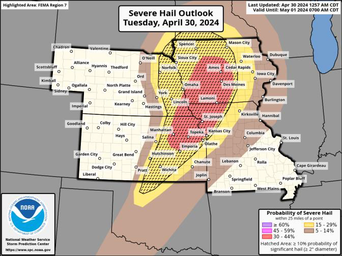
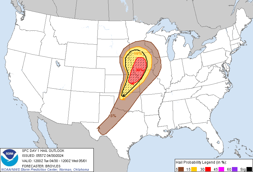
D1 #Enhancedrisk in N #TornadoAlley esp #DesMoines,#Ankeny,#WestDesMoines,#Urbandale,#Ames,#CouncilBluffs,#KansasCity,#IndependeceMO,#StJosephMO,#ManhattanKS,#Topeka,#LawrenceKS 5%#Tornado/30SIG #Wind/SIG #Hail risks #Wxtwitter #SPC #SevereWX #KCwx #KSwx #MOwx #IAwx #NEwx
D1 #Enhancedrisk in N #TornadoAlley esp #DesMoines,#Ankeny,#WestDesMoines,#Urbandale,#Ames,#CouncilBluffs,#KansasCity,#IndependeceMO,#StJosephMO,#ManhattanKS,#Topeka,#LawrenceKS 5%#Tornado/30SIG #Wind/SIG #Hail risks #Wxtwitter #SPC #SevereWX #KCwx #KSwx #MOwx #IAwx #NEwx https://t.co/Gndulf3mCn


This is why, when #tornado shelters exist, they need fail-safe backup access if doors remotely open. Ideally, someone should be available close by to open and is monitoring and ready when storms are nearby. #MOwx ozarksfirst.com/news/ozark-res…


#mowx Social @mowxSocial
136 Followers 50 Following User reported, user contributed. Send Missouri weather reports using #mowx! Follow @mowxSocial to keep up with current MO weather! Part of @SocialWeatherUS.
夜梦 @mowxP9U13X15981
6 Followers 9 Following


Nick Bender @NickBenderKMBC
20K Followers 2K Following Morning Meteorologist & Storm Chaser at @KMBC in Kansas City. I call the Plains Home. Christian. Husband. Father. Penn Stater. Angler. #MOwx #KSwx
T Eckhoff KB0UVT @Mowx1
67 Followers 191 Following coop weather observer Ham Electronics Weather Geology rock tumbling
Missouri Weather Watc.. @MOWX_Watch
32 Followers 42 Following Weather, photography, and nature enthusiasts.


Xuân Thy @ThyMowx
71 Followers 152 Following
1234 56 @MowxCbyxcEvWTxU
7 Followers 6 Following
mowx @mowx0201
8 Followers 105 Following

Mowx @kheldory199
76 Followers 361 Following

ابوبدر @MsHjGFrMOwx9IFl
4 Followers 5 Following


Myx_Mowx @Khoai_
76 Followers 147 Following

ちこ @hwUwnMOwxBivxg1
22 Followers 31 Following


桜月姫乄朧月 @w66Jb1VFuSqMOwx
24 Followers 43 Following

Matt Beckwith @KOMUMatt
5K Followers 4K Following Chief Meteorologist @KOMUNews|Mizzou Atmospheric Science Alum|@MizzouMet|Believer in Ethical Weather Communication|Opinions Are My Own |#MidMoWx|#MoWx|☀️🌦🌩🌈


Jessica Hafner @JessicaABC17
5K Followers 2K Following Chief Meteorologist at @ABC17News. @ametsoc CBM. Wife, mom 👶🏻🐶, runner🏃🏻♀️, and proud @NIUlive alum🐺. #CoMO #JCMO #LOTO #mowx #midmowx
هشام العراق.. @EukFQ4viooyMOWx
31 Followers 82 Following

あみぅっち(・`�.. @XuaMOWx8a270349
6 Followers 33 Following うらーかです。よろしくです。フォロしてくれた人だけね。キラカワ系です^_^ゲームの時に暴言吐く人に犯されたい。けっこうむちむちだけど抱けますか?


ÜMwxD(MoX)Ü @MowxD09
4 Followers 30 Following
Eason @8cmSP4ZL8mowxKW
3 Followers 8 Following

6477639360 @f3vMOWxENZ31iH6
4 Followers 9 Following
MOWX_94 @Dieu_EXO12_OSH
20 Followers 186 Following Em yêu thương một thiên thần, một thiên thần rơi từ trên trời xuống mà không bị đau mông - Oh Sehun 😑


tuan nguyen @mowx222
2 Followers 13 Following
CoMOStorm @CoMOwx
4 Followers 10 Following
Mad Mowx @MmeMowx
6 Followers 99 Following

のぶ @bxKkao3pmMOWx1F
2 Followers 5 Following
Khánh Đinh @MowxBorder
4 Followers 63 Following

.وسام الموس�.. @a4MOwxLZnq3GU0o
7 Followers 122 Following
. @Mowx140
0 Followers 0 Following
Nguyễn Thu Trang @TrangMowx
1 Followers 2 Following
oudsu @fPfNhuMOwx6HMhp
1 Followers 5 Following

Hải Mỡ @HaiMowx
0 Followers 12 Following
Rabbit @XxGizMowxX
7 Followers 0 Following
ام عبدالله �.. @MOWxQq7PftXK6IN
1 Followers 1 Following

ماجده ذكى @eGtqIrrX6pMowxO
4 Followers 17 Following
Tyu Xvg @tuyettnhii_mowx
0 Followers 3 Following
Елизавета Д.. @Gt7j4RaMOWx24f3
6 Followers 21 Following
りな @LS03eMOwxIVHZa4
0 Followers 110 Following
070 นายปิ�.. @1MOwxU5PQv27438
0 Followers 0 Following
まりまり @yPSl9oMOWxGn0gx
0 Followers 0 Following

jerome dela cruz @mowxD
1 Followers 20 Following
mowx @moxmjeekd
5 Followers 47 Following
新井周一 @MOWx81PoEM6Trd4
0 Followers 0 Following
جمان 33 @L0821MowxPIsWUQ
1 Followers 7 Following حياكم في حسابي لموقع حراج اتمنى من اي عميل يمر ع التغريدات يوصل للمعلن وين شاف الاعلان الله يسعدكم دعمكم لي شرف وشكراً للجميع
mr.mowx @al3tibi5112
3 Followers 3 Following
( ˙ ˙ ) @VFhp4vMOwx0N9hF
1 Followers 1 Following
An Mỡ @an_mowx
1 Followers 26 Following
شخصيه محترم.. @bj8lZoC6duMOWx7
1 Followers 12 Following
新田真剣佑 @TJGSe24MOwx5Ptk
12 Followers 157 Following
Mowx26 @mowx662006
1 Followers 16 Following


岡部雅由 @NjumjBtxw6MOwxM
0 Followers 1 Following
محمد سمبو @mMOwxHiNQqVIVRB
2 Followers 41 Following

Linh @nml_mowx
0 Followers 12 Following


أبداعات شبا.. @mowx9
2 Followers 38 Following
رائف @BwaByCHL6okMowx
0 Followers 0 Following


عبد فهد @L9MowxLh6BlegDJ
0 Followers 0 Following
MOWxVNSRS @MOWxVNSRS
0 Followers 0 Following
mosleha 123 alselamy @mowx12
1 Followers 54 Following
mowx @mowx12199990
0 Followers 11 Following
消极努力中 @AWwMOwxQ1u4EWz5
0 Followers 7 Following less talky talky,more fighty fighty,let’s destory them.