Search results for #miwx


948 PM 4/27 - Convective trends are being monitored for a potential Severe Thunderstorm Watch including parts of the Southern Lower Michigan region. #miwx
948 PM 4/27 - Convective trends are being monitored for a potential Severe Thunderstorm Watch including parts of the Southern Lower Michigan region. #miwx

8:42pm CDT #SPC_MD 0553 , #miwx, spc.noaa.gov/products/md/md…


Severe Thunderstorm Warning for Crawford, Montmorency, and Otsego County in MI until 10:15pm EDT. #miwx

Storm Factor Inc Severe Thunderstorm Warning for Crawford and Otsego County in MI until 10:15pm EDT. Be Weather Aware! #miwx
Severe Thunderstorm Warning for Grand Traverse and Kalkaska County in MI until 10:00pm EDT. #miwx
Storm Factor Inc Severe Thunderstorm Warning for Grand Traverse and Kalkaska County in MI until 10:00pm EDT. Be Weather Aware! #miwx

A line of storms extends from Manistee up towards Grayling, with a few severe thunderstorm warnings to our north tonight. #MIwx

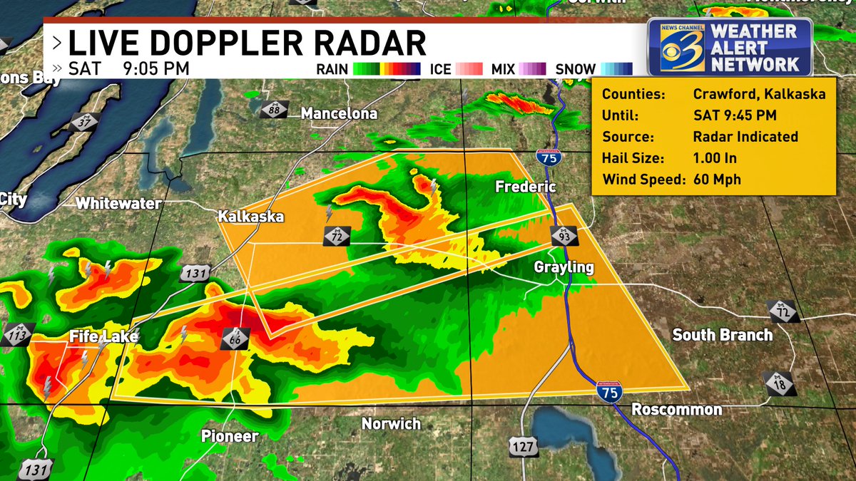

Saturday Evening Radar Update: As of 9:00 PM. Showers and thunderstorms are developing. A few severe t-storm warnings south of Traverse City. Storms are moving NE. Still stay weather aware going into tonight. #MIwx #severeweather @YourNewsNet @NewsNetNMI
Looking north into now severe warned storms. Severe thunderstorm warnings for Grand Traverse County, Kalkaska County, Crawford County. Storms moving north east quick with lots of lightning reports of hail from the storms.#miwx

Michigan friends: here is the 00z observation from Gaylord -- a quality thermodynamic and kinematic environment for the right storm. #MIwx

100+ MILES! That’s how far the anvil from this storm offshore of Ludington extends as of 8:30 PM EDT. It can be seen overhead Mount Pleasant, MI courtesy of MSC advisor @Joel_Fritsma. #miwx


823 PM 4/27 - Evening sounding data from our friends @NWSGaylord showing an environment conducive for severe weather this evening. Storms continue to intensify across Northern Lower and will continue as they begin to drop south this evening. #miwx


Oh baby she's cookin they might warn it #wxtwitter #miwx

As major severe weather still batters the plains and lower Midwest, storms are beginning to fire up right on schedule in our slight risk here in N. Lower Michigan! Strong Wind, Hail, frequent Lightning are the main threats right now #miwx


8:04 PM Radar depicts storms near Grand Traverse and Wexford counties. The main hazards with these storms are wind gusts up to 50 mph, frequent lightning, and penny sized hail #miwx
7:35 PM storms over south Cheboygan county are strengthening. Most likely hazards with these are wind gusts up to 40 mph, frequent lightning, and penny sized hail #miwx
7 PM EDT radar update: some storms popping up near Indian River this evening. More activity is expected over the tip of the mitt and NW lower over the next hour #miwx

miw miw💗. @miw_miwx
3K Followers 6 Following รับคอลเสียว คุยเสียว ขายรูป ขายคลิป โปรโมทเว็บ รีวิว🔥 ติดต่องาน 🆔miw.w7

Isaac Polanski @miwx97
2K Followers 937 Following CMU grad. Photography. Sony Cameras. Storm Chaser. Birds. Photographer for @TheChicagoDogs. Royal Oak DPS Water Dept. Stringer for @LiveStormsMedia.

MIWxAlerts_WASHTENAW @MIWxAlerts_WASH
49 Followers 1 Following Weather alerts, advisories, watches and warnings for Washtenaw County, MI
#miwx Social @miwxSocial
99 Followers 50 Following User reported, user contributed. Send Michigan Weather reports using #miwx! Follow @miwxSocial to keep up with current MI weather! Part of @SocialWeatherUS.
ぬ @miwx_v
20 Followers 8 Following
2丁拳銃 @MiwxVAuK65cRXqw
2K Followers 2K Following
MIWxAlerts_OAKLAND @MIWxAlerts_OAKL
35 Followers 1 Following Michigan weather alerts for the Oakland County Area
コウヤ @RDW4i0miwxVmnVi
367 Followers 40 Following ツイッターをやりたしてまだ新参者です 確実に会えたり仲良くしてくれる人募集です 悪質業者サクラは遠慮します 23の奈良で派遣の送迎してる浮気症の自己中心的で嘘ばっかりつかれて人を仇で返す彼女に捨てられました
MIWxAlerts_LIVINGSTO @MIWxAlerts_LIVI
32 Followers 1 Following Michigan weather alerts for the Livingston County Area
Miwwwwwwมันอ�.. @MiwxCTLS
11 Followers 13 Following I was born on Mars ~(M_CTLS)✈︎ สมัครมาแต่ไม่ค่อยทวีตอะไร เพราะเป็นสายชุ้ม
TDS Weather @TDSwx
5K Followers 21 Following Thermodynamic Solutions LLC | Professional Weather Consulting & Forensics | Lightning Alerts | Inquire [email protected] | #inwx #ilwx #ohwx #miwx #wiwx #agwx
Ricky Horror @rickyhorrorMIWx
110 Followers 48 Following Private Account. I play in a band called Motionless In White. Don't ask for a proof, I know who I am. Feel free to message/tweet me! :)

MIWxAlerts_BENZIE @MIWxAlerts_BENZ
6 Followers 1 Following Weather alerts, watches, warnings and advisories for Benzie County, MI
しゅん @MIWxQhWcfxsPEgl
221 Followers 70 Following from熊本 /福岡市/20代前半/社会人/171cm/64kg/経験値は低めですが普段の生活では出来ない出会いができたら嬉しいです!

James Miller @MIWxBrewer
12 Followers 16 Following
ًً @usMiwx
0 Followers 0 Following

𝐀𝐁𝐃𝐄𝐋 .. @miwx9_
4 Followers 3 Following

syndrome(سندروم @MiwxIaps
6 Followers 11 Following
issaw_amiw @miwx_nx
4 Followers 125 Following
Px @miwx8018
11 Followers 52 Following
潘思維 @c2gtrjMiwxQ2yzv
23 Followers 46 Following
M Interesting WxMan @MIWxMan
92 Followers 141 Following Known by many, seen by few. I am the most interesting weatherman in the world.
Bianca @BiancaMIWx
7 Followers 28 Following Siga minha fan page mores @universogatito 19y ♉ lufana 💛🖤
Matthew Scialdone @MIWxCreature
10 Followers 53 Following
♥•PIN70-) @MewMiwx69
4 Followers 5 Following
فاطمة بنت ع�.. @HuApEeqvHNbMIwx
105 Followers 636 Following ﴿ إِنَّ اللَّهَ عَلَى كُلِّ شَيْءٍ قَدِيرٌ ﴾


ريمو الجن @Q6tv0MiwxWaeZbI
14 Followers 69 Following

室賀明菜 @mMIwxZyDNS38651
0 Followers 2 Following
大橋宗桂 @yof7MIwxNmIk1v3
1 Followers 1 Following
David Young @WLNS_David
2K Followers 1K Following Emmy Award Winning @WLNS TV-6 Chief Meteorologist #Michigan #miwx #michiganweather #weather #WLNS #meteorologist #NCSU
JonBest @xMIWxFanx1088
4 Followers 15 Following
ほや @kvMIWx6cupMFJ6W
1 Followers 1 Following

no one @miwx_1
1 Followers 9 Following
𓆝 𓆟 𓆞 @mk_miwx
1 Followers 55 Following

رضا @nn1MiwxNkAEptS0
4 Followers 0 Following


木下こはる @6MIWxZIikCqRiPx
1 Followers 1 Following


乌托邦 @BzMiwxUln8jxcxK
9 Followers 99 Following

かな @R8KhmMiwx1w1pIW
4 Followers 3 Following アニメ&ガッキー大好き♥️/フォロバ100%/アニメ&ガッキー好きと繋がりたい(*'▽'*)♪/甘いもの好き😜/東京のイケメン男子と入れ替わりたい💕/気軽にフォローしてね😊


㊦ @ObM7kaXqPBhMIwx
0 Followers 45 Following
miwwy_m @miwx93
5 Followers 154 Following

محمد جهلان @dsLcjNfjMIwx7qC
5 Followers 69 Following

Miwx.✨ @MayAnn18654185
0 Followers 15 Following
perrie @LittleMiwx
1 Followers 9 Following ı'm perrie LOVE ONE DİRECTİON AND AVRİL LAVİGNE AND LİTTLE MİX
うらあか @S7HT7wpMIWxTrq2
0 Followers 11 Following

فاضل الساعد.. @QpQlaMIWxJzWc2e
5 Followers 0 Following إشتقتُ إليكَ.. فعلِّمني أن لا أشتاق علِّمني كيفَ أقُصُّ جذورَ هواكَ من الأعماق علِّمني كيف تموتُ الدمعةُ في الأحداق علِّمني كيفَ يموتُ القلبُ وتنتحرُ الأشواق
Panithan.miwx @Panitha45756612
0 Followers 16 Following 나는 Bangtan과 ARMY 모두를 사랑합니다 🥰❤️ 𝐉𝐮𝐧𝐠𝐤𝐨𝐨𝐤𝐢𝐞🥳💜 생일 축하합니다 정국
wata @WhT0qs0rMIwxLB5
2 Followers 26 Following


naoka57 @0WmIx7L6TN3MIwx
0 Followers 0 Following
ريفا @dMiwxF9jpV8cShM
1 Followers 0 Following

ryouhaaaaaan @rm313miwx
40 Followers 107 Following

Angel Alejandro @BMTH_MIWx
6 Followers 31 Following
Jennifer @N5CcMiwxKC86996
0 Followers 12 Following

Maneewan.. @19miwx
0 Followers 2 Following
曾守強 @KLV1yaDh7MIWxXS
1 Followers 0 Following
MiwxJoonie🥀💧 @JoonieMiwx
1 Followers 3 Following
Jennifer Ramirez @miwxZJeWhB6d
0 Followers 5 Following
twilight @xu7ZVBwrAiMiwxM
0 Followers 0 Following
عباس @fZhJsJmtQVtMIWX
0 Followers 18 Following
ابن هليمه @SkqMIwxMbqqTkN2
0 Followers 0 Following
Miwx @Miwx482372
0 Followers 62 Following

Ryan Elliott @MIWxINK
0 Followers 2 Following
Camila Mila @Miwx1k
0 Followers 1 Following
. @MIwx6hZ4OrdCTkx
0 Followers 0 Following
