Search results for #MasterMap

Calling all #architects, urban planners, and GIS enthusiasts! Test our latest sample and share your feedback. Our new Land Use layer of OS #MasterMap can save you time creating a Site Analysis and architectural reports. We'd love to hear your feedback! #SiteAnalysis #Feedback
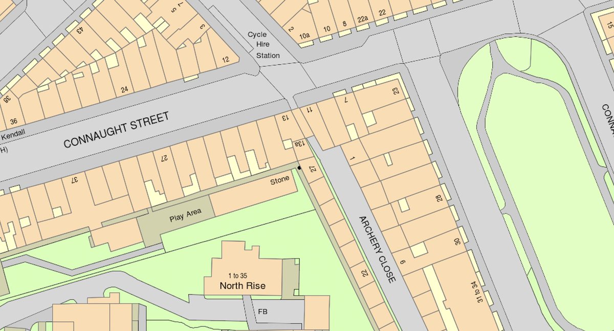
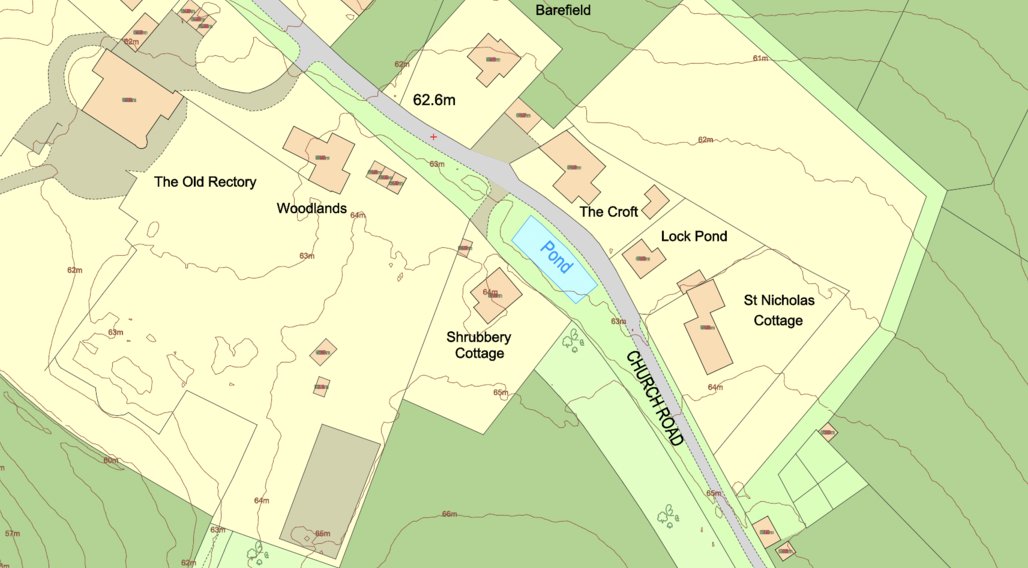
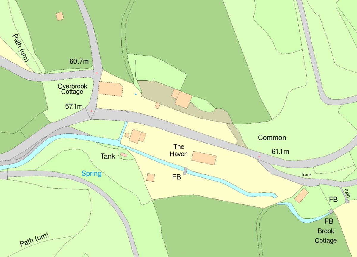
OS #MasterMap® is the most detailed and updated map of the UK and contains tons of information about the landscape of the UK. Did you know that it contains several key layers of information? They include topography, address, land use layers and much more. tinyurl.com/mway69w5
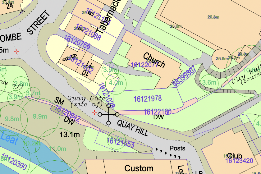
Today's tip: OS #MasterMap® is designed for display at 1:1250 scale, which means that one metre on the plan corresponds to 1,250 metres on the ground. You can read more about @OrdnanceSurvey's #map scales here: shorturl.at/irHI4 #mapping #scale #tipoftheday #os @theNBS

Curious about why you should use Ordnance Survey Mastermap? Here are a few compelling reasons to start using MasterMap. For more information, visit our website at centremapslive.co.uk/mapping #OSMM #Ordnancesurvey #Mastermap

Curious as to how using Ordnance Survey Mastermap can help you? Check out this case study from one of our recent clients. centremapslive.co.uk/case-studies #casestudies #OSMM #Mastermap #OS

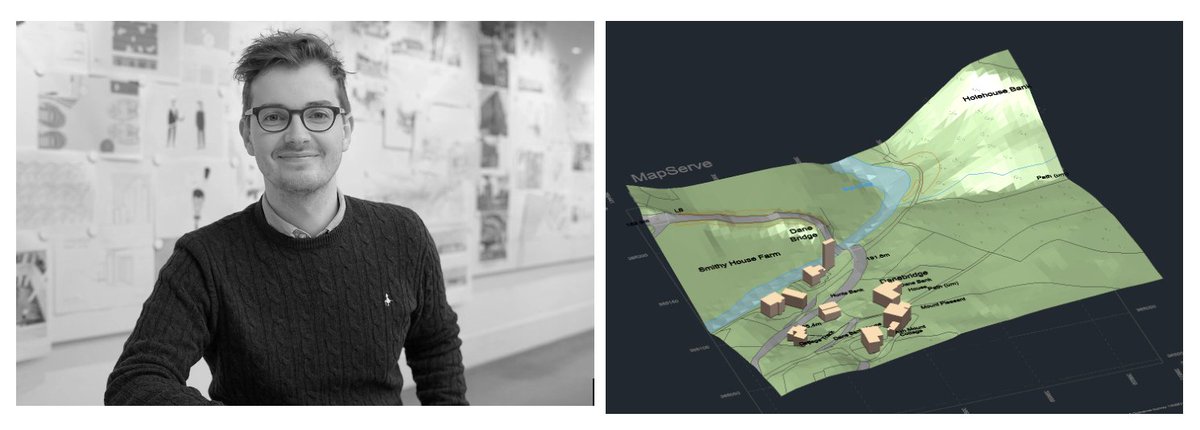
Ceri at Atelier Two #architectural studio saved over £1500 and 3 weeks of project time with MapServe's 3D #MasterMap®. Here's how: shorturl.at/djEK4 #mapping #architecture #3dmodel

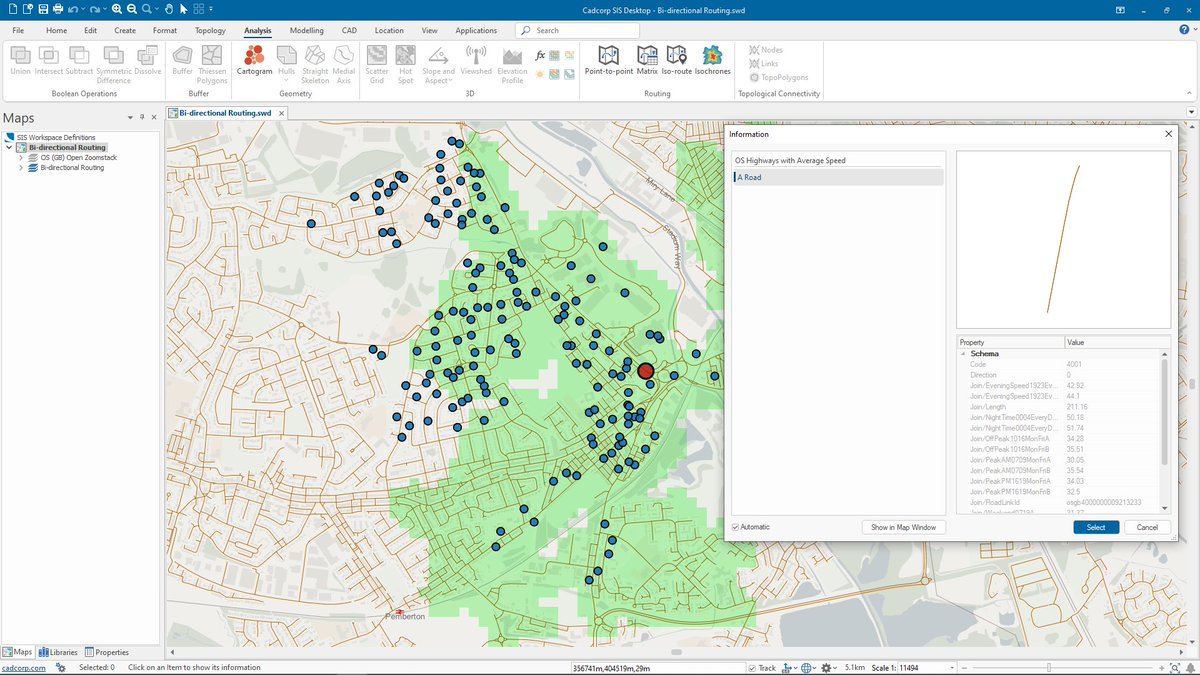
Cadcorp SIS 9.1 is here | #SISDesktop free route-finding tools now include bi-directional route costs and can be used with @OrdnanceSurvey #MasterMap Highways Network with speed data. What else is new? cdcp.io/sis9-1 #SIS9.1 #MakingSenseofPlace #spatialinsight #GIS
Discover the incredible advantages of our Ordnance Survey Mastermap! Here's a sneak peek of what you can expect. To explore these benefits and more, head over to our website now! centremapslive.co.uk/mapping #OrdnanceSurvey #MasterMap #GIS #Mapping #OSMM

OS #MasterMap®, the @OrdnanceSurvey's flagship product, is the most updated and detailed map of the #UK. Updates take place every 6 weeks. #maps #mapping #gis

Thought I'd try moving my @OrdnanceSurvey #Mastermap upload to @postgis processes to @SafeSoftware....but it doesn't like the feature collection format of the changehistory field. Surely there are #FME models for this somewhere? Any ideas #gischat? #gis #geo #geoautomation
Nick, director of Aubrey Architects, saved over £250 and significant drafting and modelling time using MapServe®'s 3D #MasterMap®. Here is how: shorturl.at/gMOT3 And download a sample here: shorturl.at/qEKT1 #mapping #architecture #maps @theNBS

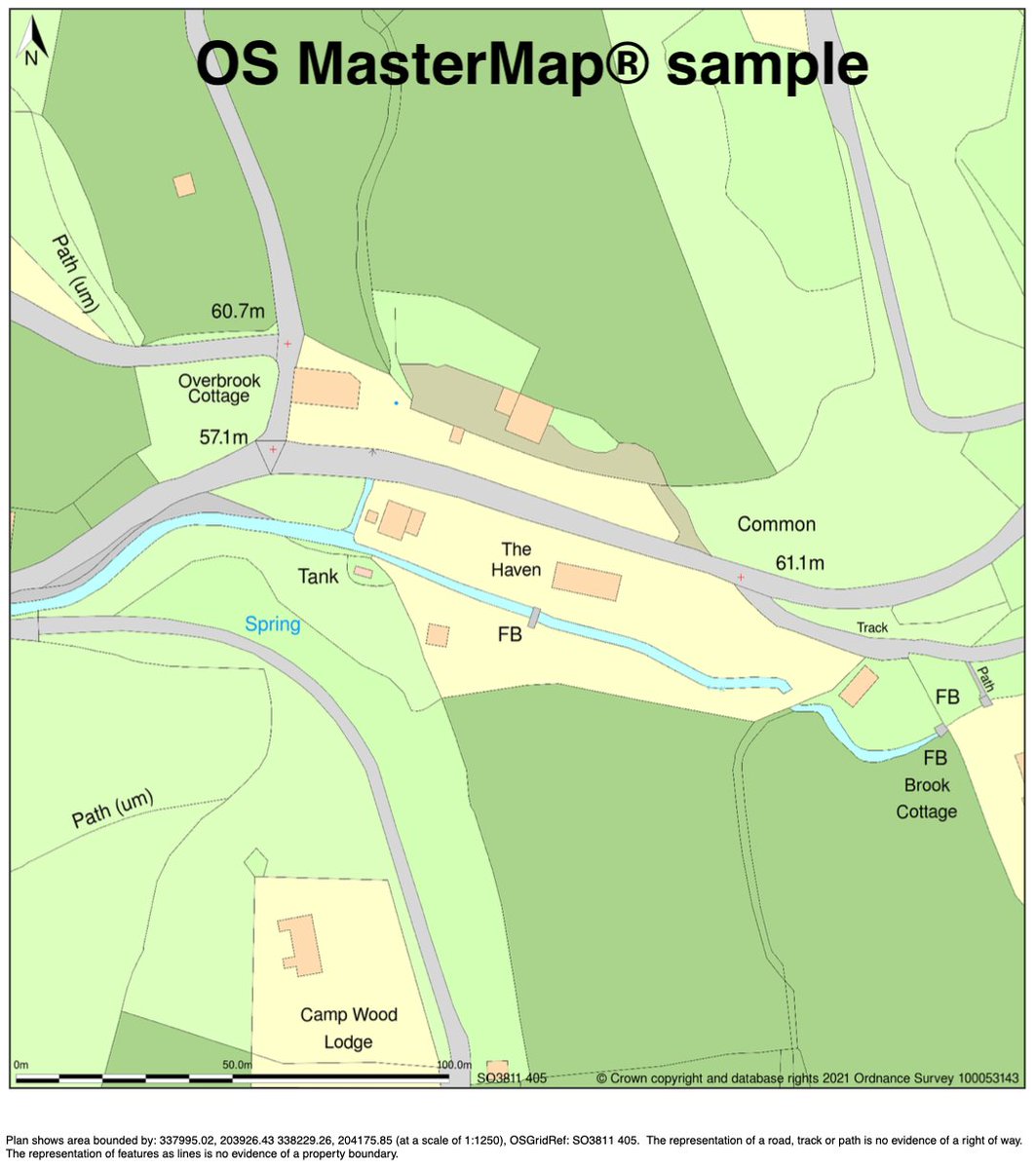
Did you know? OS #MasterMap® Topography Layer is generated and displayed at 1:1250, 1:2500, and 1:10 000 scales in urban, country, and mountain/moorland areas, respectively. Read more: shorturl.at/ciUYZ #mapping #ordnancesurvey @theNBS #architecture

We provide a vast range of digital mapping services. We work with a network of suppliers, including Ordnance Survey, to ensure we can offer a choice of content and formats: bit.ly/3QrSOLU #digitalmapping #mappingservices #ordnancesurvey #mastermap #addressdata

Ceri at Atelier Two #architectural studio saved over £1500 and 3 weeks of project time with Mapserve's 3D #MasterMap®. Here is how: shorturl.at/cmnoC @theNBS #mapping #architecture @mapserve
OS #MasterMap® is the #Ordnance Survey's flagship digital product that records every fixed feature greater than a few metres in the UK. Every day, a crew of #surveyors, pilots & analysts search & record changes of the land's topography. #mapping Read more:rb.gy/8gx6wr
The latest #OS #MasterMap® update is now live on #MapServe®! OS MasterMap® Topography layer gets updated every 6 weeks. #architecturenews #mapping #uk #theNBS @theNBS
Happy days, we've just launched 3D #MasterMap® on MapServe.co.uk for the #architects and other property professionals out there. Call 0330 133 3850 to learn more or get a sample (bit.ly/3UOm0yt). #mapping #maps

Quand le spatial est au service des trajets urbains buff.ly/3nYAbBT #MyEUSpace, #spatial #Mastermap #Nice06

Introducing NEW OS MasterMap Add Ons in our Layered PDF. Further enhance the richness of MasterMap data with additional layers of Aerial Imagery, Height Data and Tree Data. For more info and to test the Layered PDF see our blog: lnkd.in/eZ5cYD3K #MasterMap #Planning #Map


MasterMap @MasterMap
12 Followers 29 Following
MasterMap @_thexs_
5 Followers 31 Following
Blackwell's Mapping @Blackwells_Maps
833 Followers 486 Following We offer a fast and cost-effective digital mapping service, from planning application maps to OS MasterMap® & GIS data. Tweet us for free advice!
MasterMap @MasterMapMoney
0 Followers 0 Following We help simplify advice to grow your financial wellbeing. By The People, For the People.

MASTER MAP @mastermap_co
2 Followers 0 Following
MasterMap @MasterMap5
1 Followers 1 Following
mastermap2 @mastermap2
1 Followers 0 Following
MasterMap @MasterMap1
0 Followers 3 Following
mastermap1234 @mastermap1234
0 Followers 3 Following