Search results for #ILwx
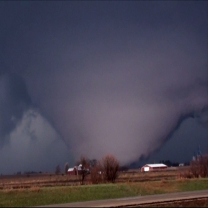
832pm: The squall line will continue to move east tonight with potentially damaging wind gusts and hail, low chance for a brief tornado. It should weaken as it moves east across northern Illinois tonight. We will update as the evening goes on. #ilwx


Lots of rain in some parts of Illinois this weekend. That could lead to #flashflooding in low-lying areas, near clogged storm drains, and areas near rivers and streams. Don’t drive into standing water. Turn around, don’t drown. #TADD #ILWx

Severe storms are about 125 miles to our west and moving about 40mph to the east which means they should move into the Joliet Area between 11:15-midnight. #ilwx


8:20pm: New Severe Thunderstorm Watch will be needed this evening across northern Illinois ahead of an advancing squall line. #ilwx

Timing for thunderstorm threat across north-central IL and Chicagoland. #ilwx


A watch will be needed for northern Illinois. I’m thinking a severe thunderstorm watch fits best #ilwx

Mesoscale Discussion has been issued for portions of northern Illinois including Joliet concerning the increasing threat for severe weather tonight. Probability of 80% for a severe thunderstorm watch to be issued soon. #ilwx


A Severe Thunderstorm Warning is now in effect. Get the latest from TV6 live on-air and online at kwqc.com/livestream/?ut… #iawx #ilwx #FirstAlertWeather #TV6
A Severe Thunderstorm Warning is now in effect. Get the latest from TV6 live on-air and online at kwqc.com/livestream/?ut… #iawx #ilwx #FirstAlertWeather #TV6
A Severe Thunderstorm Warning is now in effect. Get the latest from TV6 live on-air and online at kwqc.com/livestream/?ut… #iawx #ilwx #FirstAlertWeather #TV6
8:00pm CDT #SPC_MD 0551 , #ilwx, spc.noaa.gov/products/md/md…


A line of storms will move into areas near the Illinois River around 10-11 pm. Look for isolated severe storms within the line. #ilwx


Zolton Ilwx @ilwx
4 Followers 0 Following
たれ @L6XYRfJqxILWX8X
7K Followers 1K Following ゲーム好き30代。サターン派。サガとバイオハザードが特に好き。ロマサガリユニバースやってます。色々お気軽にど〜ぞ。YouTubeでプレイ記録動画の保存はじめました。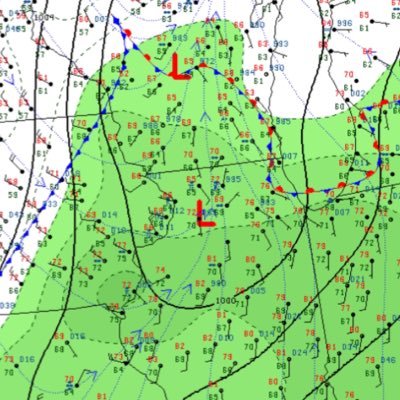
Ben Davison @NorthILWX
1K Followers 3K Following Multimedia Journalist And Co-Owner of TOW | Storm Chaser | Certified SKYWARN Spotter from NE IL. #forthelou
Central IL Weather @CentralILwx
179 Followers 17 Following Severe weather spotter and Springfield Weather Examiner
#ilwx Social @ilwxSocial
202 Followers 50 Following User reported, user contributed. Send Illinois Weather reports using #ilwx! Follow @ilwxSocial to keep up with current IL weather! Part of @SocialWeatherUS.

Brendan @brendan_ilwx
186 Followers 245 Following 20 | he/him | weather enthusiast | was on wxtwitter a long time ago | 🌪 count: 1
Luke🌪 || 🇬🇷�.. @luke_ilwx
390 Followers 791 Following ⛈chaser (🌪=6) || 93:7 || Eurovision, Weather & Politics || 🇵🇸 🇨🇩 ||Freeport Weather @Freeport_ILWX
154 Followers 89 Following Severe weather alerts for Freeport, IL, plus hourly condition reports. For more city weather alerts for Twitter users, click web link. Feeds provided by NWS.
West IL Weather @WestILWX
16 Followers 3 Following
Sean Ross @sean_ilwx
119 Followers 79 Following 19 ➡️ Storm chaser from Illinois ➡️ contributor and moderator for @tornado_talk ➡️ @TippieIowa
TDS Weather @TDSwx
5K Followers 21 Following Thermodynamic Solutions LLC | Professional Weather Consulting & Forensics | Lightning Alerts | Inquire [email protected] | #inwx #ilwx #ohwx #miwx #wiwx #agwx
超プルコギ @l39ILwx2kETEWF3
82 Followers 110 Following エクバ垢 いろんな人と繋がりたい 北九州でやってます! まだまだ弱いですがよろしくお願いします!ps4はモンハン、エイペックをやってます😊

Beth Carpenter | TDS .. @B_Carp01
7K Followers 123 Following Degreed Meteorologist | Co-Owner @TDSwx | Photography | Storm Chaser | GISer | Pickleball | @B_Carp01 on Instagram | #inwx #ilwx #ohwx #miwx #wiwx
IL Weather Authority @ILWxAuthority
107 Followers 89 Following A future Meteorologist/Storm Chaser that forecasts for the Central Illinois area. Follow for awesome weather updates and forecast maps around the region.
وعد @ilwx_5
22 Followers 24 Following


Chris Miller @CMiller_ILWx
139 Followers 233 Following Packers/Bucks/Brewers, UW-Milwaukee Alum, Retired meteorologist after 30+ years with the NWS. No tolerance for people that try to politicize science...
·Northern IL Weather @NorthernILWX
23 Followers 23 Following 🌦⛈Weather serving the Northern Illinois area ⛈🌦
Colby J South (Storm .. @Central_ILwx
33 Followers 164 Following Owner/Operator of Central Illinois Weather Live Media & Weather Digest https://t.co/N0UQcwOHmc

? @ilwx0_
5 Followers 91 Following
مجدوبي بوبك.. @cbILWxFHZhdbb3V
51 Followers 614 Following
ขนมหวาน.. @bquX8eSh3BpILWX
29 Followers 81 Following
Christie @Christie_ilwx
10 Followers 68 Following Storm chaser and photographer from the Midwest🌪, SKYWARN Spotter and Weather Enthusiast Co-Founder of https://t.co/RyWjPvLQsp
f 🐆 . @f2ilwx
4 Followers 1 Following
💙 @4ilwx1
1 Followers 4 Following
日東駒専ポーカ.. @5zRsGI6PXVsILWx
567 Followers 769 Following

🐱 @ilwx70
19 Followers 15 Following


.. @2ilwx
8 Followers 20 Following
Max Tsaparis @MaxTsaparis
4K Followers 1K Following Certified Broadcast Meteorologist & Producer @NewsNation in sweet home Chicago, formerly @wkow, AP award winner, FSU alum, he/him 🏳️🌈 #ilwx #wiwx #uswx
𖤐🌈⃤ @8ilwx90
4 Followers 20 Following
Brad Ott ILWX 🌪3 �.. @bradley_ott
549 Followers 3K Following 🏴☠️ Pirate’s Life $FLAG @forlootandglory
A🤍🌸 @2ilwx_
6 Followers 41 Following
M. @7ilwx1
11 Followers 26 Following

ピロ @CmzznIlwx3cbpoT
1 Followers 6 Following
الفحل الاسم.. @EWPUDaXS425ILWX
69 Followers 2K Following
顾清源 @yCOZjILwx9MKCw5
5 Followers 10 Following
🟠リウカ🌸🐎 @W9NMP9ilwx0MDTG
30 Followers 224 Following
x_xwli @ilwx_x
0 Followers 9 Following


...انا باكست�.. @vqIlwx7L6Qqljpb
14 Followers 108 Following


好人 @cheung_ilwx
0 Followers 1 Following
Manteno, Illinois Wea.. @MantenoILWX
10 Followers 40 Following Your local stop for weather information in Manteno, Illinois. Weather pictures, reports, forecasts, updates, and more. Run by @jakehockey50
درع @jiFVCDQLLPhILwx
0 Followers 0 Following
DJ @MendotaILWX
9 Followers 84 Following
ゆな @GwHkI82uBDgIlwx
4 Followers 17 Following
مؤمن عبدالت.. @0ilwxYmpKrUprgd
11 Followers 44 Following
بلد السلاطي.. @ILWxQgMoFXxgawq
1 Followers 2 Following


خالد صقر @Bw511KHuXE7ILWx
13 Followers 243 Following
まこ @6jM6IlwxDL9xZjr
96 Followers 485 Following

RAGHAD @ilwx77
7 Followers 0 Following
A. @ilwx_il1
1 Followers 62 Following

朱音 タロ社の�.. @ZXiZa6DpILWxCQy
8 Followers 46 Following フォーエイト好きの09 タロ社から神対応貰いたい その為に日に日に頑張ろうって思う気持ちが強くなる

/ @DlIlwx
17 Followers 26 Following
_7ilwx @7ilwx3
1 Followers 2 Following

5ّ. @5ilwx
0 Followers 0 Following
Мереке 86 @ILwxHtgtPKIqa8y
2 Followers 10 Following


マスカット @ilwxAdEiIR3FyeP
2 Followers 1 Following
にちか @7KYKfxbgIlwx2TL
2 Followers 0 Following


けちゃ @ilwx9Dir4m34335
0 Followers 0 Following
つねちゃん。 @HKNnzQvILWx4Ueu
5 Followers 9 Following


K @8Q5Ilwx9hasAuEW
0 Followers 0 Following
松永和博 @sKKg6gIlwx26826
0 Followers 10 Following
cemre @_m3ilwx
0 Followers 32 Following
الباشا @767M7ILwx7GttQ0
0 Followers 8 Following

伊藤越 @ILWX6pqctCgnlXF
0 Followers 1 Following