-
Tweets1K
-
Followers826
-
Following66
-
Likes589
Adam Pałęcki is making impressive strides in his #internship with us @geodepartment! He's diving deep into assessing Velodyne scanner accuracy, comparing real and simulated observations. Here's what he's up to:
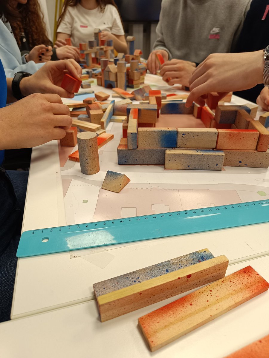
Support your daughter's interest in technology! Together with our colleagues from Higher Geodesy, we were glad we could host one of the @WienerToechter workshops at @tu_wien to give young girls some insights in our job as geodesists 🦸♀️👩💻👩🏭

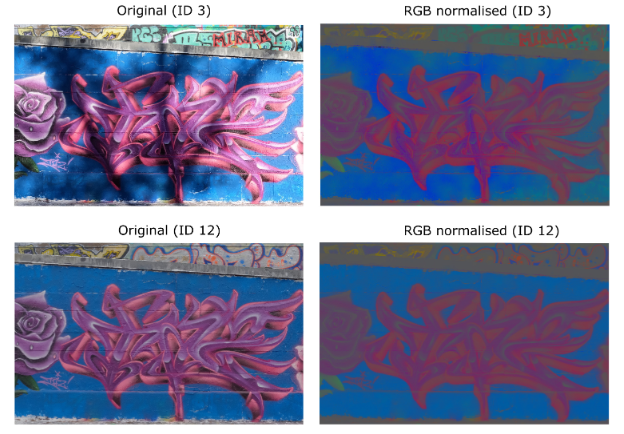
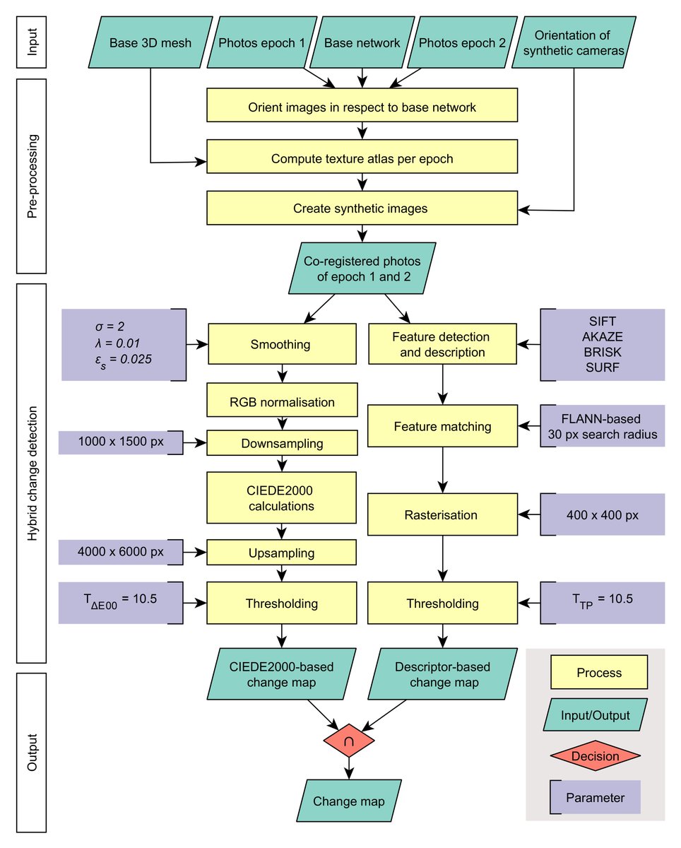
📢🚨Excited to share our latest @WileyGlobal paper on #graffiti documentation! 📷Explore our novel #GoPro-based #change detection method for #CulturalHeritage 👇👀 doi.org/10.1111/phor.1… @9bewild6 @NorbertPfeifer @GJJVerhoeven @geodepartment @URC_UGent
Was hat der Forschungsbereich Geodäsie mit Google-Maps und unserem Alltag zu tun? TUW-Geodät Johannes Böhm erklärt es im Interview. brnw.ch/21wHTFQ
🧭 Navigieren in schwierigem Gelände und das „Zwei-Körper-Problem", das Wissenschaftler_innen haben, wenn sie eine Familie gründen (wollen): Beides beschäftigt die Geodätin Jelena Gabela Majic, Postdoc an der TUW. 👉 "Woman in Science"-Interview: tuwien.at/tu-wien/aktuel…
The @CopernicusECMWF European State-of-the-Climate report is out! Again a great soil moisture section by @CLIMERS_GEO @planet @eodc and @ECMWF : climate.copernicus.eu/esotc/2023/soi… Spot the differences between #reanalysis and #satellite data:
🚁✨ We successfully used our new #DJI M350 RTK #drone with a 45 MPIX #Zenmuse P1 RGB camera for the first time! 📸 We captured the Rochus Chapel (Mannersdorf/Lower Austria) with nadir and oblique aerial images and created this animation from them! #EarthDay2024
On Monday: Master defense of Henri Schauer: Inundation–Desiccation State Prediction for Salt Pans in the Western Pannonian Basin using Remote Sensing, Groundwater, and Meteorological Data tuwien.at/en/mg/geo/even… @CLIMERS_GEO
#EGU2024 day 3 is starting🗣️ 9⃣ contributions from our side done✅ 5⃣ more to come📢 Check them out on tuwien.at/mg/geo/climers…
Irene receiving the @EuroGeosciences OSSP award of the hydrological division! @ismn_earth @ESA_EO #frm4sm @climers


Super inspiring #EGU24 presentation by Wolfgang Wagner @geodepartment on the start of soil moisture remote sensing "the purpose of the instrument (ERS scatterometer) was wind mapping over oceans, we were lucky it was switched on over land at all to avoid the instrument cooling"

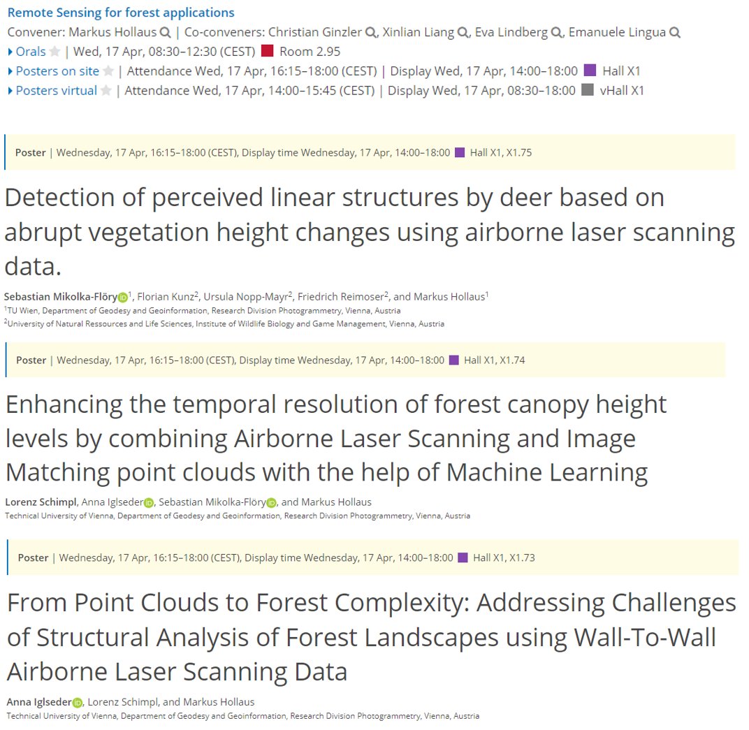
#EGU24 kicked off in #Vienna - a homerun for our group, as always. This year, we're prominently featured in session BG9.2, focusing on RS for forest applications. Drop by and say hi Wednesday! 👋👇meetingorganizer.copernicus.org/EGU24/session/…
On Monday: Master defense of Alina Reichert: Drought Monitoring and Tracking by Means of Remote Sensing - An Evaluation of Soilwater-based Drought Indices tuwien.at/en/mg/geo/even…
The EuroCarto 2024 abstract submission deadline has been extended to April 24th. We look forward to your submissions and to welcoming you to Vienna! #EuroCarto2024
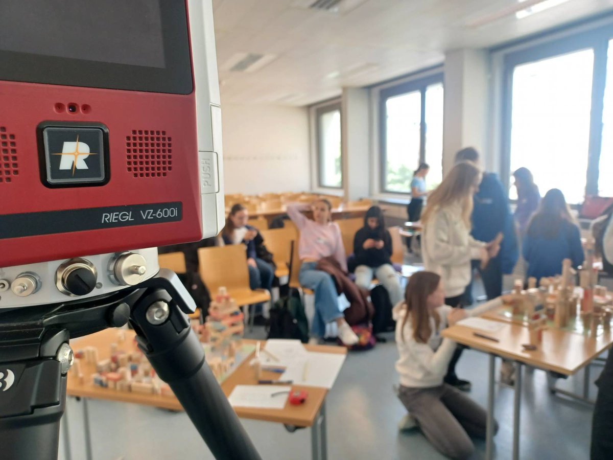
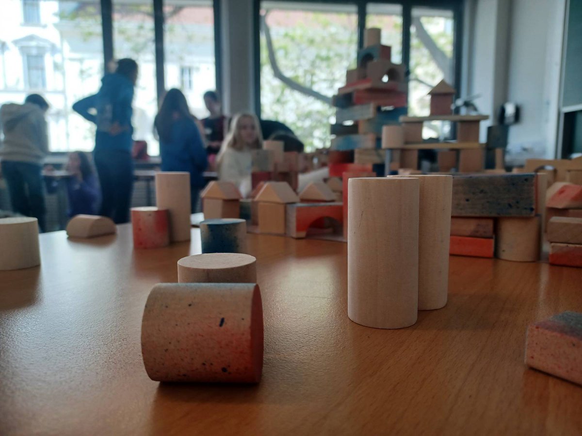
W H A T A S U C C E S S! 💫 Today at our annual Geo-Day @geodepartment we let young and older kids dive into the wonderful word of geodesy 😍
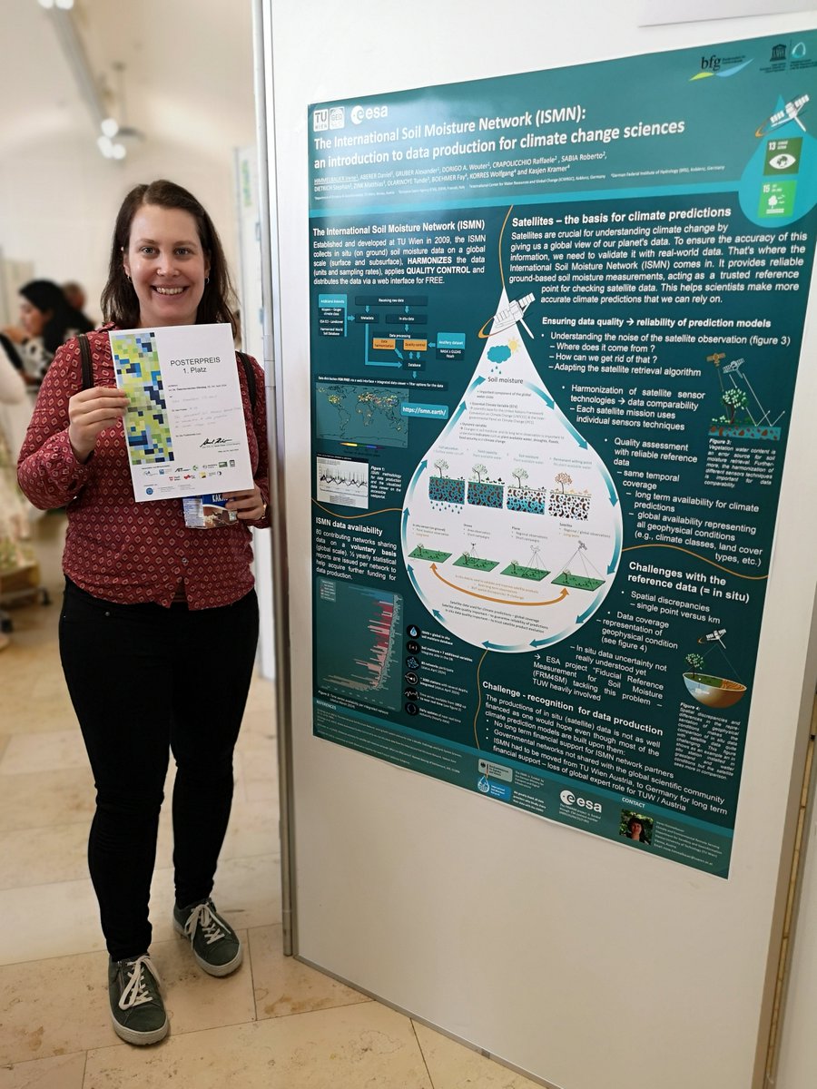
I'm very proud to announce that Irene and the @CLIMERS_GEO @ismn_earth team won the poster award at the @_CCCA_ Austrian climate conference! @ESA_EO
Gottfried Mandlburger is our new Professor of Optical Bathymetry @photo_TUW Welcome! tuwien.at/en/mg/geo/news…
🌳 We had a great time at Laxenburg Schlosspark together with our partners @IIASAVienna! We teamed up to measure forest plots with tape measure and TLS and even got to test our new mobile laser scanning processing scheme. We couldn't resist walking by the famous castle.
📣 New paper by @CLIMERS_GEO and @KU_Leuven on the #assimilation of #satellite #VegetationOpticalDepth #LAI and #SoilMoisture into a land surface model with dynamic vegetation. doi.org/10.1016/j.srs.…
🏔️🧊 🫠 Mountains without ice What is happening to our landscape? Read about SEHAG project's presentation in Prad (🇮🇹), where experts from @EURAC, @TU_Muenchen, @unieichstaett, and @photo_TUW shared insights into their research. 👇 dervinschger.it/de/thema/ein-r…
Photogrammetry @ TU W.. @photo_TUW
562 Followers 446 Following Photogrammetry research unit @geodepartment at @tu_wien. Research on various fields of photogrammetry & developing OPALS software.
Hydrology IRPI-CNR @Hydrology_IRPI
12K Followers 2K Following We exploit satellite🛰️and ground📡 observations for #hydrology☔#flood🏞️#drought🏜️#landslide⛰️#irrigation🌱#precipitation🌧️#streamflow🌊+climate change
Wouter Dorigo @wouterdorigo
578 Followers 289 Following Using Earth observation to understand natural and human impacts on the climate and ecosystems of our planet, and to unravel climate feedbacks
Bernhard Höfle @BernhardHofle
787 Followers 639 Following University Professor of #Geography 🌍 #Geoinformatics. Private account. ➡️Check @3DGeoHD for our science twitter. https://t.co/4DobJCGyQJ
Johannes Scholz @Joe_GISc
1K Followers 1K Following Univ Prof for Geoinformatics, @Z_GIS1 at @PLUS_1622. Marathon-addict; @[email protected]
Jacopo Dari @jacopo_dari
816 Followers 1K Following
TU Wien @tu_wien
11K Followers 221 Following Mit rund 26.000 Studierenden ist die TU Wien Österreichs führende Bildungsinstitution auf den Gebieten Naturwissenschaft und Technik.
cartography @TU Wien @cartogroup
646 Followers 459 Following Research Unit Cartography at Vienna University of Technology and host of https://t.co/tjKhhVdNgD
CLIMERS @CLIMERS_GEO
220 Followers 44 Following Climate and Environmental Remote Sensing @geodepartment @tuvienna
Martin Mokros 🌳 �.. @m_mokros
1K Followers 612 Following Generating 3D point clouds of a forest since 2012 🌳📷 Lecturer in Earth Observation at University College London; Chair of @3DForEcoTech COST Action
Florian Ledermann @fl.. @floledermann
878 Followers 439 Following ᴍᴏᴠᴇᴅ ʜᴇʀᴇ → https://t.co/moBQSp3blU
David Montero Loaiza @dmlmont
3K Followers 1K Following Creator of #AwesomeSpectralIndices | #eemont | #spectral PhD Student @RSC4Earth. 🇩🇪 @UniLeipzig ← 🇪🇦 @unican ← 🇨🇴 @UnivalleCol. 🌎 #EarthEngine GDE.
3DGeo Research Group .. @3DGeoHD
634 Followers 118 Following 3DGeo Research Group ∙ @UniHeidelberg ∙ Germany Research: #Computational methods for the #geographic analysis of 3D/4D #PointClouds Head: Prof. @BernhardHofle
Clement Albergel @CAlbergel
1K Followers 880 Following @ESA Climate Applications Scientist @esaclimate, Land Surface Modelling & Remote Sensing 🌎🛰💧🌱🔥|🇪🇺🇫🇷🇬🇧 Scientist from @CNRS
Annette Eicker @annette_eicker
644 Followers 412 Following Professor at HafenCity University Hamburg, using #geodesy to study system Earth. President @EGU_Geodesy, #satellites #climate, views my own
GGOS - Global Geodeti.. @IAG_GGOS
1K Followers 129 Following GGOS is the Observing System of the IAG (@iag_geodesy). GGOS works with the IAG to provide the geodetic infrastructure necessary for monitoring the Earth!
Lothar Schüller @LotharSchueller
907 Followers 465 Following SAF Network Manager @EUMETSAT. Responsible for the Satellite Application Facilities that provide operational data and software services. All views are my own.
International Soil Mo.. @ismn_earth
204 Followers 34 Following The International Soil Moisture Network is an international cooperation to establish and maintain a global in-situ soil moisture database.
Copernicus EMS @CopernicusEMS
68K Followers 2K Following Copernicus Emergency Management Service provides mapping products based on satellite imagery as well as #ForestFires #Flood and #Drought early warning products.
michael GOULD (@mgoul.. @0mgould
11K Followers 3K Following GIS professor and Global Education Manager at Esri (opinions my own). #travel #mountainbike #internationalDev #GIS #Spain #sarcasm
ISPRS 2026 Toronto @ISPRS2026TO
32 Followers 27 Following Official account of the ISPRS2026 Congress. XXV ISPRS Congress is returning to Canada in 2026! Stay tuned for updates and join the discussion #ISPRS2026
Jaime Gaona @JaimeGaona1
408 Followers 2K Following Postdoc at @Hydrology_IRPI #hydrology #drought #remotesensing #soilmoisture#plant-water interactions
Mina Karimi @MinaKarimi_sma
60 Followers 146 Following University Assistant Postdoc @univienna, Spatial Data Science, Geographic Information Science
Aditya Singh @aditya2geo
5 Followers 57 Following 🌐 GIS Engineer | Remote Sensing Specialist 🛰️ | GEE | Machine Learning | Image Processing | Hobbyist Photographer (Fujifilm) 📸
Yihui Wang @gary_yihui_wang
638 Followers 4K Following PhD in Water Resources Engineering and Science at @HydroLab_UIUC @UofIllinois. MSc at @NUSingapore. #Vegetation #Turbulence #WindWaves #Particles #Experiments.
Alfredo LF @ajlf88
443 Followers 5K Following Caribeño Colombiano; Me gusta Hablar y Escuchar; Orgulloso Hijo de la Universidad Pública; No hay Preguntas estúpidas; Amante de la Naturaleza; Ser Curioso...
lennartfynn @randomlfk
4 Followers 81 Following
herisutanta @heri_sutanta
13 Followers 271 Following
ABHISHEK RAI @abhishekrai921
58 Followers 509 Following PhD Research Scholar at IIT Roorkee An Architect and Geomatics Engineer Research interest in Mobile mapping, Augmented Reality, Photogrammetry and Deep Learning
Dr. Berkant Konakoğl.. @berkantkonak61
199 Followers 566 Following Harita Yüksek Mühendisi | Doç. Dr. | Amasya Ü. | KTÜ’lü | Trabzon'lu
Foteini Dervisi @_fderv
310 Followers 2K Following Marie Skłodowska-Curie ESR @BritGeoSurvey @spin_itn PhD student @EdinburghUni Currently visiting @UniPadova Machine learning based earthquake forecasting
Yi Yu @yy_nash13
78 Followers 245 Following PhD Student at @ANUFennerSchool and @CSIRO | Earth observation 🌏 | Remote sensing 🛰️ | Ecohydrology | Geostatistics
Hüseyin Topan @htopan
428 Followers 461 Following 🌍 Geomatics 🛩️ Photogrammetry 🛰️ Remote Sensing Prof&Head @beungeomatics, Founder @GeoEtrim, Co-chair @EARSeL_tweet SIG Urban Remote Sensing, RT≠endorsement

Dong Ning @biodning
269 Followers 346 Following Postdoc at Imperial College London, interested in plant traits, nitrogen, soils and fire!
Ayush Dabra @ayush_dabra
4 Followers 313 Following

Odun ayo, Ph.D @dave_adeniyi
520 Followers 377 Following EO Africa fellow @esa | digital soil mapping | Agric and Environmental Engineer | soil moisture | machine learning | geospatial analysis| Not I but Christ
Hongliang Ma @HongliangMa5
81 Followers 385 Following PostDoc in INRAE, France now and Phd from WHU. VOD , soil moisture from microwave (L-MEB), and VCW from optical remote sensing (PROSAIL), respectively
Theeraruk Maneenart @Theeraruk
34 Followers 643 Following
Lukas Stampfer @lukas_muasch
33 Followers 173 Following sollt eigentlich was Anderes machen, bin aber trotzdem hier
baugeschichte @FoBaugeschichte
0 Followers 3 Following
murat koyun @dramorey
12 Followers 615 Following
Siti Hajar Aswad @ogut_poenya
575 Followers 846 Following ENFP-A |Muslim |Try to be the best of me |TN XIX | @geodesi2011 | https://t.co/aCnZDA9dhB

Nazaninpd @Nazaninpd1
17 Followers 71 Following
Alireza Hamoudzadeh @SpatialAli
8 Followers 67 Following Ph.D. candidate @SapienzaRoma, Geodesy and Geomatics Division, #GEDI and #SWOT for water and glacial level monitoring, and Google Earth Engine.
Andreas Hanzl @andihanzl
28 Followers 224 Following PhD student @ Earth Observation for Ecosystem Management, TU Munich | Working on the interchange of LiDAR and microclimate | Geographer 🗺️
Ibaad Anwar @Ibaadanwar
6 Followers 139 Following
Sam @sammyhawkrad
16K Followers 9K Following Cartographer 🗺 | Data Scientist 📊 | Web Developer 👨💻 | OpenStreetMap Contributor🌍 | Erasmus Scholar @cartography_msc
Nancy @nancy_liesmann
144 Followers 3K Following
Dariela Vazquez @darantav
58 Followers 241 Following Civil Engineer, MSC in Environmental Engineering focused on water resources and remote sensing. 'I'm diamond, you know I glow up'
SMZ Natural & Pure Co.. @smznatural
12 Followers 174 Following
H_H @twharald
21 Followers 16 Following
Harold Prosper @HaroldUlotu
3 Followers 41 Following
Arko Lucieer @TerraLuma
1K Followers 933 Following Head of School of Geography, Planning, and Spatial Sciences and Professor in Remote Sensing at the University of Tasmania. Founder of TerraLuma research group.

Mert Turunç @GeoTurunc
30 Followers 149 Following Geomatics 🗺️ Jack of all trades, master of none 🃏 Doing things @

Vassilis Sitokonstant.. @vassilis_sito
209 Followers 524 Following Causal ML for sustainable agriculture and food security @isp_uv_es; @imperialcollege + @ucl + @ntua alumnus
Sukrikur @Sukrikur
0 Followers 72 Following
asdfghjkl @niyeymiski
1 Followers 589 Following
Abdulkadir Memduhoglu @kadirmemduhoglu
214 Followers 734 Following Assist. Prof of Geomatic Eng @hrumedya. PhD in Remote Sensing & GIS @YildizEdu. PostDoc @GIScienceHD. Specializing in GeoData Integration, GeoSemantic Web, VGI.
Volkan Yılmaz @volkanylmz61
1K Followers 5K Following Associate Professor of #RemoteSensing @tcktu1955 | Associate Editor of @IJRemoteSensing | Member of @isprs |
Mehdi Boroumand @MehdiBoroumand2
8 Followers 48 Following Geospatial & Mapping Specialist , passionate for 3D modelling of built environment and innovative mapping solutions
Luca Morelli @lcmorelli3
42 Followers 85 Following
Photogrammetry @ TU W.. @photo_TUW
562 Followers 446 Following Photogrammetry research unit @geodepartment at @tu_wien. Research on various fields of photogrammetry & developing OPALS software.
Copernicus EU @CopernicusEU
134K Followers 2K Following The Earth Observation component of the EU Space Programme
Hydrology IRPI-CNR @Hydrology_IRPI
12K Followers 2K Following We exploit satellite🛰️and ground📡 observations for #hydrology☔#flood🏞️#drought🏜️#landslide⛰️#irrigation🌱#precipitation🌧️#streamflow🌊+climate change
Wouter Dorigo @wouterdorigo
578 Followers 289 Following Using Earth observation to understand natural and human impacts on the climate and ecosystems of our planet, and to unravel climate feedbacks
ESA Earth Observation @ESA_EO
143K Followers 3K Following @esa #EarthObservation: Taking the pulse of our planet from space. Please see our Privacy Notice: https://t.co/zzMYcxj8xi
TU Wien @tu_wien
11K Followers 221 Following Mit rund 26.000 Studierenden ist die TU Wien Österreichs führende Bildungsinstitution auf den Gebieten Naturwissenschaft und Technik.
cartography @TU Wien @cartogroup
646 Followers 459 Following Research Unit Cartography at Vienna University of Technology and host of https://t.co/tjKhhVdNgD
CLIMERS @CLIMERS_GEO
220 Followers 44 Following Climate and Environmental Remote Sensing @geodepartment @tuvienna
Cartography M.Sc. @cartography_MSc
723 Followers 31 Following Cartography is an International Master of Science Programme of four universities focussing on a broad education in cartography and geoinformatics.
International Soil Mo.. @ismn_earth
204 Followers 34 Following The International Soil Moisture Network is an international cooperation to establish and maintain a global in-situ soil moisture database.
Österr. Gesellschaft.. @OVG_Austria
41 Followers 39 Following
Fondazione Bruno Kess.. @FBK_research
10K Followers 10K Following 🇮🇹 🇪🇺 Research Institute on #AI #QuantumTech #EcologicalTransition #DigitalTransformation #DigitalAgriculture #DigitalHealth #DigitalIndustry #Cybersecurity
Wolfgang Wagner @wwagner42
16 Followers 12 Following
Gottfried Mandlburger @GMandlburger
49 Followers 1 Following
Norbert Pfeifer @Norbert_Pfeifer
101 Followers 40 Following research and teaching #photogrammetry @tu_wien @geodepartment @photo_TUW, #laserscanning
VRVis @VRVis
1K Followers 1K Following All about the research and people of VRVis - Zentrum für Virtual Reality und Visualisierung Forschungs-GmbH. Science Communication. Posts in English and German.
SynerGIS Informations.. @SynerGIS_Info
166 Followers 45 Following Als Esri Distributor für Österreich unterstützen wir Sie bei der GIS Integration in Ihre Unternehmens-IT. Wir bieten Beratung, ArcGIS Erweiterungen & Schulungen

AllTerra @AllTerra_NZ
38 Followers 21 Following AllTerra serves the New Zealand and English-speaking South Pacific Islands for #Trimble geospatial solutions.
RIEGL @RIEGL
6K Followers 2K Following RIEGL delivers Smart Waveform technology in unmanned, airborne, mobile and terrestrial laser scanning solutions. https://t.co/3h8i1Riyxx
Graffiti project INDI.. @projectINDIGOeu
153 Followers 303 Following #graffiti-centred academic project funded by Heritage Science Austria @oeaw
LBS2ITS @Lbs2I
15 Followers 21 Following Curricula Enrichment delivered through the Application of Location-based Services to Intelligent Transport Systems (LBS2ITS) / Erasmus+ project
Vienna Scientific Clu.. @VSCluster
416 Followers 123 Following • Most powerful supercomputer in Austria • Center of research and first-class HPC training • Learn parallel programming & more: https://t.co/CQDHxcFU9r
TUForMath @math_tu
34 Followers 32 Following Wir sind umgezogen: Aktuelle Tweets von TUForMath finden Sie ab sofort auf dem Kanal der TU Wien @tu_wien (https://t.co/74twBGcdoP)
CCCA - Österreichisc.. @_CCCA_
2K Followers 573 Following The CCCA is the main contact point for researchers, politicians, the media, and the public for all questions concerning climate research in Austria.
Remote Sensing MDPI @RemoteSens_MDPI
17K Followers 980 Following No. 1 #remotesensing #openaccess journal in Remote Sensing Category in #WoS, published by @MDPIOpenAccess; IF 2022 5.0; CiteScore 2021 7.9; #mdpiremotesensing
EO AFRICA R&D Facilit.. @EOAfricaRD1
910 Followers 115 Following EO AFRICA: Building an African-European R&D partnership to facilitate sustainable use of Earth Observations in Africa. Funded by @ESA, led by @facultyITC
C-SCALE @C_SCALE_EU
114 Followers 50 Following #Copernicus #EOSC Analytics Engine - The European Open Science Cloud as scalable computing infrastructure supporting Copernicus Services. #H2020
SilviLaser2021 @SilviLaser2021
179 Followers 14 Following SilviLaser 2021 is the 17th conference in a series focused on the applications of lidar and related technologies for assessing and managing forest ecosystems.
TU Green Team @TUGreenTeam
37 Followers 14 Following The TGT is a network of dedicated employees of the TU Vienna who are committed to implementing sustainable, climate-friendly and energy-efficient activities.
Horizon Europe🇪�.. @HorizonEU
181K Followers 2K Following Official DG Research & Innovation account for EU's #HorizonEU research & innovation programme Follow @EUScienceInnov & @lemaitre_eu
G3P @G3P_EU
281 Followers 318 Following G3P is an @EU_H2020 project. Satellite-based measurement of the global #groundwater distribution.
GATHERS @GATHERS_EU
122 Followers 75 Following #GATHERS – Integration of #Geodetic & imAging TecHniques for #monitoring and #modelling the Earth's surface defoRmations and #Seismic risk. GA No 857612
European Research Exe.. @REA_research
29K Followers 979 Following @EU_Commission 🇪🇺 Research Executive Agency funding #HorizonEU, #MSCA, #RFCS & #EUAgriPromo. Our Director is @tachelet 🔗 Privacy: https://t.co/J0tocgzxac
World Water Council @wwatercouncil
14K Followers 721 Following We bring together 350 member organizations from 50+ countries to make #water a global priority. We also co-organize the #wwaterforum. Together, To gather, Water

geodaetentag.at @geodaetentag
52 Followers 69 Following Hier twittert das Organisationsteam des Österreichischen Geodätentages 2018. #wirsehenmehr
GWP CEE @GWPCEE
2K Followers 2K Following Global Water Partnership CEE is working towards a water secure world in Central and Eastern Europe!
VOLTA @VOLTA_MSCA
156 Followers 85 Following VOLTA - Innovation in geospatial and 3D data. H2020 Marie Skłodowska-Curie RISE project, Grant Agreement No 734687
Geoinformation TU Vie.. @geoinfo_tuv
183 Followers 39 Following
AGEO.at @ageo_at
252 Followers 128 Following Der Österreichische Dachverband für Geographische Information - AGEO: die fachübergreifende Interessensvereinigung für Geoinformation und Geoinformatik.
Johannes Böhm @J_Boehm72
154 Followers 61 Following

I-REACT @IREACT_EU
4K Followers 2K Following Social media, smartphones and wearables to improve disaster management for floods, fires & extreme weather events. Funded by @EU_H2020 under GA 700256.

FIG Young Surveyors @fig_young
3K Followers 286 Following YSN - Network under the umbrella of FIG for survey, land and geospatial students and young professionals Chair: @_fpk_; Vice-Chair: @ChapunzaS
DGfK e.V. @dgfk_net
461 Followers 46 Following Magst du auch Karten? Die Deutsche Gesellschaft für Kartographie setzt seit 1950 für Kartenbegeisterte Maßstäbe.
DVW BadenWürttemberg @DVW_BW
56 Followers 0 Following
INTERGEO @InsideIntergeo
4K Followers 563 Following 24 - 26 September 2024 | STUTTGART | The World's No.1 Event for the Geospatial Community | Digital Twins, Digital Mapping, BIM, Smart City, UAV
GIM International @gim_intl
9K Followers 3K Following GIM International focuses on reporting the latest news and communicating new developments and applications in geospatial surveying.
NASA Earth @NASAEarth
3.7M Followers 99 Following NASA’s favorite (habitable) planet. 🌎💚 Studying Earth from ground to orbit. Verification: https://t.co/86cw0iJQEy
NASA Climate @NASAClimate
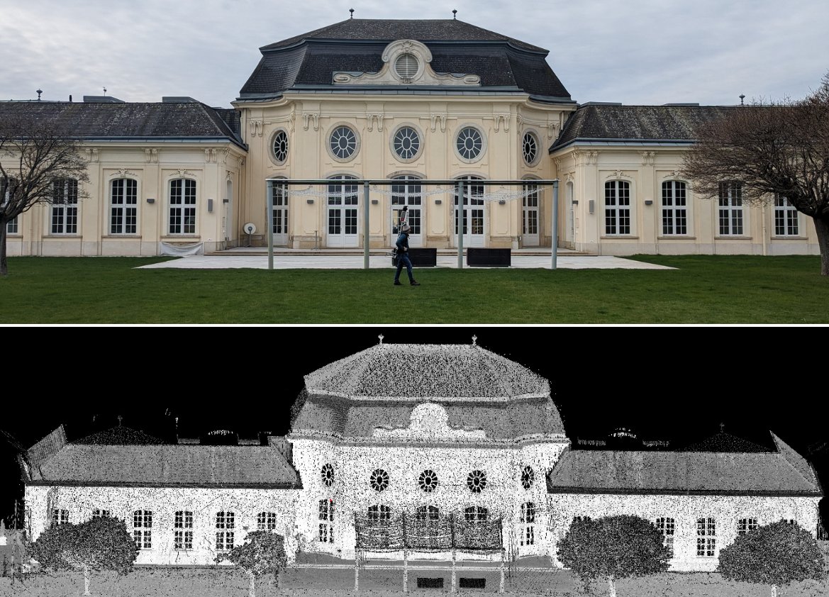
357K Followers 117 Following Understanding our planet to benefit humankind. Find us at https://t.co/KaKUU3pwii and https://t.co/c9lqAKJ7iO. Verification: https://t.co/UDYj516PXdSome final experiments for my dissertation project of an automated building documentation workflow with mixed reality interaction - soon to be finished! including automated processing of @RIEGL terrestrial laserscans and joint processing in @RealityCapture_
Adam Pałęcki is making impressive strides in his #internship with us @geodepartment! He's diving deep into assessing Velodyne scanner accuracy, comparing real and simulated observations. Here's what he's up to:
Oh no, we've got a competition!

Something exciting is in the works! Something that consists of Raspberry Pis and is similar to a #supercomputer. Something like the @VSCluster but way smaller ⚡️⚡️⚡️

Support your daughter's interest in technology! Together with our colleagues from Higher Geodesy, we were glad we could host one of the @WienerToechter workshops at @tu_wien to give young girls some insights in our job as geodesists 🦸♀️👩💻👩🏭
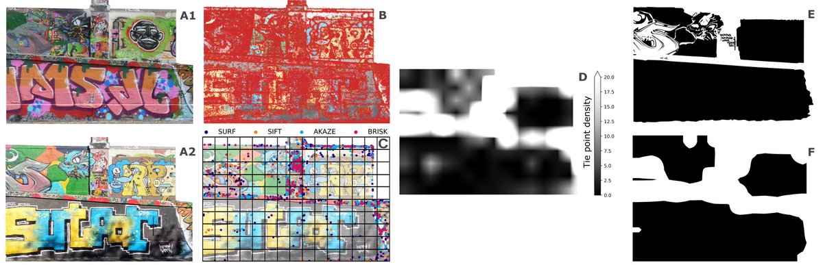
📢🚨Excited to share our latest @WileyGlobal paper on #graffiti documentation! 📷Explore our novel #GoPro-based #change detection method for #CulturalHeritage 👇👀 doi.org/10.1111/phor.1… @9bewild6 @NorbertPfeifer @GJJVerhoeven @geodepartment @URC_UGent
Die Anmeldung für den Österreichischen Klimatag ist noch bis 11.3. geöffnet. Heuer findet dieser an der TU Wien statt.
Jetzt zum #Klimatag24 anmelden: ccca.ac.at/dialogformate/… 🌍 Der Österreichische Klimatag ist eine wissenschaftliche Tagung, mit dem Ziel einen Überblick über die aktuellen österreichischen Forschungsaktivitäten in den Bereichen Klimawandel und Transformation zu geben!

Was hat der Forschungsbereich Geodäsie mit Google-Maps und unserem Alltag zu tun? TUW-Geodät Johannes Böhm erklärt es im Interview. brnw.ch/21wHTFQ
🧭 Navigieren in schwierigem Gelände und das „Zwei-Körper-Problem", das Wissenschaftler_innen haben, wenn sie eine Familie gründen (wollen): Beides beschäftigt die Geodätin Jelena Gabela Majic, Postdoc an der TUW. 👉 "Woman in Science"-Interview: tuwien.at/tu-wien/aktuel…
Another cool example of the work of our @photo_TUW colleagues @geodepartment
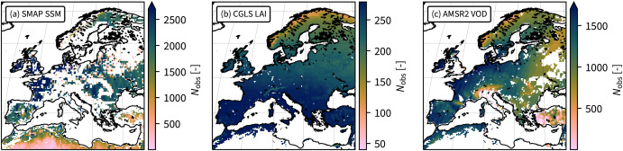
The @CopernicusECMWF European State-of-the-Climate report is out! Again a great soil moisture section by @CLIMERS_GEO @planet @eodc and @ECMWF : climate.copernicus.eu/esotc/2023/soi… Spot the differences between #reanalysis and #satellite data:
🚁✨ We successfully used our new #DJI M350 RTK #drone with a 45 MPIX #Zenmuse P1 RGB camera for the first time! 📸 We captured the Rochus Chapel (Mannersdorf/Lower Austria) with nadir and oblique aerial images and created this animation from them! #EarthDay2024
Lange Nacht der Forschung: Am Campus Science Center öffnen wir unsere Großraumlabors und bieten mehrere Mitmachstationen an. Von Supercomputer bis Augmented Reality, von Elektromobilität bis Sensorik, u.v.m. 👉 24. Mai, ab 17 Uhr. Fotos: TU Wien │ Matthias Heisler


#EGU2024 day 3 is starting🗣️ 9⃣ contributions from our side done✅ 5⃣ more to come📢 Check them out on tuwien.at/mg/geo/climers…
Irene receiving the @EuroGeosciences OSSP award of the hydrological division! @ismn_earth @ESA_EO #frm4sm @climers
Super inspiring #EGU24 presentation by Wolfgang Wagner @geodepartment on the start of soil moisture remote sensing "the purpose of the instrument (ERS scatterometer) was wind mapping over oceans, we were lucky it was switched on over land at all to avoid the instrument cooling"
#EGU24 kicked off in #Vienna - a homerun for our group, as always. This year, we're prominently featured in session BG9.2, focusing on RS for forest applications. Drop by and say hi Wednesday! 👋👇meetingorganizer.copernicus.org/EGU24/session/…
The EuroCarto 2024 abstract submission deadline has been extended to April 24th. We look forward to your submissions and to welcoming you to Vienna! #EuroCarto2024
W H A T A S U C C E S S! 💫 Today at our annual Geo-Day @geodepartment we let young and older kids dive into the wonderful word of geodesy 😍
Thrilling news! 🎉 @GMandlburger is now University Professor of Optical Bathymetry. Congratulations, Gottfried! 🌊📷
Gottfried Mandlburger is our new Professor of Optical Bathymetry @photo_TUW Welcome! tuwien.at/en/mg/geo/news…
I'm very proud to announce that Irene and the @CLIMERS_GEO @ismn_earth team won the poster award at the @_CCCA_ Austrian climate conference! @ESA_EO
Trends for United States
You might like