Mukhtar Ahmad @Mukhtar21134651
Meteorologist at India Meteorological dept. Srinagar Srinagar Joined December 2022-
Tweets190
-
Followers2K
-
Following91
-
Likes138
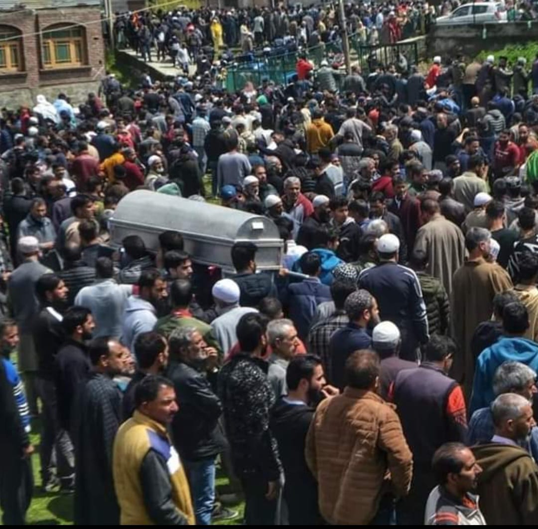
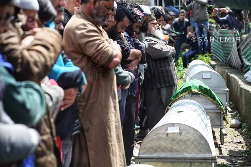
Very sad and tragic. Heartfelt condolences
Very sad and tragic. Heartfelt condolences


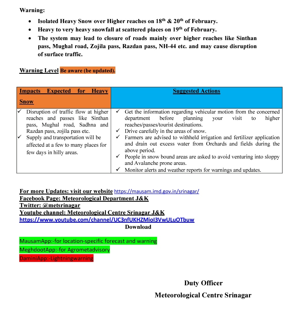
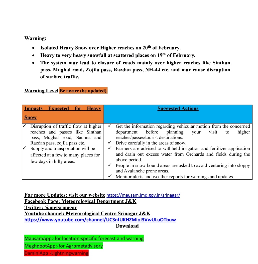
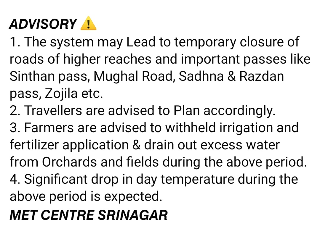
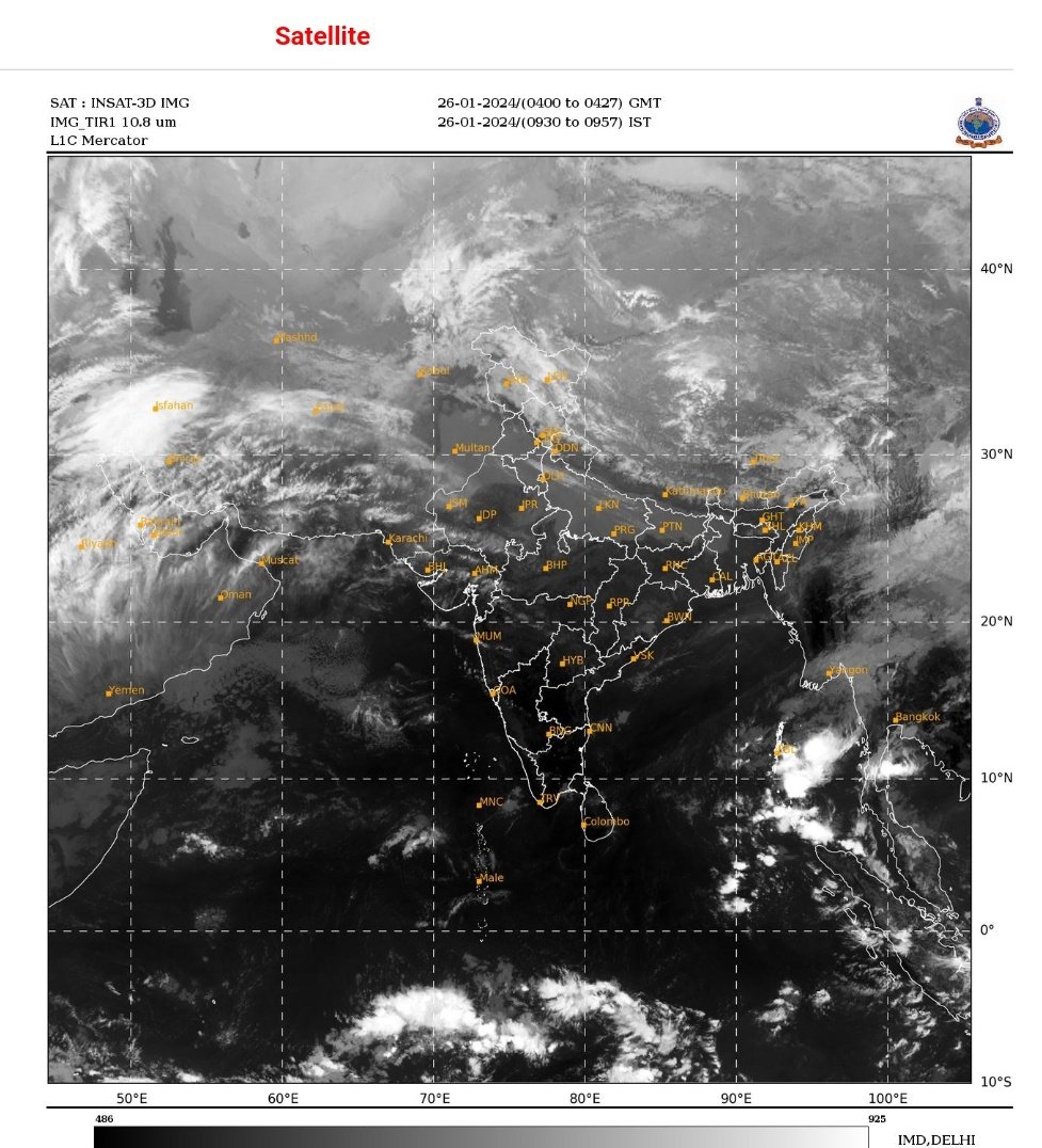
●As expected, Widespread Moderate to hvy Rain/Snow recieved over most places with hvy to very hvy Snow over higher reaches of KMR & PirPanjal of JMU Div. ● Gusty winds with Hailstorm recieved over plains of J&K. ●Landslides/Mudslides & shooting stones at multiple places.

●As expected, Widespread Moderate to hvy Rain/Snow recieved over most places with hvy to very hvy Snow over higher reaches of KMR & PirPanjal of JMU Div. ● Gusty winds with Hailstorm recieved over plains of J&K. ●Landslides/Mudslides & shooting stones at multiple places. https://t.co/VVHKghSDTd

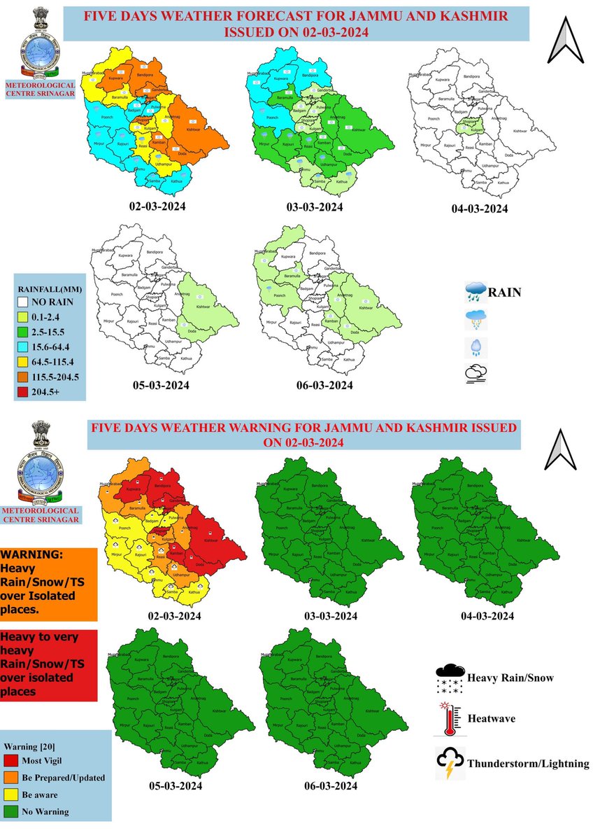
●Moderate to heavy Rain/Snow at most places with hvy to very hvy Snow over few higher reaches of KMR & PirPanjal Range of JMU Div. ●Strong gusty winds over plains of J&K. ● Possibility of Landslides/Mudslides & shooting stones at few places. ● Stay safe & be alert ⚠️
●Moderate to heavy Rain/Snow at most places with hvy to very hvy Snow over few higher reaches of KMR & PirPanjal Range of JMU Div. ●Strong gusty winds over plains of J&K. ● Possibility of Landslides/Mudslides & shooting stones at few places. ● Stay safe & be alert ⚠️ https://t.co/JShnUN09ka
●Another major Wet Spell from 29th evening till 3rd March f/n. ●Higher reaches of KMR & PirPanjal Range of JMU Division may recieve very hvy Snow on 1 & 2 March. ●Few plains and lower reaches of J&K may receive Heavy Rain/Snow with thunder/Lightning & Gusty winds(30-40 KMPH

●Another major Wet Spell from 29th evening till 3rd March f/n. ●Higher reaches of KMR & PirPanjal Range of JMU Division may recieve very hvy Snow on 1 & 2 March. ●Few plains and lower reaches of J&K may receive Heavy Rain/Snow with thunder/Lightning & Gusty winds(30-40 KMPH https://t.co/CHDYZfHGjv

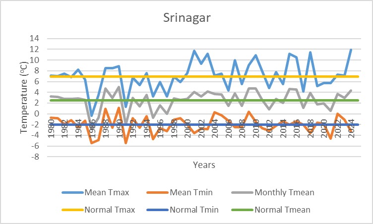
●Bone chilling Cold over entire Ladakh after the recent Wet spell. ●Drass & Zanskar stations showing Minimum temperature of -24.9°C & -25.3°C on 24 Feb and Maximum temperature of -7.9°C & -4.1°C on 23rd Feb.
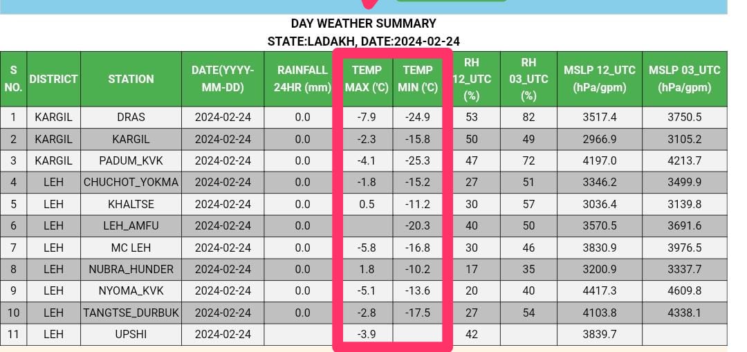
●Bone chilling Cold over entire Ladakh after the recent Wet spell. ●Drass & Zanskar stations showing Minimum temperature of -24.9°C & -25.3°C on 24 Feb and Maximum temperature of -7.9°C & -4.1°C on 23rd Feb. https://t.co/ybgKSpKLEP

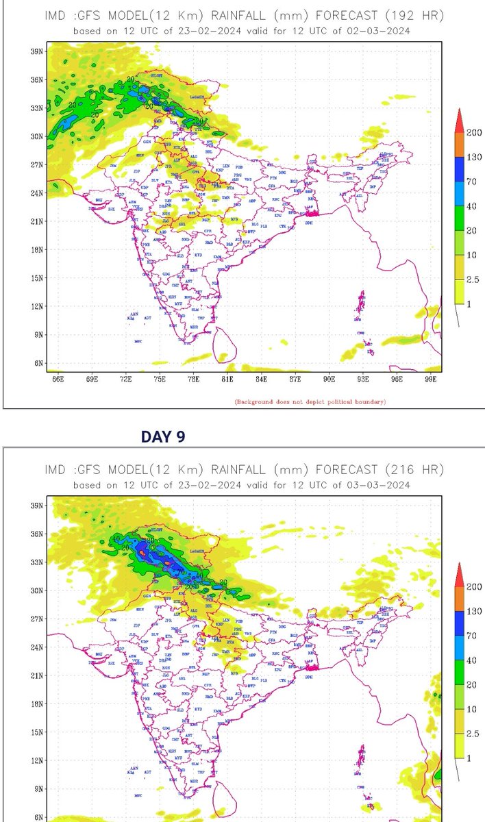
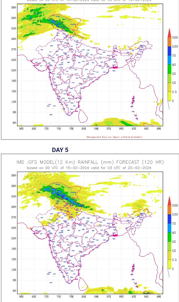
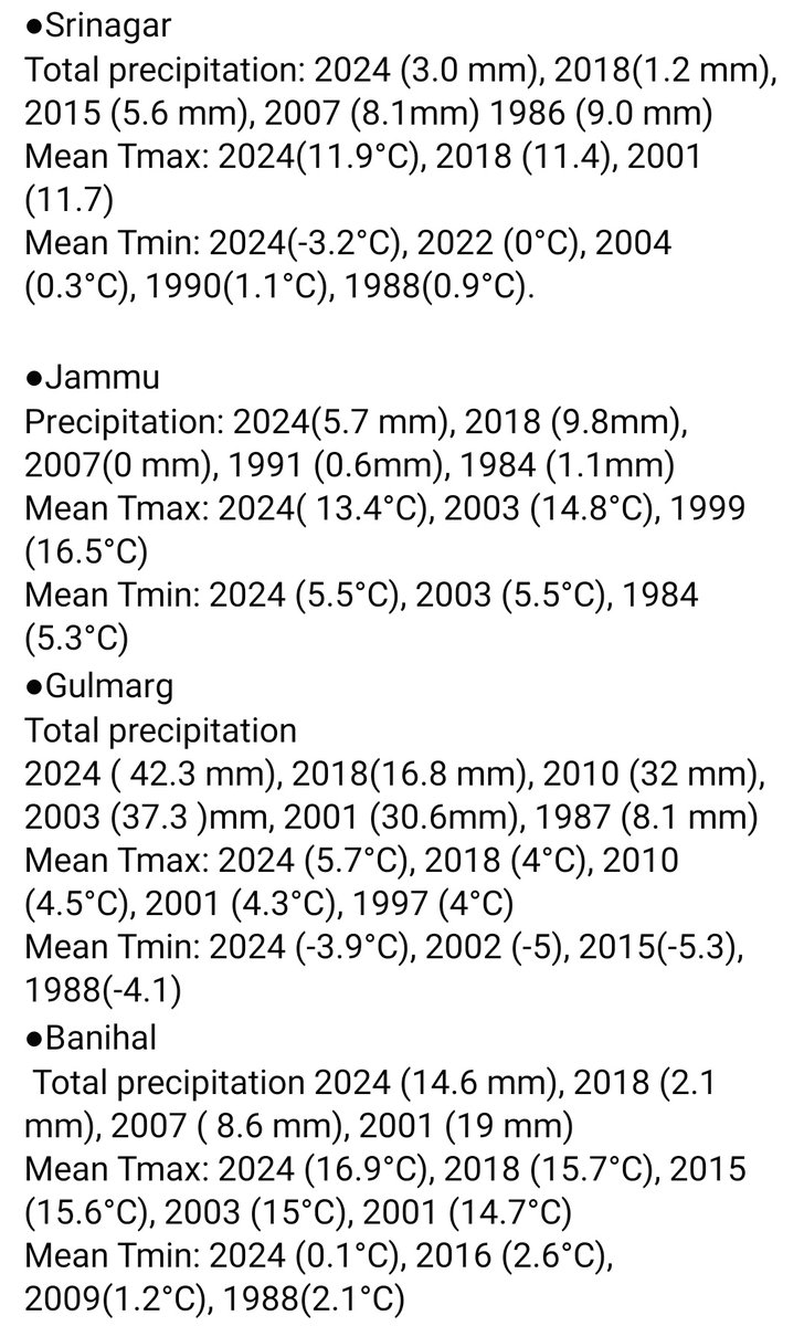
●As per IMDs extended range forecast,above normal precipitation is expected during 2nd & 3rd week (29 Feb-7 March) & (7-14 March). ●Trends of different models indicating Light to moderate Rain/Snow at most places with isolated heavy Rain/Snow likely during 2nd & 3rd March.

●As per IMDs extended range forecast,above normal precipitation is expected during 2nd & 3rd week (29 Feb-7 March) & (7-14 March). ●Trends of different models indicating Light to moderate Rain/Snow at most places with isolated heavy Rain/Snow likely during 2nd & 3rd March. https://t.co/CtdMZLfzjp

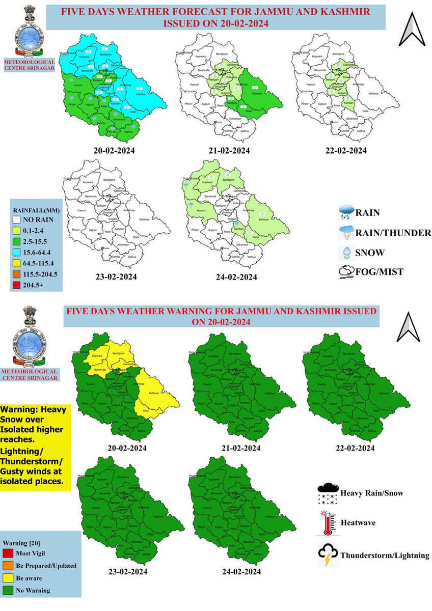
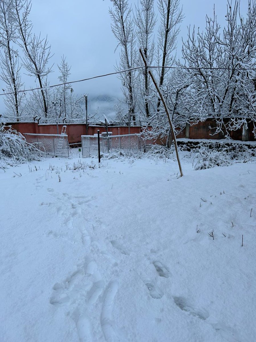
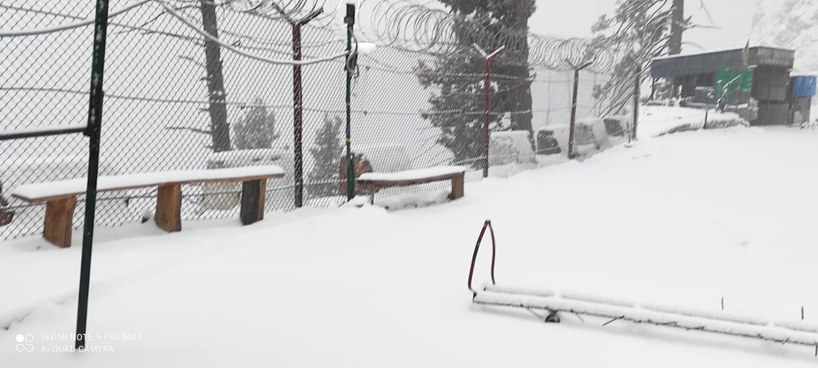
●Observed weather during 18-21 Feb: ●Middle & Higher reaches of KMR & PirPanjal Range of JMU Division recieved 3-5 Ft Snow depth. ●Plains & Lower reaches (0.5-1.5 Ft) ●Stay away from avalanche Prone areas & Steepy slopes. ● Another Minor wet spell during 27-28 Feb.

●Observed weather during 18-21 Feb: ●Middle & Higher reaches of KMR & PirPanjal Range of JMU Division recieved 3-5 Ft Snow depth. ●Plains & Lower reaches (0.5-1.5 Ft) ●Stay away from avalanche Prone areas & Steepy slopes. ● Another Minor wet spell during 27-28 Feb. https://t.co/fg2oLZuhw5

●Recent flurry of Snow temporarily affected lives over middle & higher reaches of J&K. Video from Tulail area of Bandipora (Video credit Bashir Ahmad Lone) ●Current spell likely to continue till today evening at many places and gradual improvement thereafter.
●Recent flurry of Snow temporarily affected lives over middle & higher reaches of J&K. Video from Tulail area of Bandipora (Video credit Bashir Ahmad Lone) ●Current spell likely to continue till today evening at many places and gradual improvement thereafter. https://t.co/pFyrNprTLq

Snow storm over Sonamarg during today evening. Stay away from slopy areas and don't venture in Avlanche prone areas. #Besafe #StaySafe #Snowstorm #Heavysnow #Avlanches
Snow storm over Sonamarg during today evening. Stay away from slopy areas and don't venture in Avlanche prone areas. #Besafe #StaySafe #Snowstorm #Heavysnow #Avlanches https://t.co/KcUK1vVvxS
●Snowing moderate to heavily since yesterday over higher reaches and raining over plains of KMR & JMU Div ●Likely to continue till tomo late A/N and gradual improvement thereafter ●Snow depth (ft) over higher reaches Machil-3 Tulail-3 Sonamarg-3 Gulmarg bowl-2 Doda/Kishtwar-2
●Snowing moderate to heavily since yesterday over higher reaches and raining over plains of KMR & JMU Div ●Likely to continue till tomo late A/N and gradual improvement thereafter ●Snow depth (ft) over higher reaches Machil-3 Tulail-3 Sonamarg-3 Gulmarg bowl-2 Doda/Kishtwar-2 https://t.co/n9U4k5z3u0


Brace up for the wet spell starting from the 17th (night) to 21st Forenoon. As per IMD's 4 week extended range forecast, above normal precipitation likely over J&K and adjoining areas during 3rd week (29 Feb to 7th March) & near normal precipitation in the 4th week (7-14 March).
Brace up for the wet spell starting from the 17th (night) to 21st Forenoon. As per IMD's 4 week extended range forecast, above normal precipitation likely over J&K and adjoining areas during 3rd week (29 Feb to 7th March) & near normal precipitation in the 4th week (7-14 March). https://t.co/TcpUNA4Gtm


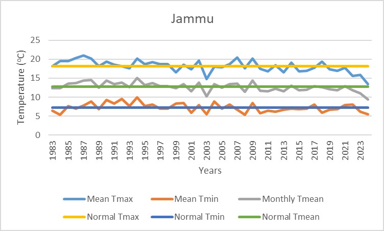
Contrasting patterns Mean Maximum temp observed over Srinagar (11.9°C) is 5.2°C above normal Tmax (6.7°C) & Jammu (13.4°C) is 5.2°C below normal Tmax (18.6°C) during the Jan 2024. Prolonged Dry spells over Valley & consistent Fog over Plains of Jammu are the main reasons.
Contrasting patterns Mean Maximum temp observed over Srinagar (11.9°C) is 5.2°C above normal Tmax (6.7°C) & Jammu (13.4°C) is 5.2°C below normal Tmax (18.6°C) during the Jan 2024. Prolonged Dry spells over Valley & consistent Fog over Plains of Jammu are the main reasons.

Successfully installed & tested Automatic Snow Gauge observation with the manual observations during the recent snowfall @metsrinagar. Congratulations to the entire team @ClimateImd, @Indiametdept, @moesgoi, @Hosalikar_KS, @PramodS40291443 Installation at Pahlgam is under process
Successfully installed & tested Automatic Snow Gauge observation with the manual observations during the recent snowfall @metsrinagar. Congratulations to the entire team @ClimateImd, @Indiametdept, @moesgoi, @Hosalikar_KS, @PramodS40291443 Installation at Pahlgam is under process

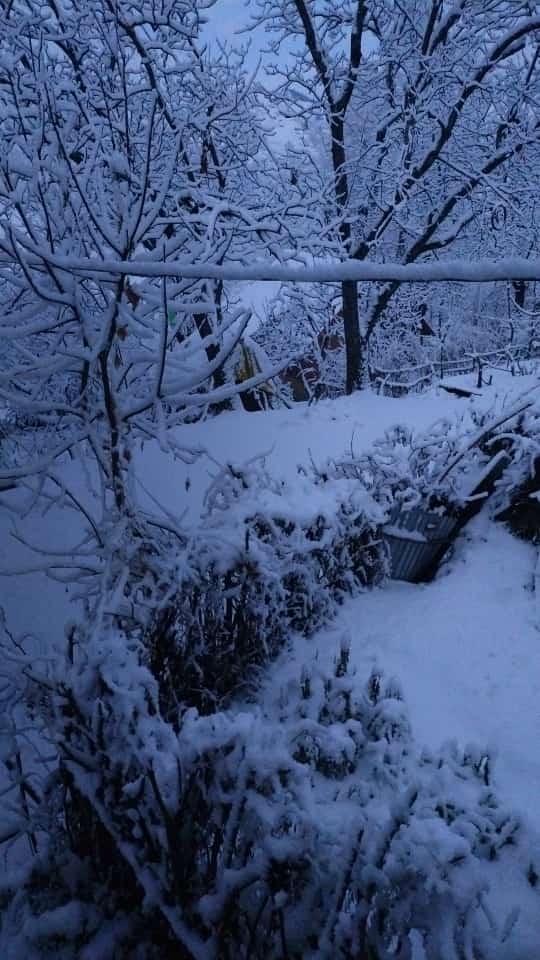
●Snowing moderately since today early morning at most places of KMR DIV & upper reaches of JMU Div & likely to continue till today A/N/ late A/N and gradual improvement thereafter. ●Snow depth: (2-6 inches) in plains & Lower reaches and 8-12 inches in middle and higher reaches.
●Snowing moderately since today early morning at most places of KMR DIV & upper reaches of JMU Div & likely to continue till today A/N/ late A/N and gradual improvement thereafter. ●Snow depth: (2-6 inches) in plains & Lower reaches and 8-12 inches in middle and higher reaches. https://t.co/feXbF5N0Kp


After a prolonged Dry spell in #chillaikalan, the much awaited fresh snowfall experienced since past 3 days over most parts of KMR Div rejuvenated the #meadows #Hills #Horticulture #Agriculture #streams #rivers & #glaciers. ●Another spell most likely from 3rd evening to 4th AN
After a prolonged Dry spell in #chillaikalan, the much awaited fresh snowfall experienced since past 3 days over most parts of KMR Div rejuvenated the #meadows #Hills #Horticulture #Agriculture #streams #rivers & #glaciers. ●Another spell most likely from 3rd evening to 4th AN https://t.co/dKNQDW5H1A


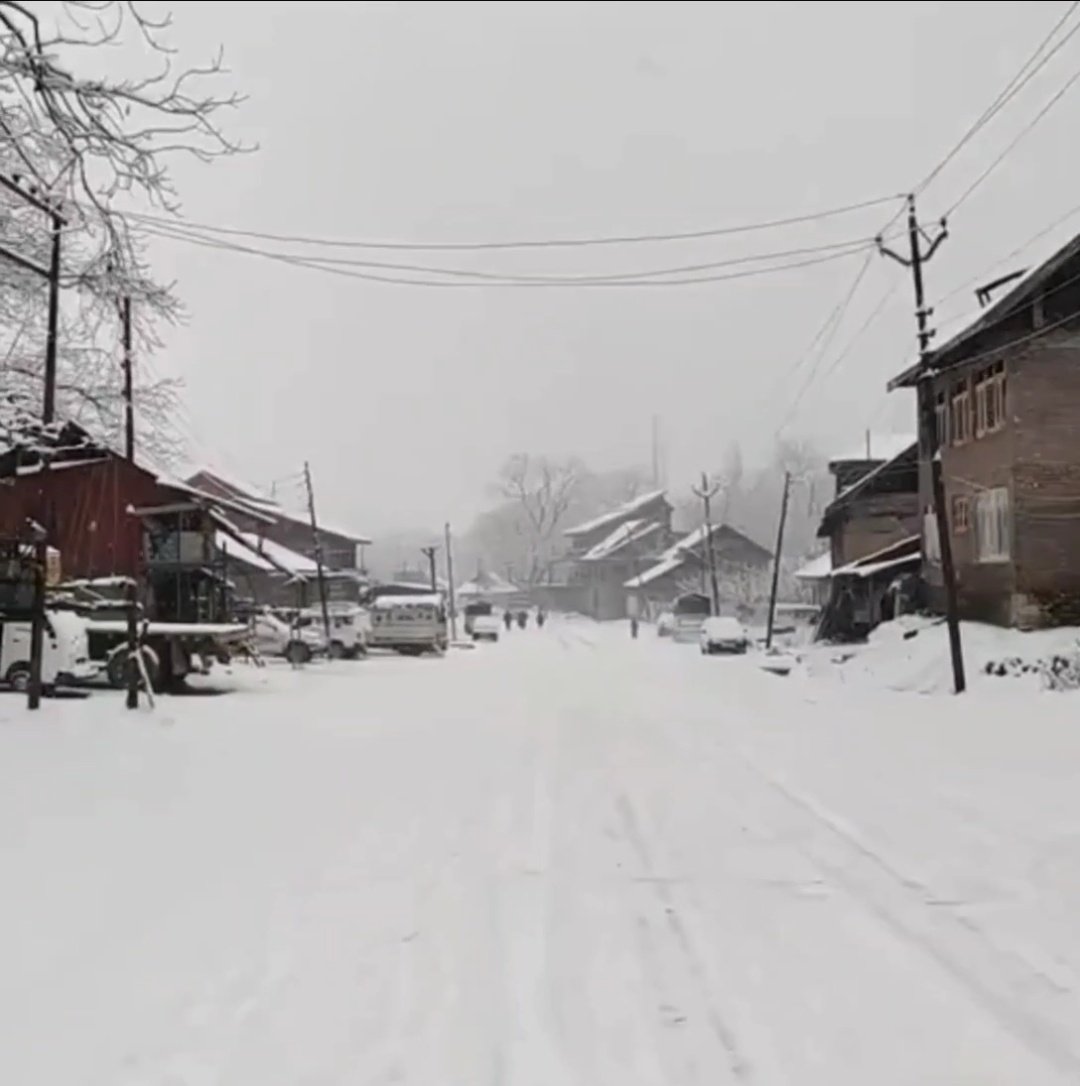
Light to moderate snow observed over many parts of Kashmir Division (6-8 inches) in plains of North, Nwestern and South Kashmir with heavy snowfall over few higher reaches. Jammu Division also received light to moderate Rain with light snow over isolated middle & higher reaches.
Light to moderate snow observed over many parts of Kashmir Division (6-8 inches) in plains of North, Nwestern and South Kashmir with heavy snowfall over few higher reaches. Jammu Division also received light to moderate Rain with light snow over isolated middle & higher reaches. https://t.co/nKbv0dLfBu

Fresh 8 inches of Snow recorded at Sonamarg Video credit (Shabir Ahmad Bhat) #winterwonderland #Snow #Sonamarg
The epitome of winter Snowfall in Gulmarg Video credit (Gh Mohd Bhat)
The epitome of winter Snowfall in Gulmarg Video credit (Gh Mohd Bhat) https://t.co/5xkulv1h3b


●As predicted earlier, light Rain/Snow at few higher reaches observed during today early morning & improvement towards afternoon is expected. ●Possibility of intermittent light to moderate Rain/Snow at many places during 28 Jan to 3rd February.
●As predicted earlier, light Rain/Snow at few higher reaches observed during today early morning & improvement towards afternoon is expected. ●Possibility of intermittent light to moderate Rain/Snow at many places during 28 Jan to 3rd February. https://t.co/nDbi7rEuKU

Maximum temperature of 9.3°C was observed in Drass Kargil and 8.9°C in Jammu today on 13th Jan.

Maximum temperature of 9.3°C was observed in Drass Kargil and 8.9°C in Jammu today on 13th Jan. https://t.co/ewBALzSSVP

Zahid Malik @zahid9678
0 Followers 49 Following
Mohd Ashraf @MohdAshraf7743
0 Followers 11 Following


AijazMalik @DigitalChinar
119 Followers 598 Following Aijaz Malik Digital and Online Marketing https://t.co/JRvbE26EPN marketing with solid experience in developing PPC/SEO/SMO campaigns.
zahid @zahid5656194892
6 Followers 145 Following P.G. https://t.co/jyFhYunpxQ in Jammu and Kashmir. Kashmir the paradise on earth 🌎🌎
Ajaz Shah @ShahAjaz123
4 Followers 102 Following Presently working in J&K Education Department as Teacher

GH MOHD @GHMOHD396690
19 Followers 98 Following
Dr Aijaz Peerzada. @DrAijazPeerzada
68 Followers 458 Following
Mushtaq Ahmad @Mushtaq24345032
1 Followers 62 Following
Dr. Umar Nazir Tibet .. @untbaqal
1K Followers 1K Following Director Labaika Group BABS (Hons ) University of West London MBA(Hons)Middlesex University London FIBS LSE-UK Ph.D (HC) CPU USA
Tariq Hazari @HazariTariq
116 Followers 2K Following #TSM| #Dentoshine | #Jammu & #Kashmir | أَشْهَدُ أَنْ ﻻﹶ إِلَٰهَ إِﻻﱠ اللَّهُ وَحْدَهُ ﻻﹶشَريكَ لَهُ وَأَشْهَدُ أَنَّ مُحَمَّدًا عَبْدُهُ وَرَسُولُهُ

Parvaiz Dar @darparvazahmad1
0 Followers 8 Following
Islambadech @islambadech
0 Followers 24 Following

Maliktweets🏏 @Maliktweets6
52 Followers 1K Following sports lover, music listener, and a friend of humanity

Gulzar Ahmad @AOGulzar
0 Followers 117 Following

Towseef Akram @Towseef_akram1
7 Followers 62 Following
Shahnaz Ahmad Rather @ShahnazAhmadRa1
2 Followers 49 Following
zubair zubair @zubairzuba87697
0 Followers 27 Following
Syed @Syed19755816073
362 Followers 4K Following
Adil Ganie @AdilGanie844911
1 Followers 69 Following
SelenaCharley @7Q3fw9g9HipB0o
5 Followers 213 Following
Naseer Ahmad @BeiingNaseer
107 Followers 230 Following I fall, I rise, I make mistakes, I live, I learn, I've been hurt but I am alive.i am human, I am not perfect but I am thankful.
Shaber Mehdi Khan @shaber0805
4 Followers 216 Following
Arshid Khanday @ArshidKhanday6
4 Followers 59 Following
Reyaz Bhat @ReyazBhat2
57 Followers 204 Following


Syed Ifra @SyedIfra6
7 Followers 150 Following Two things define you, your patience when you have nothing, your attitude when you have everything 🍁
SYED ISHFAQ @Ishfaq13081
23 Followers 456 Following I am a Ph. D. doctor in the field of Statistics interested in Research, teaching, Statistical Analysis and R Programmer.
Nargis Jafri @nargis_jafri
8 Followers 12 Following I mentor students to be more productive by solving their issues related to studies, time management, productivity & success.

Thrifty Malik @malik_654321
47 Followers 1K Following Matlab ye ke bhola nhi hu Ye bhi nhi ki yaad ati ho ❤️
Javeed Bin Nabi @Javeedbinnabi
3 Followers 119 Following
ISHRAT AHMAD BHAT @ishratbhat902
1K Followers 5K Following Politician✴️🌏. | chasing the dreams, one step at a time! retweets not necessarily endorsements.

sarim @sarim885437
2 Followers 84 Following
Tenzin Pema (བས�.. @tenzin_pema
1K Followers 2K Following Journo | Occasional poet & painter | Views expressed are my own. RTs not endorsements.
Dr. Sonam Wangchok @sonam_wangchok
3K Followers 7 Following Cultural Activist | Independent Researcher | Social Worker | Working for mountain communities .. https://t.co/UHRULIjLzE
Ashia Lone @LoneAshia
3 Followers 32 Following
Nazir Ganaie @Nazirkashmiri
6K Followers 1K Following Journalist/ Filmmaker/ Artist/ Multimedia Lead at Kashmir Observer / Previously Greater Kashmir, Rising Kashmir, Barcroft Media.
Parvaz Ahmad @a08699441
12 Followers 292 Following
K S Hosalikar @Hosalikar_KS
41K Followers 194 Following Scientist - G, Head-IMD Pune, India Meteorological Department. Tweeting in personal capacity. Mission:To take weather updates/alerts to last mile in real time

Mustafa Haji @Mustafa_haji_
1K Followers 726 Following Lawyer. Law and Policy. Interested in Ladakh and J&K. NALSAR (2013)
Faz Lul Haseeb @FazLulhaseeb
7K Followers 1K Following IAS 2018. J&K. Former CEO Urban development & Director Tourism, Kashmir. Presently Development Commissioner Shopian!


Madhavan Rajeevan @rajeevan61
16K Followers 956 Following Former Secretary, MoES. Vice Chancellor, Atria University Interest in Monsoon Research Tweeting in my personal capacity. Re-tweets or Likes not endorsements
Amin polo @Aminpolo9
222 Followers 342 Following Social worker and promoting polo and winter sports in Drass (the second coldest place in the world) ladakh
Irfan Rashid @irfansalroo
1K Followers 414 Following Assistant Professor, Department of Geoinformatics, University of Kashmir. Interests: Cryosphere, Kashmir
Aamir Ali @er_aamirali
1K Followers 2K Following Safety First is my motto. Am committed to building a resilient future by empowering the rural communities. Tweets are personal.
Ground Report @GReportIndia
2K Followers 70 Following We focus to bring underreported environment, health, and gender-specific stories from the margins of India.
Prof. Eliot Jacobson @EliotJacobson
75K Followers 389 Following Retired professor of mathematics and computer science, author of 4 books: 3 on casino games & 1 poetry book. Now I volunteer, walk a lot & feed local critters.
The Asian News Hub @AsianNewsHub
8K Followers 1 Following News website operating from #Kashmir, which connects you around the world about daily happenings.
𝐁𝐨𝐫𝐝𝐞�.. @BROindia
52K Followers 139 Following A Premier Organisation constructing and maintaining infrastructure in the most challenging terrain of India- Playing a pivotal role in the development of India.
Rayees Mohiuddin @RayeesMohiuddin
4K Followers 22 Following Actor Producer and RJ @Redfmindia Host KBC Kashmir.
RJ Sameen @RJSameenKhan
9K Followers 459 Following Views are my own, Engineer turned Radio Jockey. Working with @redfmindia, srinagar station, B+ blood donor


Mudasir Dar @muddieco_JKES
130 Followers 2K Following Econometrics Educator turned Planning Conformist, charting a course through the choppy seas of policy with a pinch of wit. Views expressed are personal.
Abid Nazir (ءابد) @AbidNaz96345082
96 Followers 287 Following

Yaseen Sabri Drass @SabriDrass
218 Followers 265 Following Freelance writer Former President Youth/ Students Association Drass V/C Foundation Help Group Drass
IMD Chandigarh @IMD_Chandigarh
3K Followers 37 Following मौसम केंद्र,चंडीगढ़ भारत मौसम विज्ञान विभाग Official page of Meteorological Department (Mausam Kendra), Chandigarh. Weather forecasting and information.
RWFC New Delhi @RWFC_ND
10K Followers 35 Following Weather forecasts for Delhi NCR and forecasts for NW India through Met Centers in J&K, HP, Uttarakhand, Punjab- Haryana, Rajasthan & UP. [email protected]
World Meteorological .. @WMO
199K Followers 1K Following News from the World Meteorological Organization and WMO Members.
Irrigation & Flood Co.. @ifckashmir
5K Followers 23 Following Official Twitter account of the Irrigation & Flood Control Department of Kashmir


Srinagar Municipal Co.. @SMC_Srinagar
29K Followers 53 Following Official Twitter handle of the Srinagar Municipal Corporation (SMC). Grievances: @SMC_24x7 📞+911942474499 📞18001807038 📞 +911942470465

Kashmir Weather @Kashmir_Weather
35K Followers 144 Following Faizan Arif, Hunting Western Disturbances | Columnist @kashmirobserver | Featured in @htTweets @timesofindia | Pursuing MSc Applied Physics and MA (J&MC)
Majid Maqbool @majidmaqbool_
130 Followers 117 Following
Mukhtar Khoshi @khoshibaroo
12 Followers 185 Following
Subzar Bashir @plannersubzar
99 Followers 1K Following Urban & Regional Planner, CEPTian, Urban Geographer, Kashmiri
mir gowhar @mirgowh90794963
1 Followers 83 Following


Er Riyaz Haji @ErRiyazHaji1
35 Followers 524 Following
Bappa Das @bappaiari
6 Followers 54 Following
𝕴𝖒𝖙𝖎𝖞�.. @ImtiyazRamzan5
12 Followers 262 Following No Matter Strong powerfull rich Good looking you are You will Taste Death.Before It's Too late Return.
Sajjad Hussein ( Bob) @BobSajjad
155 Followers 150 Following Teacher, Traveller, Thinker, Educationist and Reformist. Co-Founder WAVE Ladakh Foundation (We are volunteers for Education).Trends for United States
You might like