
DroneView Tech @DroneViewTech
Aerial Mapping and GeoSpatial Services DroneViewTech.com Michigan Florida Texas Calif Joined August 2014-
Tweets1K
-
Followers2K
-
Following1K
-
Likes6
DroneView Year in Review and 2023 Outlook droneviewtech.com/blog-posts/dro…
DroneView Expands LiDAR and Photogrammetry Aerial Mapping Team droneviewtech.com/blog-posts/dro…
DroneView's Jason Heywood is presenting - High Accuracy Aerial Mapping at the Michigan Society of Professional Surveyors Conference droneviewtech.com/blog-posts/dro…
DroneView - Michael Singer, Jason Heywood and Michael Crain - look forward to seeing you next week in Denver at GeoWeek


DroneView: Year in Review and 2022 Outlook droneviewtech.com/blog-posts/dro…
DroneView expands LiDAR and Photogrammetry Aerial Mapping team droneviewtech.com/blog-posts/dro…
Kevin Morgan Joins DroneView Technologies as Business Development Associate droneviewtech.com/blog-posts/kev…
Commercial UAV NEWS: Has the Evolution of the Commercial Drone Industry Created Opportunities or Cultivated Misconceptions? droneviewtech.com/blog-posts/com…
LiDAR + Photogrammetry Workflows droneviewtech.com/blog-and-news/…
Jason Heywood Promoted to President of DroneView Technologies droneviewtech.com/blog-and-news/…
DroneView is HIRING - Geospatial LiDAR-CAD Technician - bit.ly/LiDARtech - Sales/Business Development - lnkd.in/eyqY4_n #LiDARtech #TerraScan #Photogrammetry #AerialMapping

DroneView Year in Review and Outlook for 2021 droneviewtech.com/blog-and-news/…
Michael Crain Joins DroneView Technologies as Director of Geospatial Services droneviewtech.com/blog-and-news/…
DroneView - Planning for the "New Normal" droneviewtech.com/blog-and-news/…
Project Spotlight: FAA approved Airport Layout Plan (ALP) & Airport Mapping droneviewtech.com/blog-and-news/…
DroneView Supports Surveyors with Aerial Mapping and Geospatial Services droneviewtech.com/blog-and-news/…
DroneView Technologies: Year in Review and Outlook for 2020 droneviewtech.com/blog-and-news/…
Project Spotlight: Stockpile Inventory Measurement and Custom Reporting droneviewtech.com/blog-and-news/…
Project Spotlight: Electric Utility Mapping + Inspection droneviewtech.com/blog-and-news/…

Unmanned Systems Tech... @UnmannedSystem
32K Followers 5K Following UST provides the latest #news and #technological developments in #unmanned/#uncrewed including #drones #AUV #UGV #robotics.

Draganfly Inc. @DraganflyInc
6K Followers 3K Following 25+ yrs in drones & software | NASDAQ: $DPRO #DFLYWithUs
Byte Drone Center @ByteDroneCenter
778 Followers 845 Following We are the 1st Drone Training School in the NJ area with the focus on how to become a FAA Certified Pilot In Command to enter into the commercial drone industry
InViewAssets | Take a... @InviewAssets
530 Followers 1K Following 🇬🇧InView is a technology enterprise specialising in precision imaging of infrastructure and landscapes. Reduce costs | Increase productivity | Improve safety

BARNG'ETUNY @EtunyJob
332 Followers 2K Following GIS Analysis & Spatial Data Management; Drone Mapping & UAV Operations; Remote Sensing & Multispectral Analysis; ArcGIS & Geospatial Modeling; Photogrammetry &
Santhosh Raja @Santhosu
6 Followers 1K Following
Cluaran @Cluarando1
10 Followers 237 Following
tina Zhong @tinaZhong2025
0 Followers 325 Following Emial : [email protected] Tel : +86 158 0256 4150
Ellyy @ChillEllyy
218 Followers 2K Following Horny bartender. Watch me while i pour it all down Don't forget to check the link to my page 😮💨⬇️
òshó @oshojoseph17
33 Followers 500 Following A little guy with high intelligence, into tech stuff.....want to know more...... Get to know me
सर्वेश �... @Kokancha_SAvtYA
39 Followers 118 Following राज प्रेमी | कट्टर मऱ्हाटी | माजी संघ स्वयंसेवक


NR23 Design @DesignNR23
106 Followers 999 Following
McQuysea @McQuysealOOLPw
18 Followers 786 Following
Roland @takeishiwa23526
67 Followers 7K Following
Carmen Che @Che889900
10 Followers 423 Following
Gerry Huskey @gerry_huskey
36 Followers 251 Following Licensed UAS/Commercial Drone Pilot. Photographer/Videographer. Based out of North Carolina.
Geospatial @Geospatialz
2K Followers 4K Following Geopolitics | Defense | Strategic Affairs | Viral Trends | Sports | Cricket 🏏 | 🌎🗺️🧭
Professional Drone Im... @prodroneimagery
6 Followers 121 Following 🏆 LOCAL ILLAWARRA BUSINESS AWARDS FINALISTS 📸 HIGH RISK SAFETY & COMPLIANCE SPECIALISTS 🏅 CASA‑Accredited/Certified REOC: 8871 ✨ $20M PL Insured
Don Henry @donhello2019
7 Followers 254 Following
EstherJones @XqWv1KJ1OJijXe
54 Followers 7K Following
Mostafa Fayek @mfyk
170 Followers 4K Following
Spatialmate Consultan... @spatialmate_uae
4 Followers 107 Following
DaveDroning 🥰 @DaveDroning2023
551 Followers 3K Following I'm Dave and I love flying Drones, living on the Isle of Wight on the south coast of the UK my passion is to make beautiful YouTube content of my home island.
Ajeet Drones @AjeetDrones
53 Followers 656 Following A Proprietary Drone manufacturing company with ISO & AS 9100 Certification has developed DGCA Compliant drone & Surveillance Drone for Defense Forces in India.

CITIzens WATch🇬�... @CITIzensWATch3
32 Followers 97 Following Love Christ Jesus my savior and love children, patriotic citizen of Ghana,

Osint12 @osint12_
85 Followers 538 Following Drone Enthusiast | OSINT Expert | Project Management Pro | Keen on Crypto-minimalism | Advocate for #Cybersecurity, #UAP, #Drones 🚀✨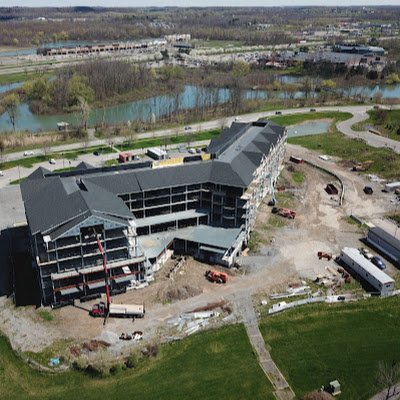

Bella B @BellaBi1125
124 Followers 242 Following
ICIT @ICIT_UNINA
8 Followers 97 Following
Bill Piniros @piniros
94 Followers 2K Following
[email protected] @GRIDEHD
1 Followers 589 Following
Elsight @elsight
723 Followers 2K Following Elsight's Halo provides connectivity and delivers absolute connection confidence for #drones and other unmanned systems.

Jerry @jerryspix
156 Followers 1K Following
JroneUSA @JroneUSA
78 Followers 176 Following Co-Founder and Drone Specialist at JDC Studios FAA Part 107 Certified Drone Pilot https://t.co/UHx2ouxrSR
Windmill Drone Servic... @foxcatflyers
7 Followers 64 Following Part 107 drone pilot, commercial construction foreman, interested in mapping and survey. #Drones #metaverse #3d
Nology Store32 @nologystore32
201 Followers 3K Following Welcome, I am a Professional Digital Marker and SEO Expert.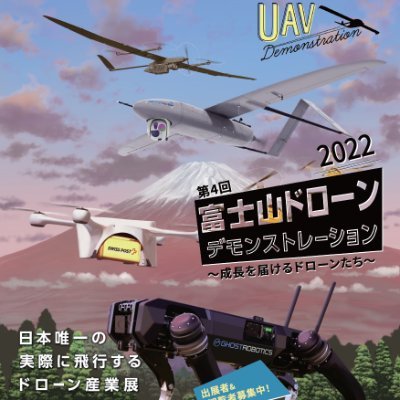
富士山ドローン... @fujisandronedem
1K Followers 5K Following 開催日時:2022年9月23日(金) 10:30-17:00 開催場所:御殿場市陸上競技場、御殿場市体育館 主催:慶應義塾大学SFC研究所ドローン社会共創コンソーシアム内 ドローンデモンストレーション実行委員会 共催:御殿場市 後援:(一財)防衛技術協会、駐日ラトビア共和国大使館、防衛省南関東防衛局
madaramenov @madaramonev
18 Followers 119 Following Drone Pilot / Competitive Racing / Aerial Videography, Photographer
Dron Malaysia 🇲�... @dronmalaysia
775 Followers 2K Following Berita dan perkembangan UAS semasa Malaysia.

DroneSherpaoBasti @AgySamundarhai
19 Followers 334 Following Drone #GoodTerrorists in #Sherpaobasti on #amenityplot @ 8/E #MuhammadAliSociety, #Bhutto k shalwar ka nara #PirPagara. Near homes of @arifalvi & @miftahismail
Ryan Bizarri @RyanBizarri
1K Followers 2K Following My new country single "That's Gold" is out now! Listen now on your favorite digital music platform! For all things Ryan Bizarri: https://t.co/8CSSz8pKCx
Tundra Drone @TundraDrone
708 Followers 453 Following Tundra Drone: 10,000 Lumen Technology ⚡ | World's brightest Automoving drone light for all DJI Mavic 3s and Mavic 2s | Let’s Illuminate the Sky!
Caio Cardinot @FreeSpeechYou
55 Followers 700 Following « Dans une libre république, il est permis à chacun de penser ce qu’il veut et de dire ce qu’il pense. » (Spinoza)
Giovanni (Divergent) @Achille240postC
187 Followers 674 Following Potevate scegliere fra il disonore e la guerra..avete scelto il disonore,avrete la guerra.
DJI @DJIGlobal
1.3M Followers 837 Following Official Twitter feed of DJI, the world leader in aerial and handheld cinematic solutions. Contact @DJISupport for customer support.
Unmanned Systems Tech... @UnmannedSystem
32K Followers 5K Following UST provides the latest #news and #technological developments in #unmanned/#uncrewed including #drones #AUV #UGV #robotics.
Sally French @TheDroneGirl
24K Followers 544 Following Geek girl who loves drones! Named @FortuneMag's Top Women Shaping The Drone Industry Book a call with me on Intro: https://t.co/YsqF6TRp8T

Skydio @SkydioHQ
26K Followers 607 Following Skydio is the leading U.S. drone manufacturer and world leader in autonomous flight.
Draganfly Inc. @DraganflyInc
6K Followers 3K Following 25+ yrs in drones & software | NASDAQ: $DPRO #DFLYWithUs
DroneNerds @dronenerds
3K Followers 18 Following Elevate your flight experiences and operations with innovative UAV technology and custom drone solutions for your unique needs.
Amazing Maps @amazingmap
596K Followers 14K Following Amazing maps brought to your attention. Turn our tweet notifications ON to never miss a tweet! Business/Map Ideas
MapScaping @MapScaping
36K Followers 114 Following The MapScaping Podcast is a #podcast for the #geospatial community. Just search for "MapScaping" Wherever you get your podcasts!
Geospatial Insurance ... @gic_org
532 Followers 483 Following High-resolution aerial imagery and geospatial data for insurance & emergency disaster response. The GIC is an at-cost, member-driven initiative of the NICB.
Seiler Geospatial @SeilerGeo
561 Followers 292 Following Offering leading industry products & professional support/training/services to Surveyors, Engineers, Architects, Construction, Mapping/GIS professionals.
UAV Industries @flyUAVI
2K Followers 2K Following Drones - Our Business, Your Future. UAV Industries is focused on legal and insured drone operations and training in Africa & beyond.
Select Surveys Ltd @SelectSurveys
517 Followers 199 Following Utility Mapping, Land Survey & BIM Experts. UK’s number one partner for Land & Utility Surveys. #UKConstruction #Utilities
LidarSurvey.net @LidarSurvey
357 Followers 768 Following
Teledyne Optech @TeledyneOptech
2K Followers 539 Following The world’s leading lidar technology company with 40+ years developing sensors mapping from the bottom of the ocean to the surface of Mars.
Emesent @emesent
886 Followers 82 Following Leaders in drone autonomy, LiDAR mapping, & data analytics. Our Hovermap technology combines collision avoidance & autonomous flight to map GPS-denied areas.
AirWorks @AirWorksUS
336 Followers 220 Following For geospatial project managers, AirWorks quickly produces linework that can be trusted.
The Laser Institute @LaserInstitute
3K Followers 811 Following The Laser Institute (LIA), founded in 1968, is the professional society for laser applications and safety
Sketchfab @Sketchfab
66K Followers 2K Following Sketchfab is empowering a new era of creativity by making it easy for anyone to publish and find 3D content online. Use #Sketchfab to share your work with us.
DroneExpos @droneexpos
4K Followers 5K Following Everything #drone #UAV #quadcopters. Share your press releases with [email protected] to be featured | Global Drone News - Magazine
QGIS @qgis
63K Followers 63 Following Official account of QGIS - the user friendly Open Source Geographic Information System
Open Geospatial: OGC @opengeospatial
27K Followers 227 Following OGC’s member-community of experts makes location data Findable, Accessible Interoperable, and Reusable (FAIR) through #innovation #collaboration and #standards
AirspaceLink @AirspaceLink
710 Followers 297 Following Enabling the safe integration of drones into the national airspace & communities through digital infrastructure, strategic partnerships & thought leadership.
The Drone Company @TheDroneCompany
2K Followers 877 Following UK Based | CAA Licenced | Global Drone Operators Filming & Surveying Experts 10m OSC | 600ft Licence Part of The Drone Group
SiteAware @SiteAware
328 Followers 319 Following The industry's first Digital Construction Verification (DCV) platform. SiteAware is setting a new standard for certainty and confidence in construction.
Geoawesome @geoawesome_dgtl
26K Followers 6K Following Open and inclusive community platform for geospatial experts and enthusiasts. Building bridges across sectors and industries. All things GEO awesome 🌎 🛰🗺🚀
Jono Millin @jonomillin
730 Followers 268 Following Love technology, food and sports. Founder @DroneDeploy,
RealityScan @RealityCapture_
15K Followers 215 Following You scan the world. We make it real. Create detailed 3D models from images and laser scans with ease. Use #RealityScan to be featured.
Photogrammetry @Photogrammetry1
943 Followers 298 Following http://t.co/RbElAP0GIK is an excellent portal for Photogrammic Software, Lidar, 3D Mapping, 3D Laser Scanner and lot more.....
Menci Software @mencisoftware
502 Followers 637 Following #Photogrammetry 2d - #3d mapping system, Aerial, Close Range and Satellite Cartography, 3D Models Reconstruction from images #topography [email protected]
Eagle Drones @eagle_drones_us
9K Followers 5K Following #Aerial #Engineering #Imaging #Telecom #Construction #Infrastructure #Drones #Drone #Dronephotography #Photogrammetry #UAV #UAS #Illinois #Midwest #Chicago
GeoSearch, Inc. @geosearch
3K Followers 1K Following GeoSearch, Inc. links excellent geospatial talent to the best jobs in GIS, GPS, Photogrammetry and Remote Sensing. Website: https://t.co/EUKc465rQg
SBG SYSTEMS @SBG_Systems
744 Followers 356 Following We manufacture IMU, AHRS, INS/#GNSS for vehicle or equipment orientation and navigation like #drone, #UAV, #UGV, #Avionics, #LiDAR, #surveying and #hydrography
4 the love of Maps @geography_stuff
8K Followers 4K Following We promote #Geography related topics because Location Matters! #GIS #maps #geospatial #LIDAR #geomatics #GPS #cartography #drones ... (we #follow back)
The Geospatial @TheGeospatial
777 Followers 2K Following Fastest growing Geospatial portal. Download our APP from Play store. All about #gis #geospatial #lidar #maps #isro #iot #gps #gnss #BIM #location #drones
Carbomap ✈️🌲�... @Carbomap
2K Followers 1K Following Moving to @EarthBlox Follow us there. #radar #forests #drones #flood #corridors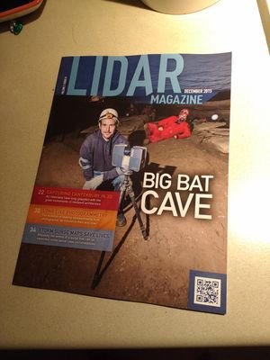
LiDARmag @lidarmag
1K Followers 30 Following Official account for LiDAR Magazine! LiDAR magazine explores all things Geotech, LiDAR, UAV, UAS and earth imaging technology including drones! Est. 2010
3Dsurvey @3DsurveyDrone
347 Followers 344 Following #Drone #mapping & #photogrammetry #software for #surveying #professionalsThe Mapping Network @MappingNetwork
700 Followers 384 Following The Mapping Network is a nationwide group of professionals providing the Hydrographic / Sediment Surveys and UAV/Drone Mapping -FAA licensed sUAS remote pilots
Wingtra @Wingtra
3K Followers 910 Following Meet WingtraOne: the professional VTOL drone for mapping & surveying
Quantum-Systems @quantumdrones
4K Followers 503 Following Transforming decision- making processes through aerial data intelligence. #eVTOL #drones for #mapping, #surveying and security applications
DroneMappingNetwork @DroneMapping
399 Followers 87 Following The Drone Mapping Network is focused specifically on mapping technology with the use of drones / UAVs.
Toledo Aerial Media @TOLAerialMedia
615 Followers 233 Following 🎞 Photo | Video | Mapping | 360 🚁 FAA Certified 107 UAS Pilots 📝 3 mil aviation | 1 mill vehicle Ins 👷🏼 Safe & Trusted Ops
HYPACK @HYPACK
1K Followers 133 Following HYPACK provides software for the hydrographic and dredging industry. We also specialize in aerial mapping and surveying, along with search and rescue software.
Nelson Aerial Pros @NelsonAerials
4K Followers 160 Following Drone Cinematography • Aerial Photography • Full Video Production • Multi Film Festival Winner • Online Print Store
Akins Aerial Imaging ... @akinsaerial
2 Followers 0 Following We capture stunning aerial photography. - FAA Licensed & Insured
The Flying Camera @TheFlyingCamSA
3K Followers 694 Following The Flying Camera is a Cape Town based aerial photography and video service. We also use our UAS system for aerial surveying , mapping. You name it , we do it
HelixNorth @Helix_North
910 Followers 894 Following Desarrollo de soluciones aéreas para la captura masiva de datos
UAVMAP Pty Ltd @uavmap
1K Followers 101 Following Unmanned Aerial Vehicle Mapping & Aerial Photography
Aerometrex @aerometrex
1K Followers 418 Following Aerometrex is a geospatial tech company with a focus on providing data-driven insights for a range of business applications globally.
Vexcel Imaging @vexcel_imaging
776 Followers 51 Following Vexcel Imaging is a global leader in aerial imaging, known for developing cutting-edge aerial cameras, mapping systems, and photogrammetric processing software.
Bluesky International... @Bluesky_int
992 Followers 449 Following Bluesky is one of the UK's leading suppliers of GIS and environment data, including aerial photo, LiDAR, thermal data, OS mapping, and tree mapping.
Applied Geographics @AppGeo
722 Followers 560 Following A full-service geospatial IT consulting firm. Creators of https://t.co/zbGgfltQRW
Scott Faculak @ScottShelby
248 Followers 1K Following That one guy that knows how to do that stuff like you see on the thing with the arpanet.
Bibop Gresta @BibopGGresta
397K Followers 8K Following I’m busy building the Hyperloop. Be energy positive!You might like